
| Memorials | : | 0 |
| Location | : | Cagle Mill, Putnam County, USA |
| Coordinate | : | 39.4853783, -86.8774567 |
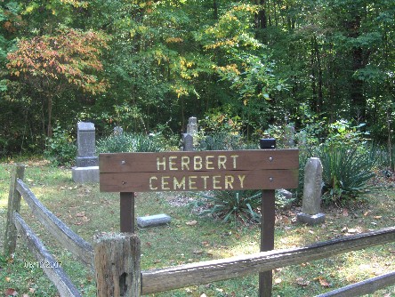
| Description | : | The cemetery is located in the Lieber State Recreational Area (SE quadrant of the NW quadrant of the NE quadrant of Section 17 Township 12N Range 4W) about 0.3 miles southwest of the entrance gate. From the Lieber State Recreational Area entrance at Indiana State Highway 243, proceed west on the road toward Hulman Beach about 0.2 miles and then south on a short loop road. Indiana Cemetery Locations, Volume 3, published by the Indiana Genealogical Society (April 2007), gives the primary cemetery name as Herbert Cemetery and lists the cemetery both in Jackson Township, Owen County, Indiana,... Read More |
frequently asked questions (FAQ):
-
Where is Herbert Cemetery?
Herbert Cemetery is located at S Lieber Road Cagle Mill, Putnam County ,Indiana , 46120USA.
-
Herbert Cemetery cemetery's updated grave count on graveviews.com?
0 memorials
-
Where are the coordinates of the Herbert Cemetery?
Latitude: 39.4853783
Longitude: -86.8774567
Nearby Cemetories:
1. Reeves Cemetery (Defunct)
Cloverdale, Putnam County, USA
Coordinate: 39.4791700, -86.8972200
2. Fertig Cemetery
Owen County, USA
Coordinate: 39.4647790, -86.9038080
3. Cunot Cemetery
Cunot, Owen County, USA
Coordinate: 39.4573097, -86.8612900
4. Salem Cemetery
Cloverdale, Putnam County, USA
Coordinate: 39.5151620, -86.8873820
5. Doe Creek Cemetery
Cloverdale, Putnam County, USA
Coordinate: 39.5005989, -86.8407974
6. T P Day Cemetery
Cunot, Owen County, USA
Coordinate: 39.4515000, -86.8376000
7. Mount Zion Cemetery
Cloverdale, Putnam County, USA
Coordinate: 39.5075010, -86.8124990
8. Asher Cemetery
Jackson Township, Owen County, USA
Coordinate: 39.4312805, -86.8614711
9. Asher Cemetery
Cunot, Owen County, USA
Coordinate: 39.4315000, -86.8586000
10. Chamberlin Cemetery
Cloverdale, Putnam County, USA
Coordinate: 39.5261345, -86.8256912
11. Grable Cemetery
Putnam County, USA
Coordinate: 39.4907990, -86.9543991
12. Harris Cemetery
Manhattan, Putnam County, USA
Coordinate: 39.5449000, -86.8930000
13. Williams-Reed Cemetery
Putnam County, USA
Coordinate: 39.5465202, -86.8692322
14. Buckskin Cemetery
Cataract, Owen County, USA
Coordinate: 39.4285920, -86.8464580
15. Friend Farm Cemetery
Putnam County, USA
Coordinate: 39.5253372, -86.9392776
16. Eltzroth Cemetery
Jordan, Owen County, USA
Coordinate: 39.4215780, -86.8653510
17. Cataract Pioneer Cemetery
Cataract, Owen County, USA
Coordinate: 39.4369220, -86.8207880
18. Mace Cemetery
Putnam County, USA
Coordinate: 39.4771996, -86.9617004
19. Matkins Cemetery
Pleasant Gardens, Putnam County, USA
Coordinate: 39.5064327, -86.9605682
20. Athey Cemetery
Washington Township, Putnam County, USA
Coordinate: 39.5029182, -86.9622116
21. Pioneer Cemetery
Cataract, Owen County, USA
Coordinate: 39.4340000, -86.8180000
22. Poland Chapel Cemetery
Poland, Clay County, USA
Coordinate: 39.4445152, -86.9535599
23. Anderson Cemetery
Poland, Clay County, USA
Coordinate: 39.4420000, -86.9534700
24. Cloverdale Cemetery
Cloverdale, Putnam County, USA
Coordinate: 39.5152016, -86.7899017