| Memorials | : | 67 |
| Location | : | Stanardsville, Greene County, USA |
| Coordinate | : | 38.3150730, -78.5402860 |
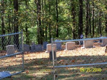
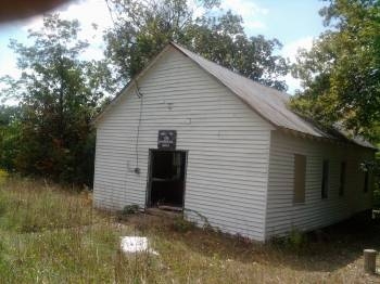
| Description | : | Once upon a time, there was a church there with the name of High Top; hence, the name given to the cemetery. Located outside of the Shenandoah National Park, the only access to the cemetery is from Dyke Road to Snow Mountian Road. Follow this road up to the end. It's also a rugged road, requiring a good ground clearing vehicle. Description provided by Ryan Funeral Home. This cemetery is 3.6 miles up the mountain from the beginning of Snow Mountain Road off Dyke Road (Rt. 810). The first half is paved but the second half is gravel with dirt/mud... Read More |
frequently asked questions (FAQ):
-
Where is High Top Cemetery?
High Top Cemetery is located at Snow Mountain Road Stanardsville, Greene County ,Virginia , 22973USA.
-
High Top Cemetery cemetery's updated grave count on graveviews.com?
67 memorials
-
Where are the coordinates of the High Top Cemetery?
Latitude: 38.3150730
Longitude: -78.5402860
Nearby Cemetories:
1. Shifflett Graveyard
Dyke, Greene County, USA
Coordinate: 38.2922750, -78.5353560
2. Blakey Family Cemetery
Dyke, Greene County, USA
Coordinate: 38.2977810, -78.5167240
3. Mount Hermon Mennonite Church Cemetery
Stanardsville, Greene County, USA
Coordinate: 38.3156920, -78.5053370
4. Nicol Family Cemetery
Geer, Greene County, USA
Coordinate: 38.2989490, -78.5062560
5. Saint James Mission Cemetery
Lydia, Greene County, USA
Coordinate: 38.3365830, -78.5101110
6. Breeden Family Cemetery
Lydia, Greene County, USA
Coordinate: 38.3366920, -78.5101050
7. Shifflett Graveyard
Dyke, Greene County, USA
Coordinate: 38.2919010, -78.5687070
8. Desmond Cemetery
Stanardsville, Greene County, USA
Coordinate: 38.2961820, -78.5063230
9. Shifflett - Slaters Graveyard
Stanardsville, Greene County, USA
Coordinate: 38.3089950, -78.4986280
10. Lydia Free Pentecostal Church Cemetery
Stanardsville, Greene County, USA
Coordinate: 38.3372930, -78.5086070
11. Runkle Family Cemetery
Geer, Greene County, USA
Coordinate: 38.2954960, -78.5041020
12. Morris Graveyard #3
Dyke, Greene County, USA
Coordinate: 38.2916390, -78.5749450
13. Bacon Hollow Cemetery
Dyke, Greene County, USA
Coordinate: 38.3067990, -78.5849380
14. Temple Hill Cemetery
Stanardsville, Greene County, USA
Coordinate: 38.3339430, -78.5005760
15. Smith - Sheler Cemetery
Lydia, Greene County, USA
Coordinate: 38.3325280, -78.4956940
16. Shifflett Graveyard #2
Dyke, Greene County, USA
Coordinate: 38.2763890, -78.5308330
17. Mount Olivet Cemetery
Dyke, Greene County, USA
Coordinate: 38.2733002, -78.5464020
18. Shiflett Family Cemetery
Dyke, Greene County, USA
Coordinate: 38.2757130, -78.5594750
19. Evergreen Cemetery
Dyke, Greene County, USA
Coordinate: 38.2716740, -78.5452480
20. Morris Graveyard #2
Dyke, Greene County, USA
Coordinate: 38.2869780, -78.5849260
21. Garth Graveyard
Stanardsville, Greene County, USA
Coordinate: 38.2930150, -78.4891220
22. Mitchell-Davis Family Cemetery
Dyke, Greene County, USA
Coordinate: 38.2716390, -78.5178330
23. B.R.I.S. Memorial Chapel Cemetery
Dyke, Greene County, USA
Coordinate: 38.2677950, -78.5522890
24. Runkle Graveyard
Stanardsville, Greene County, USA
Coordinate: 38.2934940, -78.4832590


