
| Memorials | : | 47 |
| Location | : | Edgartown, Dukes County, USA |
| Coordinate | : | 41.3862000, -70.4700800 |
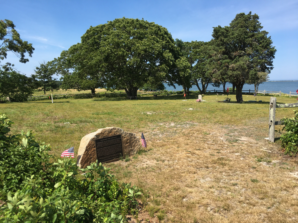
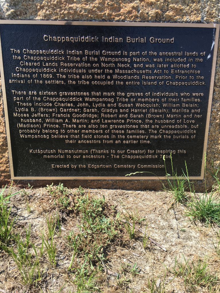
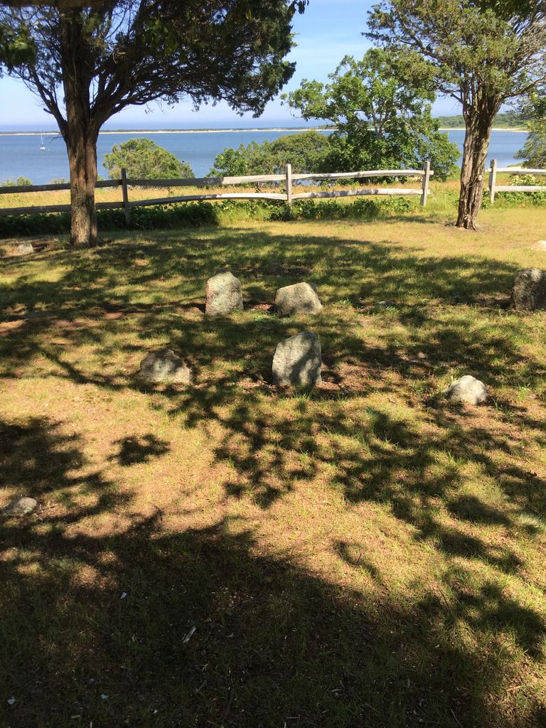
| Description | : | This cemetery is operated by the Edgartown Cemetery Commission. The Edgartown Assessor identifies this cemetery on Map 31 Lot 16.2 as "Old Indian Burial Ground". The predominantly unmarked graves of the Chappaquiddick Wampanoag tribe occupy the center of the cemetery. The Massachusetts Historical Commission does not refer to this cemetery in MACRIS. This burial place is referenced to in the book "Vital Records of Edgartown, Massachusetts to 1850", Published by the New England Historic Genealogical Society, as G.R.4. |
frequently asked questions (FAQ):
-
Where is Hilltop Cemetery?
Hilltop Cemetery is located at 32 Jeffers Lane Edgartown, Dukes County ,Massachusetts ,USA.
-
Hilltop Cemetery cemetery's updated grave count on graveviews.com?
47 memorials
-
Where are the coordinates of the Hilltop Cemetery?
Latitude: 41.3862000
Longitude: -70.4700800
Nearby Cemetories:
1. Toms Neck Farm Cemetery
Edgartown, Dukes County, USA
Coordinate: 41.3780900, -70.4600200
2. Tower Hill Cemetery
Edgartown, Dukes County, USA
Coordinate: 41.3809600, -70.5112400
3. Federated Church Memorial Garden
Edgartown, Dukes County, USA
Coordinate: 41.3884800, -70.5149500
4. Old Westside Cemetery
Edgartown, Dukes County, USA
Coordinate: 41.3892200, -70.5182400
5. New Westside Cemetery
Edgartown, Dukes County, USA
Coordinate: 41.3887600, -70.5208200
6. Farm Neck Cemetery
Oak Bluffs, Dukes County, USA
Coordinate: 41.4278800, -70.5709300
7. Sarah Wilbur Gravesite
Oak Bluffs, Dukes County, USA
Coordinate: 41.4156700, -70.5819800
8. Oak Grove Cemetery
Oak Bluffs, Dukes County, USA
Coordinate: 41.4555600, -70.5680200
9. Sacred Heart Cemetery
Oak Bluffs, Dukes County, USA
Coordinate: 41.4533800, -70.5714100
10. Smith Family Cemetery
Oak Bluffs, Dukes County, USA
Coordinate: 41.4243020, -70.6005530
11. Eastville Cemetery
Oak Bluffs, Dukes County, USA
Coordinate: 41.4575400, -70.5803200
12. Graves near Old House Pond
West Tisbury, Dukes County, USA
Coordinate: 41.4192700, -70.6130400
13. South End Cemetery
Tisbury, Dukes County, USA
Coordinate: 41.4513100, -70.6045900
14. Sailors Burying Ground
Tisbury, Dukes County, USA
Coordinate: 41.4402600, -70.6146000
15. Tisbury Village Cemetery
Tisbury, Dukes County, USA
Coordinate: 41.4545600, -70.6053300
16. Grace Episcopal Churchyard
Vineyard Haven, Dukes County, USA
Coordinate: 41.4581253, -70.6048724
17. Oak Grove Cemetery
Tisbury, Dukes County, USA
Coordinate: 41.4514008, -70.6138992
18. Marthas Vineyard Hebrew Cemetery
Tisbury, Dukes County, USA
Coordinate: 41.4515900, -70.6144520
19. West Chop Cemetery
Tisbury, Dukes County, USA
Coordinate: 41.4679400, -70.5998400
20. Daggett Burial Ground
Tisbury, Dukes County, USA
Coordinate: 41.4461200, -70.6201800
21. West Tisbury Village Cemetery
West Tisbury, Dukes County, USA
Coordinate: 41.3875600, -70.6739800
22. Lambert's Cove Cemetery
West Tisbury, Dukes County, USA
Coordinate: 41.4451500, -70.6626000
23. North Tisbury Burial Ground
West Tisbury, Dukes County, USA
Coordinate: 41.4067800, -70.6771800
24. Christiantown Memorial Cemetery
West Tisbury, Dukes County, USA
Coordinate: 41.4235000, -70.6749200