
| Memorials | : | 32 |
| Location | : | Grand Rapids, Kent County, USA |
| Phone | : | 616-453-1636 |
| Website | : | grcathcem.org |
| Coordinate | : | 42.9953003, -85.7153015 |
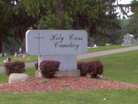
| Description | : | The cemetery is located on the northeast corner of the intersection of Walker Avenue NW and Richmond Street NW. The U.S. Geological Survey (USGS) Geographic Names Information System (GNIS) feature ID for the cemetery is 628469 (Holy Cross Cemetery / Polish Catholic Cemetery). |
frequently asked questions (FAQ):
-
Where is Holy Cross Cemetery?
Holy Cross Cemetery is located at 2000 Walker NW Grand Rapids, Kent County ,Michigan , 49504USA.
-
Holy Cross Cemetery cemetery's updated grave count on graveviews.com?
31 memorials
-
Where are the coordinates of the Holy Cross Cemetery?
Latitude: 42.9953003
Longitude: -85.7153015
Nearby Cemetories:
1. Greenwood Cemetery
Grand Rapids, Kent County, USA
Coordinate: 42.9892006, -85.7055969
2. Washington Park Memorial Gardens
Grand Rapids, Kent County, USA
Coordinate: 42.9944000, -85.7007980
3. Saints Peter and Paul Cemetery
Grand Rapids, Kent County, USA
Coordinate: 42.9963890, -85.6997220
4. Achim Cemetery
Grand Rapids, Kent County, USA
Coordinate: 42.9961014, -85.6994019
5. Lithuanian Freedom Cemetery
Grand Rapids, Kent County, USA
Coordinate: 42.9956430, -85.6991170
6. Mount Calvary Cemetery
Grand Rapids, Kent County, USA
Coordinate: 42.9846992, -85.7043991
7. Saint Pauls Anglican Church Columbarium
Grand Rapids, Kent County, USA
Coordinate: 42.9711200, -85.7321700
8. Brooklawn Cemetery
Walker, Kent County, USA
Coordinate: 43.0280991, -85.7300034
9. Gerald R Ford Museum
Grand Rapids, Kent County, USA
Coordinate: 42.9668140, -85.6771000
10. Second Congregational UCC Memorial Garden
Grand Rapids, Kent County, USA
Coordinate: 43.0032900, -85.6549900
11. Mill Creek Cemetery
Walker, Kent County, USA
Coordinate: 43.0288890, -85.6705560
12. Grand Rapids Veterans Home Cemetery
Grand Rapids, Kent County, USA
Coordinate: 43.0182915, -85.6588898
13. First United Methodist Church Columbarium
Grand Rapids, Kent County, USA
Coordinate: 42.9634200, -85.6633300
14. Westminster Presbyterian Church Columbarium
Grand Rapids, Kent County, USA
Coordinate: 42.9619070, -85.6646760
15. United Church of Christ Cemetery
Comstock Park, Kent County, USA
Coordinate: 43.0359210, -85.6684260
16. Central Reformed Church Crypt
Grand Rapids, Kent County, USA
Coordinate: 42.9634410, -85.6563430
17. Fairplains Cemetery
Grand Rapids, Kent County, USA
Coordinate: 43.0005989, -85.6421967
18. Saint Andrews Episcopal Gardens
Grand Rapids, Kent County, USA
Coordinate: 43.0142030, -85.6430840
19. Holy Trinity Cemetery
Alpine Township, Kent County, USA
Coordinate: 43.0511017, -85.6992035
20. Rosedale Memorial Park
Tallmadge Township, Ottawa County, USA
Coordinate: 42.9721160, -85.7876870
21. Fulton Street Cemetery
Grand Rapids, Kent County, USA
Coordinate: 42.9639200, -85.6486400
22. Saint Andrews Catholic Cemetery
Grand Rapids, Kent County, USA
Coordinate: 42.9463997, -85.6567001
23. Oakhill Cemetery
Grand Rapids, Kent County, USA
Coordinate: 42.9411011, -85.6517029
24. River Bend Cemetery
Walker, Kent County, USA
Coordinate: 42.9352989, -85.7750015