| Memorials | : | 4 |
| Location | : | Coal Valley, Rock Island County, USA |
| Coordinate | : | 41.3987846, -90.4469910 |
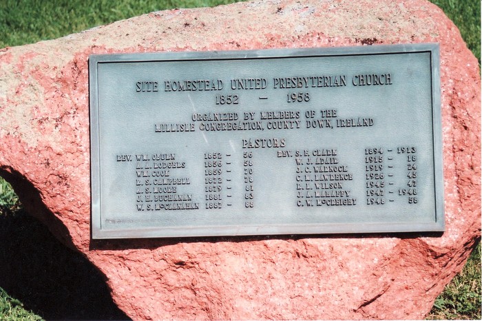
| Description | : | *As of 12.01.2012, this cemetery is complete with names and photos of each tombstone. There are only a couple of tombstones that are unreadable. - Coker The Homestead Cemetery is located on the site of the Homestead United Presbyterian Church, 1852-1958, just southeast of Coal Valley, Rock Island County, Illinois. Directions: In Coal Valley, from U.S. Route 150, turn south on West 3rd Street. This road turns into 104th Street. At the "Arrowhead Ranch" sign, turn left (east), which is 120th Avenue. Go 1 mile. The cemetery is on the right, past a ranch style house.... Read More |
frequently asked questions (FAQ):
-
Where is Homestead Cemetery?
Homestead Cemetery is located at Coal Valley, Rock Island County ,Illinois ,USA.
-
Homestead Cemetery cemetery's updated grave count on graveviews.com?
4 memorials
-
Where are the coordinates of the Homestead Cemetery?
Latitude: 41.3987846
Longitude: -90.4469910
Nearby Cemetories:
1. Oakleaf Memorial Park
Coal Valley, Rock Island County, USA
Coordinate: 41.4002876, -90.4760295
2. Rock Island County Cemetery
Coal Valley, Rock Island County, USA
Coordinate: 41.4047220, -90.4752450
3. Beulah Rural Township Cemetery
Coal Valley, Rock Island County, USA
Coordinate: 41.3695800, -90.4698100
4. Coal Valley Cemetery
Coal Valley, Rock Island County, USA
Coordinate: 41.4385986, -90.4649963
5. Niabi Zoo
Coal Valley, Rock Island County, USA
Coordinate: 41.4439163, -90.4342957
6. Western Township Cemetery
Orion, Henry County, USA
Coordinate: 41.3713989, -90.3968964
7. Glennwood Cemetery
Colona Township, Henry County, USA
Coordinate: 41.4530983, -90.4039001
8. Orion Lutheran Cemetery
Orion, Henry County, USA
Coordinate: 41.3572006, -90.3668976
9. Rose Lawn Memorial Estate
Moline, Rock Island County, USA
Coordinate: 41.4742012, -90.4550018
10. Greenbush Cemetery
Mercer County, USA
Coordinate: 41.3189011, -90.4499969
11. Bowlesburg Cemetery
Silvis, Rock Island County, USA
Coordinate: 41.4749985, -90.4135971
12. Moline Memorial Park
Moline, Rock Island County, USA
Coordinate: 41.4807300, -90.4683400
13. South Moline Township Cemetery
Moline, Rock Island County, USA
Coordinate: 41.4770737, -90.4966125
14. Greenview Memorial Gardens
East Moline, Rock Island County, USA
Coordinate: 41.4841000, -90.4091440
15. Sherrard Cemetery
Sherrard, Mercer County, USA
Coordinate: 41.3194008, -90.5128021
16. William Carr Cemetery
Rock Island, Rock Island County, USA
Coordinate: 41.4691010, -90.5426025
17. Friends Cemetery
Sherrard, Mercer County, USA
Coordinate: 41.3175011, -90.5263977
18. Schoening Cemetery
Rock Island County, USA
Coordinate: 41.3297005, -90.5492020
19. Carbon Cliff Cemetery
Rock Island County, USA
Coordinate: 41.4963500, -90.3926500
20. Rock Island Memorial Park Cemetery
Rock Island, Rock Island County, USA
Coordinate: 41.4685900, -90.5553700
21. Woods Cemetery
Milan, Rock Island County, USA
Coordinate: 41.3414001, -90.5686035
22. Saint Mary's Cemetery
East Moline, Rock Island County, USA
Coordinate: 41.5093994, -90.4569016
23. Morristown Cemetery
Morristown, Henry County, USA
Coordinate: 41.3960991, -90.2960968
24. Riverside Cemetery
Moline, Rock Island County, USA
Coordinate: 41.5078011, -90.4918976


