
| Memorials | : | 0 |
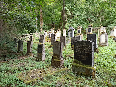
| Location | : | Sennfeld, Neckar-Odenwald-Kreis, Germany |
| Coordinate | : | 49.3835200, 9.3930700 |
frequently asked questions (FAQ):
-
Where is Jüdischer Friedhof Sennfeld?
Jüdischer Friedhof Sennfeld is located at Sennfeld, Neckar-Odenwald-Kreis ,Baden-Württemberg , 74740Germany.
-
Jüdischer Friedhof Sennfeld cemetery's updated grave count on graveviews.com?
0 memorials
-
Where are the coordinates of the Jüdischer Friedhof Sennfeld?
Latitude: 49.3835200
Longitude: 9.3930700
Nearby Cemetories:
1. Friedhof Sennfeld
Sennfeld, Neckar-Odenwald-Kreis, Germany
Coordinate: 49.3789680, 9.3863162
2. Friedhof Adelsheim
Adelsheim, Neckar-Odenwald-Kreis, Germany
Coordinate: 49.4047430, 9.3864750
3. Friedhof Möckmühl
Möckmühl, Landkreis Heilbronn, Germany
Coordinate: 49.3282500, 9.3544400
4. Jüdischer Friedhof Merchingen
Merchingen, Neckar-Odenwald-Kreis, Germany
Coordinate: 49.4010700, 9.5150500
5. Friedhof Schefflenz
Mittelschefflenz, Neckar-Odenwald-Kreis, Germany
Coordinate: 49.4064066, 9.2726007
6. Waldfriedhof Schöntal
Schöntal, Hohenlohekreis, Germany
Coordinate: 49.3733000, 9.5271500
7. Friedhof Jagsthausen
Jagsthausen, Landkreis Heilbronn, Germany
Coordinate: 49.3116250, 9.4726030
8. Kloster Schöntal
Schöntal, Hohenlohekreis, Germany
Coordinate: 49.3281000, 9.5047000
9. Jüdischer Friedhof Berlichingen
Berlichingen, Hohenlohekreis, Germany
Coordinate: 49.3152500, 9.4951100
10. Friedhof Züttlingen
Züttlingen, Landkreis Heilbronn, Germany
Coordinate: 49.2974800, 9.3301700
11. Kath. Pfarrkirche St. Georg
Aschhausen, Hohenlohekreis, Germany
Coordinate: 49.3709720, 9.5415140
12. Friedhof Aschhausen
Schöntal, Hohenlohekreis, Germany
Coordinate: 49.3713401, 9.5420303
13. Friedhof Bödigheim
Bödigheim, Neckar-Odenwald-Kreis, Germany
Coordinate: 49.4791100, 9.3137500
14. Jüdischer Friedhof Bödigheim
Bödigheim, Neckar-Odenwald-Kreis, Germany
Coordinate: 49.4802310, 9.3098440
15. Friedhof Westernhausen
Westernhausen, Hohenlohekreis, Germany
Coordinate: 49.3390615, 9.5602575
16. Jüdischer Friedhof Stein am Kocher
Stein am Kocher, Landkreis Heilbronn, Germany
Coordinate: 49.2730800, 9.3065400
17. Friedhof Muckental
Muckental, Neckar-Odenwald-Kreis, Germany
Coordinate: 49.4265800, 9.2086000
18. Friedhof Hettingen
Neckarzimmern, Neckar-Odenwald-Kreis, Germany
Coordinate: 49.5194500, 9.3687600
19. Friedhof Bürg
Neuenstadt am Kocher, Landkreis Heilbronn, Germany
Coordinate: 49.2448400, 9.3355900
20. Friedhof Laudenberg
Laudenberg, Neckar-Odenwald-Kreis, Germany
Coordinate: 49.4789099, 9.2181442
21. Friedhof Buchen
Buchen, Neckar-Odenwald-Kreis, Germany
Coordinate: 49.5256080, 9.3214510
22. Jüdischer Friedhof Eubigheim
Eubigheim, Main-Tauber-Kreis, Germany
Coordinate: 49.4984600, 9.5460300
23. Nikolauskirche
Neuenstadt am Kocher, Landkreis Heilbronn, Germany
Coordinate: 49.2371300, 9.3301400
24. Friedhof Tiefenbach
Tiefenbach, Landkreis Heilbronn, Germany
Coordinate: 49.2965600, 9.2006300