
| Memorials | : | 0 |
| Location | : | Mankato, Jewell County, USA |
| Coordinate | : | 39.7646294, -98.1841812 |
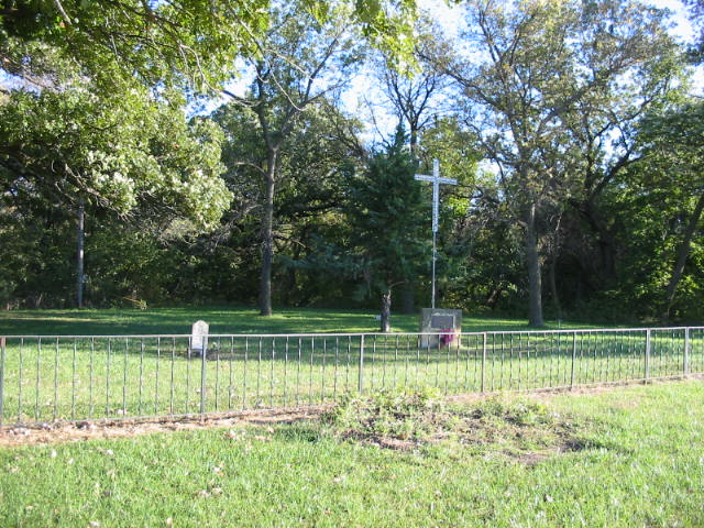
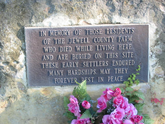
| Description | : | This cemetery is on private property. It has a narrow trail to drive on or is with in walking distance from the main road.The driveway is on the East side of the property. There are only two stones visible. It is unknown how many are buried here. I was told today (09/18/09)that as many as 50 graves have been located by a local person with dowsing rods. She thinks there may be more in the farm field near by. |
frequently asked questions (FAQ):
-
Where is Jewell County Farm Cemetery?
Jewell County Farm Cemetery is located at Mankato, Jewell County ,Kansas , 66956USA.
-
Jewell County Farm Cemetery cemetery's updated grave count on graveviews.com?
0 memorials
-
Where are the coordinates of the Jewell County Farm Cemetery?
Latitude: 39.7646294
Longitude: -98.1841812
Nearby Cemetories:
1. East Lutheran Cemetery
Mankato, Jewell County, USA
Coordinate: 39.7805700, -98.1940500
2. Saint Theresa Catholic Cemetery
Mankato, Jewell County, USA
Coordinate: 39.7886009, -98.2238998
3. Mount Hope Cemetery
Mankato, Jewell County, USA
Coordinate: 39.7825012, -98.2300034
4. East Buffalo Cemetery
Jewell, Jewell County, USA
Coordinate: 39.7411800, -98.1344400
5. West Lutheran Cemetery
Mankato, Jewell County, USA
Coordinate: 39.7852150, -98.2694250
6. McGehee Cemetery
Jewell, Jewell County, USA
Coordinate: 39.7052994, -98.2502975
7. Jewell City Cemetery
Jewell, Jewell County, USA
Coordinate: 39.6693993, -98.1671982
8. Pleasant View Cemetery
Montrose, Jewell County, USA
Coordinate: 39.7556000, -98.0539017
9. Delta Cemetery
Jewell County, USA
Coordinate: 39.7961006, -98.0556030
10. Wallace Cemetery
Jewell, Jewell County, USA
Coordinate: 39.6680984, -98.1046982
11. Steuben Cemetery
Webber, Jewell County, USA
Coordinate: 39.8717330, -98.1301370
12. Union Cemetery
Burr Oak, Jewell County, USA
Coordinate: 39.6408005, -98.2127991
13. Couch Cemetery
Jewell, Jewell County, USA
Coordinate: 39.6401100, -98.2134094
14. Burr Oak Cemetery
Burr Oak, Jewell County, USA
Coordinate: 39.8652992, -98.2846985
15. German Baptist Brethren Cemetery II
Burr Oak, Jewell County, USA
Coordinate: 39.8720860, -98.2786470
16. Pleasant View Cemetery
Jewell County, USA
Coordinate: 39.7666900, -98.3668040
17. German Baptist Brethren Cemetery I
Burr Oak, Jewell County, USA
Coordinate: 39.8787900, -98.2955400
18. Switzers Gap Cemetery
Jewell County, USA
Coordinate: 39.8422012, -98.0255966
19. Randall Cemetery
Randall, Jewell County, USA
Coordinate: 39.6465988, -98.0475006
20. Zion Cemetery
Jewell County, USA
Coordinate: 39.7672005, -98.3914032
21. Ionia Cemetery
Ionia, Jewell County, USA
Coordinate: 39.6772003, -98.3574982
22. Balch Cemetery
Formoso, Jewell County, USA
Coordinate: 39.7983017, -97.9807968
23. Montana Cemetery
Jewell County, USA
Coordinate: 39.9152985, -98.1082993
24. Baker Cemetery
Jewell County, USA
Coordinate: 39.8581009, -98.3617020