
| Memorials | : | 0 |
| Location | : | Woerden Municipality, Netherlands |
| Coordinate | : | 52.0885800, 4.8813300 |
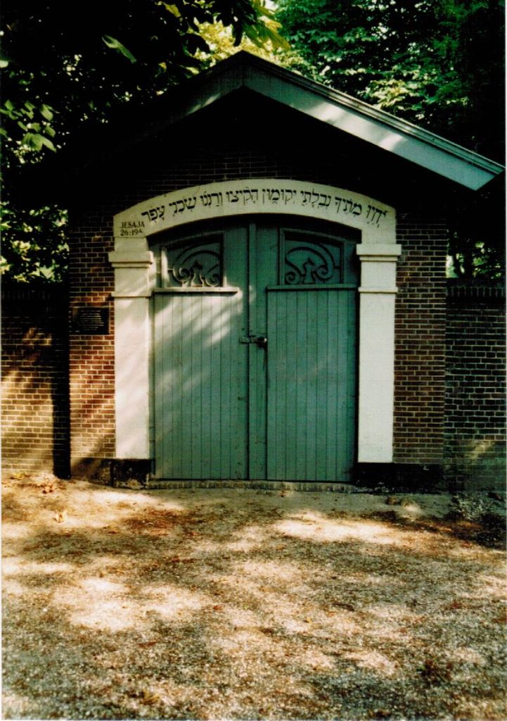
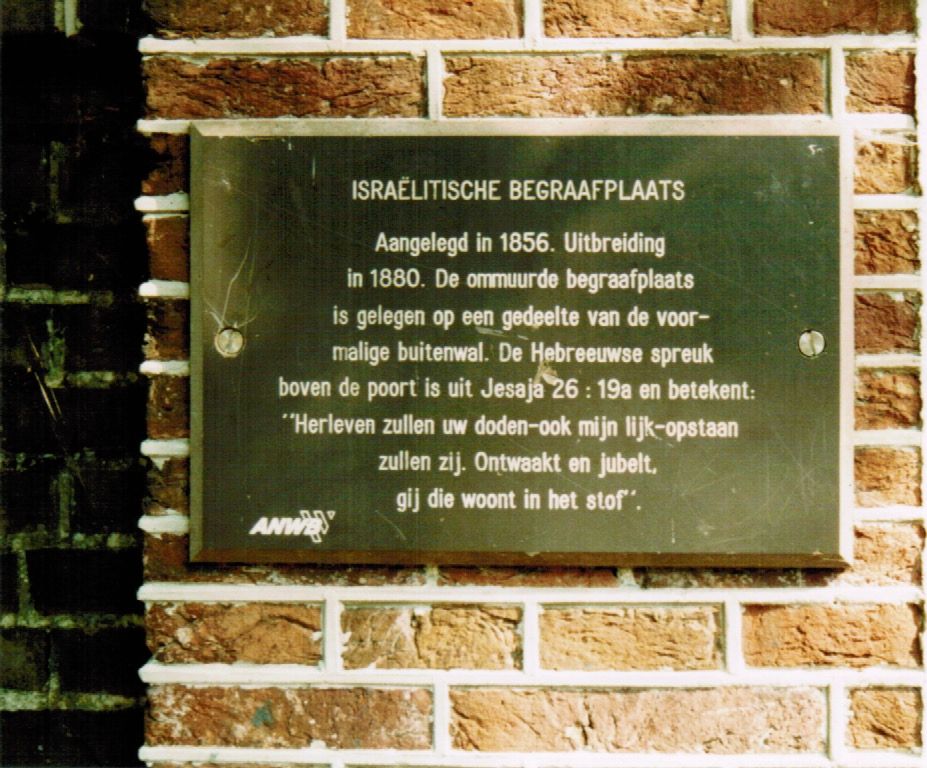
| Description | : | In use from 1856-1927. The cemetery was expanded in 1880. Until 1925 there was a border with trees and bushes. That year, a wall with a gatehouse was constructed. It was renovated during 2011-2013. |
frequently asked questions (FAQ):
-
Where is Joodse Begraafsplaats?
Joodse Begraafsplaats is located at Westdam Woerden Municipality ,Utrecht , 3441 GANetherlands.
-
Joodse Begraafsplaats cemetery's updated grave count on graveviews.com?
0 memorials
-
Where are the coordinates of the Joodse Begraafsplaats?
Latitude: 52.0885800
Longitude: 4.8813300
Nearby Cemetories:
1. Algemene Begraafplaats Rijnhof
Woerden, Woerden Municipality, Netherlands
Coordinate: 52.0970000, 4.9024700
2. Algemene Begraafplaats Waarder
Waarder, Bodegraven-Reeuwijk Municipality, Netherlands
Coordinate: 52.0645703, 4.8223924
3. Begraafplaats ‘t Spijck
Harmelen, Woerden Municipality, Netherlands
Coordinate: 52.1004944, 4.9735318
4. Montfoort General Cemetery
Montfoort, Montfoort Municipality, Netherlands
Coordinate: 52.0434800, 4.9451700
5. Oudewater Protestant Cemetery
Oudewater, Oudewater Municipality, Netherlands
Coordinate: 52.0207700, 4.8762500
6. Algemene Begraafplaats Vredehof
Bodegraven, Bodegraven-Reeuwijk Municipality, Netherlands
Coordinate: 52.0833000, 4.7602700
7. Parochiekerk van Sint-Maarten Begraafplaats
Noorden, Nieuwkoop Municipality, Netherlands
Coordinate: 52.1634800, 4.8257500
8. Oud Protestant begraafplaats
Vleuten, Utrecht Municipality, Netherlands
Coordinate: 52.1065676, 5.0124286
9. Katholieke begraafplaats
Vleuten, Utrecht Municipality, Netherlands
Coordinate: 52.1007835, 5.0162086
10. Rooms-Katholiek Kerkhof Sint-Willibrorduskerk
Bodegraven, Bodegraven-Reeuwijk Municipality, Netherlands
Coordinate: 52.0842000, 4.7441500
11. Algemene Begraafplaats
Nieuwkoop, Nieuwkoop Municipality, Netherlands
Coordinate: 52.1497407, 4.7801137
12. RK Kerkhof Onze Lieve Vrouwe Hemelvaartkerk
Nieuwkoop, Nieuwkoop Municipality, Netherlands
Coordinate: 52.1489920, 4.7773200
13. Benschop General Cemetery
Benschop, Lopik Municipality, Netherlands
Coordinate: 52.0097300, 4.9784100
14. Begraafplaats Buitendorp
Zwammerdam, Alphen aan den Rijn Municipality, Netherlands
Coordinate: 52.1039000, 4.7203000
15. Aarlanderveen Begraafplaats
Aarlanderveen, Alphen aan den Rijn Municipality, Netherlands
Coordinate: 52.1348800, 4.7366500
16. Voormalig Kerkhof Nederlands-Hervormde Kerk
Aarlanderveen, Alphen aan den Rijn Municipality, Netherlands
Coordinate: 52.1405690, 4.7288903
17. Maarssen General Cemetery
Maarssen, Stichtse Vecht Municipality, Netherlands
Coordinate: 52.1451469, 5.0306710
18. Wilnis Dutch Reformed Cemetery
Wilnis, De Ronde Venen Municipality, Netherlands
Coordinate: 52.1965600, 4.9049700
19. Hoge Akker Begraafplaats
IJsselstein, IJsselstein Municipality, Netherlands
Coordinate: 52.0357500, 5.0380900
20. Algemene Begraafplaats Zevenhoven
Zevenhoven, Nieuwkoop Municipality, Netherlands
Coordinate: 52.1808458, 4.7834473
21. Oude Algemene Begraafplaats
Breukelen, Stichtse Vecht Municipality, Netherlands
Coordinate: 52.1720700, 4.9986100
22. Wilnis Katholieke Begraafplaats
Wilnis, De Ronde Venen Municipality, Netherlands
Coordinate: 52.1999700, 4.8737100
23. De Ronde Venen General Cemetery
Wilnis, De Ronde Venen Municipality, Netherlands
Coordinate: 52.2010700, 4.9060900
24. Kerkhof HH. Petrus en Pauluskerk
Aarlanderveen, Alphen aan den Rijn Municipality, Netherlands
Coordinate: 52.1482300, 4.7221960