
| Memorials | : | 2 |
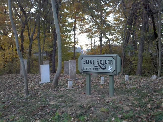
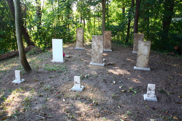
| Location | : | Boaz, Wood County, USA |
| Coordinate | : | 39.3617930, -81.4966460 |
| Description | : | The Elias Keller Family Cemetery was restored the summer of 2010. Assisted by Joe Fetty of Vienna, WV. This cemetery was badly overgrown and littered with trash. After removing brush and trimming trees, I cleaned several headstones. All grave markers had been knocked over and the base was nothing but cement poured around the base of each headstone. I constructed a form and produced all new base stones to hold each headstone and footstone upright. After completion of repairs and construction, I place silk flowers on each grave. Two local little girls also placed small field flowers on the markers. To... Read More |
frequently asked questions (FAQ):
-
Where is Keller Cemetery?
Keller Cemetery is located at Boaz, Wood County ,West Virginia ,USA.
-
Keller Cemetery cemetery's updated grave count on graveviews.com?
1 memorials
-
Where are the coordinates of the Keller Cemetery?
Latitude: 39.3617930
Longitude: -81.4966460

Nearby Cemetories:
1. Johnson Cemetery
Wood County, USA
Coordinate: 39.3656006, -81.4966965
2. Uhl Cemetery
Wood County, USA
Coordinate: 39.3694000, -81.4922028
3. Pugh Cemetery
Wood County, USA
Coordinate: 39.3711014, -81.4841995
4. Varner Cemetery
Parkersburg, Wood County, USA
Coordinate: 39.3470430, -81.5004800
5. Mayo Cemetery
Wood County, USA
Coordinate: 39.3488998, -81.4847031
6. Henderson Cemetery
Boaz, Wood County, USA
Coordinate: 39.3744011, -81.4792023
7. Jacob White Gravesite
Summit, Wood County, USA
Coordinate: 39.3394330, -81.5001000
8. Wiggins Cemetery
Parkersburg, Wood County, USA
Coordinate: 39.3367250, -81.4888610
9. Owens Cemetery
Parkersburg, Wood County, USA
Coordinate: 39.3369100, -81.4632660
10. Tunnel Cemetery
Fleming, Washington County, USA
Coordinate: 39.3959999, -81.5439987
11. Jesterville Cemetery
Parkersburg, Wood County, USA
Coordinate: 39.3145340, -81.4704210
12. Harris Family Cemetery
Washington County, USA
Coordinate: 39.3606650, -81.5725640
13. Harmar Cemetery
Marietta, Washington County, USA
Coordinate: 39.4166985, -81.4638977
14. Rosemar Methodist Cemetery
Wood County, USA
Coordinate: 39.3050730, -81.5259200
15. Christopher Cemetery
McAvan, Washington County, USA
Coordinate: 39.3830000, -81.5710000
16. Saint Lukes Episcopal Church Memorial Garden
Marietta, Washington County, USA
Coordinate: 39.4172964, -81.4556770
17. Kinnaird Cemetery
Wood County, USA
Coordinate: 39.3976430, -81.4280890
18. Ogden Cemetery
Parkersburg, Wood County, USA
Coordinate: 39.3006000, -81.5252550
19. Mound Cemetery
Marietta, Washington County, USA
Coordinate: 39.4199829, -81.4518661
20. Evergreen Cemetery North
Parkersburg, Wood County, USA
Coordinate: 39.2949982, -81.5156021
21. Spring Grove Cemetery
Parkersburg, Wood County, USA
Coordinate: 39.2975006, -81.5325012
22. Saint Marys Old Cemetery
Marietta, Washington County, USA
Coordinate: 39.4282112, -81.4629593
23. Hopkins Cemetery
Washington County, USA
Coordinate: 39.3484080, -81.5876260
24. Wenmoth Cemetery
Parkersburg, Wood County, USA
Coordinate: 39.2943330, -81.4624530