
| Memorials | : | 0 |
| Location | : | Landkreis Gotha, Germany |
| Coordinate | : | 50.8699730, 10.5578180 |
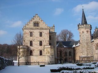
| Description | : | Benedictine abbey founded by the Thuringian Landgrave, Louis the Springer, in 1085. It was the proprietary monastery and burial ground of the Ludovingian landgraves like Hermann I who was entombed here in 1217. The monastery became less important after the extinction of the Ludovingians in 1247. Nevertheless, their Wettin successors still used it as a dynastic burial site and an important chronicle was commissioned around 1340, reflecting the history of Thuringia and Germany back to the 6th century. The monastery was looted and sacked during the German Peasants' War in 1525. The monks took refuge within the walls of Gotha,... Read More |
frequently asked questions (FAQ):
-
Where is Kloster Reinhardsbrunn?
Kloster Reinhardsbrunn is located at Landkreis Gotha ,Thüringen ,Germany.
-
Kloster Reinhardsbrunn cemetery's updated grave count on graveviews.com?
0 memorials
-
Where are the coordinates of the Kloster Reinhardsbrunn?
Latitude: 50.8699730
Longitude: 10.5578180
Nearby Cemetories:
1. Friedhof Friedrichroda
Friedrichroda, Landkreis Gotha, Germany
Coordinate: 50.8646060, 10.5738410
2. Friedhof Finsterbergen
Finsterbergen, Landkreis Gotha, Germany
Coordinate: 50.8366529, 10.5914414
3. Friedhof Hörselgau
Horselgau, Landkreis Gotha, Germany
Coordinate: 50.9220793, 10.5794644
4. Mechterstädt Cemetery
Mechterstadt, Landkreis Gotha, Germany
Coordinate: 50.9500000, 10.5333300
5. Ohrdruf Concentration Camp
Gotha, Landkreis Gotha, Germany
Coordinate: 50.8333000, 10.7333000
6. Friedhof Ohrdruf
Ohrdruf, Landkreis Gotha, Germany
Coordinate: 50.8318288, 10.7325307
7. Schlosskirche Friedenstein
Gotha, Landkreis Gotha, Germany
Coordinate: 50.9462680, 10.7045350
8. Margarethenkirche
Gotha, Landkreis Gotha, Germany
Coordinate: 50.9502500, 10.7050000
9. Friedhof Melborn
Melborn, Wartburgkreis, Germany
Coordinate: 50.9748713, 10.4470766
10. Hauptfriedhof
Gotha, Landkreis Gotha, Germany
Coordinate: 50.9643730, 10.7093100
11. Siebleben Friedhof
Siebleben, Landkreis Gotha, Germany
Coordinate: 50.9431230, 10.7434460
12. Friedhof Schweina
Schweina, Wartburgkreis, Germany
Coordinate: 50.8262100, 10.3341480
13. Friedhof Herrenbreitungen
Benshausen, Landkreis Schmalkalden-Meiningen, Germany
Coordinate: 50.7569660, 10.3438060
14. Georgenkirche
Eisenach, Stadtkreis Eisenach, Germany
Coordinate: 50.9743460, 10.3194990
15. Alter Friedhof
Eisenach, Stadtkreis Eisenach, Germany
Coordinate: 50.9747100, 10.3154030
16. Friedhof Hötzelroda
Eisenach, Stadtkreis Eisenach, Germany
Coordinate: 51.0128570, 10.3702500
17. Friedhof Eckardtshausen
Marksuhl, Wartburgkreis, Germany
Coordinate: 50.9147550, 10.2673860
18. Hauptfriedhof
Eisenach, Stadtkreis Eisenach, Germany
Coordinate: 50.9856170, 10.3172630
19. Viernau Friedhof
Viernau, Landkreis Schmalkalden-Meiningen, Germany
Coordinate: 50.6628700, 10.5601710
20. Husenfriedhof
Bad Salzungen, Wartburgkreis, Germany
Coordinate: 50.8126213, 10.2198917
21. Evangelelischer friedof kornhochheim
Neudietendorf, Landkreis Gotha, Germany
Coordinate: 50.9085125, 10.9096778
22. Evangelischer Friedhof Kornhochheim
Kornhochheim, Landkreis Gotha, Germany
Coordinate: 50.9010121, 10.9158001
23. Saint Bonifatius Church Cemetery
Gierstädt, Landkreis Gotha, Germany
Coordinate: 51.0408740, 10.8230250
24. Friedhof Gierstaedt
Gierstädt, Landkreis Gotha, Germany
Coordinate: 51.0405100, 10.8245910