
| Memorials | : | 0 |
| Location | : | Imst, Imst Bezirk, Austria |
| Coordinate | : | 47.2206390, 10.7573330 |
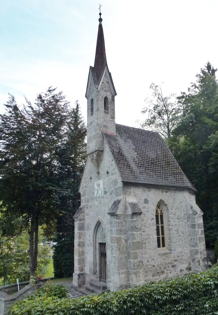
| Description | : | Queen Marie von Sachsen had this royal chapel (German: Königskapelle) built in honor of her late husband King Friedrich August II von Sachsen, who had died in 1854 of injuries suffered during an accident while traveling in nearby Imst. Though he was not buried here, his son Friedrich Christian von Sachsen dictated that the chapel shall be used as future burial spot for members of the Royal House of Wettin (a millennial old dynasty that had ruled Saxony for centuries). |
frequently asked questions (FAQ):
-
Where is Königskapelle Brennbichl?
Königskapelle Brennbichl is located at Imst, Imst Bezirk ,Tyrol (Tirol) ,Austria.
-
Königskapelle Brennbichl cemetery's updated grave count on graveviews.com?
0 memorials
-
Where are the coordinates of the Königskapelle Brennbichl?
Latitude: 47.2206390
Longitude: 10.7573330
Nearby Cemetories:
1. Stift Stams
Stams, Imst Bezirk, Austria
Coordinate: 47.2778400, 10.9844100
2. Katharina Parrish Catholic Cemetery
Langenfeld, Imst Bezirk, Austria
Coordinate: 47.0719701, 10.9714527
3. Kirchhof Ehrwald
Ehrwald, Reutte Bezirk, Austria
Coordinate: 47.3987500, 10.9203000
4. Friedhof Nauders Cemetery
Nauders, Landeck Bezirk, Austria
Coordinate: 46.9686172, 10.8290999
5. Pfunds War Memorial
Pfunds, Landeck Bezirk, Austria
Coordinate: 46.9679800, 10.5409800
6. Friedhof Grainau
Grainau, Landkreis Garmisch-Partenkirchen, Germany
Coordinate: 47.4709980, 11.0253050
7. Alter Friedhof St. Sebastian in Füssen
Fussen, Landkreis Ostallgäu, Germany
Coordinate: 47.5680860, 10.7030540
8. Stadtfriedhof Partenkirchen
Garmisch-Partenkirchen, Landkreis Garmisch-Partenkirchen, Germany
Coordinate: 47.5018700, 11.0836100
9. Friedhof Garmisch
Garmisch-Partenkirchen, Landkreis Garmisch-Partenkirchen, Germany
Coordinate: 47.5018450, 11.0836960
10. Waldfriedhof Füssen
Fussen, Landkreis Ostallgäu, Germany
Coordinate: 47.5795220, 10.7073350
11. Katholischer Friedhof Weissensee bei Füssen
Fussen, Landkreis Ostallgäu, Germany
Coordinate: 47.5735040, 10.6389450
12. Friedhof Waltenhofen
Waltenhofen, Landkreis Oberallgäu, Germany
Coordinate: 47.5863890, 10.7291110
13. Friedhof Oberstdorf
Oberstdorf, Landkreis Oberallgäu, Germany
Coordinate: 47.4135980, 10.2868360
14. Waldfriedhof Oberstdorf
Oberstdorf, Landkreis Oberallgäu, Germany
Coordinate: 47.4144800, 10.2848170
15. Friedhof Bad Hindelang
Bad Hindelang, Landkreis Oberallgäu, Germany
Coordinate: 47.5065920, 10.3713050
16. Kirchhof Hopfen am See
Fussen, Landkreis Ostallgäu, Germany
Coordinate: 47.6052950, 10.6853410
17. Friedhof Hopfen am See Gemeindefriedhof
Fussen, Landkreis Ostallgäu, Germany
Coordinate: 47.6058660, 10.6857650
18. Friedhof Pfronten
Pfronten, Landkreis Ostallgäu, Germany
Coordinate: 47.5842828, 10.5542438
19. Friedhof Bayerniederhofen
Halblech, Landkreis Ostallgäu, Germany
Coordinate: 47.6249014, 10.8006797
20. Friedhof Mittenwald
Mittenwald, Landkreis Garmisch-Partenkirchen, Germany
Coordinate: 47.4431000, 11.2648800
21. Ettal War Memorial
Ettal, Landkreis Garmisch-Partenkirchen, Germany
Coordinate: 47.5692200, 11.0924300
22. Kloster Ettal
Ettal, Landkreis Garmisch-Partenkirchen, Germany
Coordinate: 47.5695900, 11.0945000
23. Friedhof Sonthofen
Sonthofen, Landkreis Oberallgäu, Germany
Coordinate: 47.4853980, 10.2815460
24. Neuer Friedhof Oberau
Oberau, Landkreis Garmisch-Partenkirchen, Germany
Coordinate: 47.5574273, 11.1346397