
| Memorials | : | 0 |
| Location | : | Powiat nowosolski, Poland |
| Coordinate | : | 51.9348543, 15.9016898 |
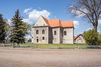
| Description | : | The Church of St. Anne in Konotop (prior to 1945 Kontopp) was first mentioned in 1308. The building was destroyed by a fire in the early 16th century and rebuilt around 1550. Soon after its completion, the church was confiscated by the Protestants, who retained possession of the building until 1654 when the Catholic Church reclaimed the property. In 1706 Kontopp was granted town privileges by Emperor Joseph I, and the church was expanded and remodeled in the Baroque style to reflect this new importance. Beneath the church are three crypts containing the burial sites of the lords of Kontopp, all... Read More |
frequently asked questions (FAQ):
-
Where is Konotop Church of St. Anne?
Konotop Church of St. Anne is located at ul. Kościelna, Konotop Powiat nowosolski ,Lubuskie ,Poland.
-
Konotop Church of St. Anne cemetery's updated grave count on graveviews.com?
0 memorials
-
Where are the coordinates of the Konotop Church of St. Anne?
Latitude: 51.9348543
Longitude: 15.9016898
Nearby Cemetories:
1. Konotop Communal Cemetery
Powiat nowosolski, Poland
Coordinate: 51.9278193, 15.8982824
2. Klenica Communal Cemetery
Powiat zielonogórski, Poland
Coordinate: 51.9915054, 15.7651259
3. Cmentarz Komunalny w Nowej Soli
Powiat nowosolski, Poland
Coordinate: 51.8085928, 15.7220024
4. Cmentarz w Siedlisku
Powiat nowosolski, Poland
Coordinate: 51.7692889, 15.8059587
5. Jany Protestant Cemetery
Zielona Góra, Miasto Zielona Góra, Poland
Coordinate: 51.9753103, 15.5995212
6. Krzepielów Church of St. Martin
Powiat wschowski, Poland
Coordinate: 51.7882136, 16.1068936
7. Rudno Church of St. Simon and St. Jude Thaddeus
Powiat nowosolski, Poland
Coordinate: 51.7848967, 15.6799890
8. Bytom Odrzański Church of St. Jerome
Powiat nowosolski, Poland
Coordinate: 51.7297088, 15.8268909
9. Nowe Kramsko
Powiat zielonogórski, Poland
Coordinate: 52.1380401, 15.7719186
10. Cmentarz Komunalny w Zielonej Górze - Stary
Zielona Góra, Miasto Zielona Góra, Poland
Coordinate: 51.9297180, 15.5360240
11. Cmentarz Komunalny w Zielonej Górze - Nowy
Zielona Góra, Miasto Zielona Góra, Poland
Coordinate: 51.9260572, 15.5328501
12. Studzieniec Communal Cemetery
Zielona Góra, Miasto Zielona Góra, Poland
Coordinate: 51.8009748, 15.5669361
13. Jędrzychów Communal Cemetery
Zielona Góra, Miasto Zielona Góra, Poland
Coordinate: 51.9069430, 15.5018058
14. Dreifaltigkeitsfriedhof (Defunct)
Zielona Góra, Miasto Zielona Góra, Poland
Coordinate: 51.9389998, 15.4928553
15. Solniki Church of St. Anne
Powiat nowosolski, Poland
Coordinate: 51.7193945, 15.6566670
16. Żukowice Church of St. Hedwig
Powiat głogowski, Poland
Coordinate: 51.6711341, 15.9822348
17. Kurów Wielki Church Graveyard
Bolesławiec, Powiat bolesławiecki, Poland
Coordinate: 51.6653100, 15.9095300
18. Kożuchów Old Protestant Cemetery
Zielona Góra, Miasto Zielona Góra, Poland
Coordinate: 51.7433548, 15.5895350
19. Wschowa Old Protestant Cemetery
Powiat wschowski, Poland
Coordinate: 51.8086102, 16.3182998
20. Collegiate church
Glinno, Powiat wałbrzyski, Poland
Coordinate: 51.6704600, 16.0940300
21. Mirocin Górny Communal Cemetery
Zielona Góra, Miasto Zielona Góra, Poland
Coordinate: 51.7541006, 15.5246106
22. Church of Saint Nicolas
Glinno, Powiat wałbrzyski, Poland
Coordinate: 51.6625000, 16.0919440
23. Geyersdorf Friedhof
Powiat wschowski, Poland
Coordinate: 51.8183960, 16.3532140
24. Borów Wielki Church of St. Lawrence
Zielona Góra, Miasto Zielona Góra, Poland
Coordinate: 51.6799688, 15.6320039