
| Memorials | : | 0 |
| Location | : | Schmiedebach, Landkreis Saalfeld-Rudolstädt, Germany |
| Coordinate | : | 50.4906650, 11.4719680 |
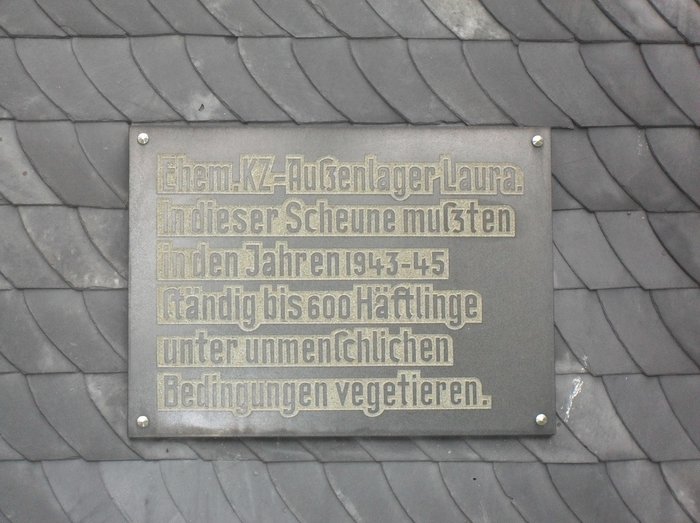
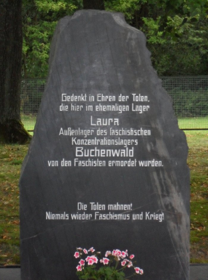
| Description | : | Concentration Camp Laura was a subcamp of Buchenwald Concentration Camp that opened in 1943. The whole area of the former concentration camp is part of the memorial to the Victims of National Socialism and since 2010, a cultural monument of the Thuringian Ministry of Education, Science and Culture. More than 550 people of various nationalities died here. The Camp was liberated by the Allies on April 13, 1945. Just prior to liberation, Camp Guards led those prisoners able to walk on a death march towards Dachau. One of the camp's survivors, Herman van Hasselt, received special permission to have his... Read More |
frequently asked questions (FAQ):
-
Where is KZ Laura?
KZ Laura is located at Schmiedebach, Landkreis Saalfeld-Rudolstadt ,Thüringen ,Germany.
-
KZ Laura cemetery's updated grave count on graveviews.com?
0 memorials
-
Where are the coordinates of the KZ Laura?
Latitude: 50.4906650
Longitude: 11.4719680

Nearby Cemetories:
1. Friedhof Tschirn
Tschirn, Landkreis Kronach, Germany
Coordinate: 50.3995537, 11.4466263
2. Friedhof Windheim Sankt Nikolaus
Windheim, Landkreis Kronach, Germany
Coordinate: 50.4276472, 11.3358444
3. Friedhof Teuschnitz
Teuschnitz, Landkreis Kronach, Germany
Coordinate: 50.3977740, 11.3819410
4. Nordhalben Cemetery
Nordhalben, Landkreis Kronach, Germany
Coordinate: 50.3757727, 11.5117363
5. Friedhof Nordhalben
Nordhalben, Landkreis Kronach, Germany
Coordinate: 50.3757148, 11.5115120
6. Sankt Christophorus
Ebersdorf, Saale-Orla-Kreis, Germany
Coordinate: 50.4852034, 11.6670510
7. Friedhof Grosskamsdorf
Grosskamsdorf, Saale-Orla-Kreis, Germany
Coordinate: 50.6456313, 11.4547378
8. Friedhof Könitz
Unterwellenborn, Landkreis Saalfeld-Rudolstädt, Germany
Coordinate: 50.6536246, 11.4887529
9. Johanneskirche
Saalfeld, Landkreis Saalfeld-Rudolstädt, Germany
Coordinate: 50.6481800, 11.3602500
10. Friedhof Saalfeld
Landkreis Saalfeld-Rudolstädt, Germany
Coordinate: 50.6509860, 11.3462280
11. Friedhof Gräfenwarth
Saale-Orla-Kreis, Germany
Coordinate: 50.5296820, 11.7507200
12. Friedhof Judenbach
Judenbach, Landkreis Sonneberg, Germany
Coordinate: 50.3919380, 11.2198512
13. Schöndorf Friedhof
Schondorf, Saale-Orla-Kreis, Germany
Coordinate: 50.6182343, 11.6945198
14. Krölpaer Friedhof
Krölpa, Saale-Orla-Kreis, Germany
Coordinate: 50.6791650, 11.5325350
15. Lauscha Friedhof
Lauscha, Landkreis Sonneberg, Germany
Coordinate: 50.4785636, 11.1602380
16. Steinach Friedhof
Steinach, Landkreis Sonneberg, Germany
Coordinate: 50.4310116, 11.1553122
17. Neuhaus am Rennweg
Goldisthal, Landkreis Sonneberg, Germany
Coordinate: 50.5154960, 11.1371510
18. Friedhof Sonneberg
Sonneberg, Landkreis Sonneberg, Germany
Coordinate: 50.3631371, 11.1815583
19. Friedhof Oberweißbach
Oberweissbach, Landkreis Saalfeld-Rudolstädt, Germany
Coordinate: 50.5821370, 11.1451600
20. Stadtfriedhof
Hirschberg, Saale-Orla-Kreis, Germany
Coordinate: 50.4115120, 11.8106840
21. Bergfriedhof in Schleiz
Saale-Orla-Kreis, Germany
Coordinate: 50.5832810, 11.8033930
22. Bergkirche St. Marien in Schleiz
Saale-Orla-Kreis, Germany
Coordinate: 50.5842860, 11.8035650
23. Schwarzburg
Schwarzburg, Landkreis Saalfeld-Rudolstädt, Germany
Coordinate: 50.6435690, 11.1958830
24. Stadtkirche Sankt Andreas
Rudolstadt, Landkreis Saalfeld-Rudolstädt, Germany
Coordinate: 50.7220600, 11.3429700