
| Memorials | : | 2 |
| Location | : | Stavanger, Stavanger kommune, Norway |
| Coordinate | : | 58.9640950, 5.7380250 |
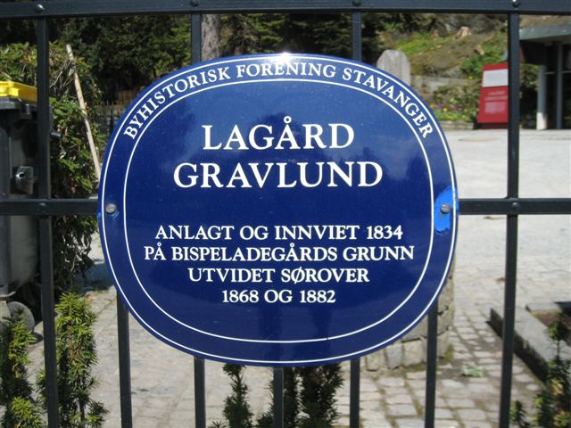
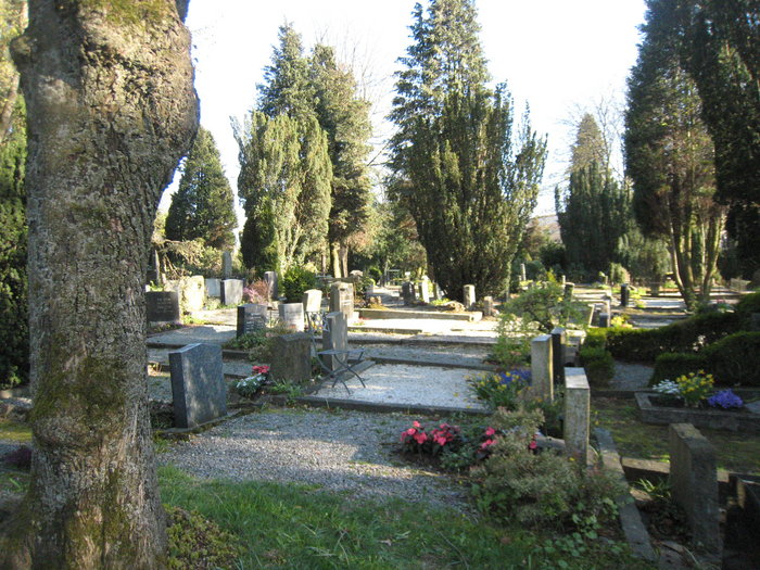
| Description | : | Lagård Cemetery was built and inaugurated in 1834 and the oldest section remains as it was at that time. In 1868 the cemetery was extended south to Cemetery Road. In 1882 it was extended south from Cemetery Road to Paradise and Hillevåg water. It now covers an area of 45,000 m². In 1875, the railway was routed through the southwestern part of the cemetery, and approximately 300 graves were moved. The cemetery is divided into two parts, each side separated by Cemetery Road with a tunnel connecting the two within the cemetery. There are... Read More |
frequently asked questions (FAQ):
-
Where is Lagaard Cemetery?
Lagaard Cemetery is located at Stavanger, Stavanger kommune ,Rogaland fylke ,Norway.
-
Lagaard Cemetery cemetery's updated grave count on graveviews.com?
1 memorials
-
Where are the coordinates of the Lagaard Cemetery?
Latitude: 58.9640950
Longitude: 5.7380250
Nearby Cemetories:
1. Hetland Cemetery
Stavanger, Stavanger kommune, Norway
Coordinate: 58.9680110, 5.7408860
2. Eiganes Churchyard
Stavanger, Stavanger kommune, Norway
Coordinate: 58.9674140, 5.7190720
3. Egenes Kirkegard
Stavanger, Stavanger kommune, Norway
Coordinate: 58.9718000, 5.7220150
4. Tjensvoll Cemetery
Stavanger, Stavanger kommune, Norway
Coordinate: 58.9534480, 5.7094430
5. Hundvaag Kirkegaard
Stavanger, Stavanger kommune, Norway
Coordinate: 58.9972620, 5.7337970
6. Hinna Gravlund
Sandnes, Sandnes kommune, Norway
Coordinate: 58.9222450, 5.7129430
7. Revheim Kirkegaard
Stavanger, Stavanger kommune, Norway
Coordinate: 58.9526990, 5.6443770
8. Grødem Kirke Cemetery
Grodeim, Randaberg kommune, Norway
Coordinate: 59.0089560, 5.6502660
9. Randaberg Church Cemetery
Randaberg, Randaberg kommune, Norway
Coordinate: 58.9997720, 5.6189110
10. Tananger Kirkegaard
Tananger, Sola kommune, Norway
Coordinate: 58.9349660, 5.6009390
11. Tjora Kirkegaard
Sola, Sola kommune, Norway
Coordinate: 58.9072340, 5.6034830
12. Sola Churchyard
Sola, Sola kommune, Norway
Coordinate: 58.8902990, 5.6197140
13. Askje Kirke
Askje, Rennesøy kommune, Norway
Coordinate: 59.0636760, 5.6867740
14. Soma Gravlund
Sandnes, Sandnes kommune, Norway
Coordinate: 58.8603440, 5.7016680
15. Sandnes Nye Cemetery
Sandnes, Sandnes kommune, Norway
Coordinate: 58.8485720, 5.7282690
16. Gand Cemetery
Sandnes, Sandnes kommune, Norway
Coordinate: 58.8450290, 5.7269550
17. Sandnes Gamle Cemetery
Sandnes, Sandnes kommune, Norway
Coordinate: 58.8450100, 5.7273650
18. Østhusvik
Osthusvik, Rennesøy kommune, Norway
Coordinate: 59.0859520, 5.7650760
19. Raege kirke
Sola, Sola kommune, Norway
Coordinate: 58.8553469, 5.6093177
20. Strand kirke
Strand, Strand kommune, Norway
Coordinate: 59.0508750, 5.9308190
21. Høyland Cemetery
Sandnes, Sandnes kommune, Norway
Coordinate: 58.8308000, 5.7498000
22. Talgje Cemetery
Gard, Finnøy kommune, Norway
Coordinate: 59.1064178, 5.8417925
23. Høle Cemetery
Hole, Sandnes kommune, Norway
Coordinate: 58.8965500, 6.0080600
24. Utstein Kloster
Askje, Rennesøy kommune, Norway
Coordinate: 59.1029350, 5.5920310