
| Memorials | : | 1 |
| Location | : | Larned, Pawnee County, USA |
| Coordinate | : | 38.1722800, -99.1566200 |
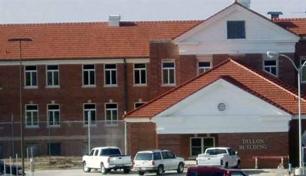
| Description | : | The Old Larned State Mental Hospital has an unmarked cemetery on on the east-side of the Dillon Building. In 1914, the Larned State Hospital was established for the mentally ill in the western part of the state. In 1939, it took on additional responsibilities with the opening of State Security Hospital. Prior to 1960, the Hospital accommodated only adult patients, general psychiatric and forensic; but beginning in 1966, treatment programs were added for children, adolescents, the chemical dependent and security behavior males. Presently the Hospital operates three separate services including Youth, Adult, Security and Security Behavior Services on its ... Read More |
frequently asked questions (FAQ):
-
Where is Larned State Hospital Cemetery?
Larned State Hospital Cemetery is located at 1301 KS-264 Larned, Pawnee County ,Kansas , 67550USA.
-
Larned State Hospital Cemetery cemetery's updated grave count on graveviews.com?
1 memorials
-
Where are the coordinates of the Larned State Hospital Cemetery?
Latitude: 38.1722800
Longitude: -99.1566200
Nearby Cemetories:
1. Larned Cemetery
Larned, Pawnee County, USA
Coordinate: 38.1861000, -99.1333008
2. Fort Larned Cemetery
Larned, Pawnee County, USA
Coordinate: 38.1839100, -99.2163200
3. Pleasant Valley Cemetery
Larned, Pawnee County, USA
Coordinate: 38.0718994, -99.0955963
4. Ash Valley Cemetery
Pawnee County, USA
Coordinate: 38.2905998, -99.2174988
5. Garfield Cemetery
Garfield, Pawnee County, USA
Coordinate: 38.0738983, -99.2667007
6. Fertig Cemetery
Pawnee County, USA
Coordinate: 38.1458015, -98.9492035
7. Pawnee Rock State Historic Site
Pawnee Rock, Barton County, USA
Coordinate: 38.2721800, -98.9815300
8. Pawnee Rock Cemetery
Pawnee Rock, Barton County, USA
Coordinate: 38.2771988, -98.9858017
9. Bergthal Mennonite Cemetery
Pawnee Rock, Barton County, USA
Coordinate: 38.3053017, -98.9772034
10. Point View Cemetery
Pawnee County, USA
Coordinate: 38.1306000, -98.9131012
11. Rozel Cemetery
Rozel, Pawnee County, USA
Coordinate: 38.2042007, -99.4052963
12. Fitch Family Cemetery
Nettleton, Edwards County, USA
Coordinate: 38.0007540, -99.3256550
13. Wayne Cemetery
Lewis, Edwards County, USA
Coordinate: 37.9550018, -99.2144012
14. Belpre Cemetery
Belpre, Edwards County, USA
Coordinate: 37.9528950, -99.1017510
15. Peace Lutheran Cemetery
Timken, Rush County, USA
Coordinate: 38.3837600, -99.0330750
16. Pleasant Ridge Cemetery
Radium, Stafford County, USA
Coordinate: 38.2475014, -98.8758011
17. Saint Pauls Lutheran Cemetery
Albert, Barton County, USA
Coordinate: 38.3770000, -99.0005900
18. Peace Lutheran Cemetery
Kinsley, Edwards County, USA
Coordinate: 38.0285988, -99.4047012
19. Dundee Valley Cemetery
Great Bend, Barton County, USA
Coordinate: 38.3125130, -98.8778980
20. Patterson Cemetery
Barton County, USA
Coordinate: 38.4019012, -98.9963989
21. Salem Cemetery
Edwards County, USA
Coordinate: 38.0331001, -99.4421997
22. Farmington Cemetery
Macksville, Stafford County, USA
Coordinate: 37.9574510, -98.9608270
23. Township Cemetery
Macksville, Stafford County, USA
Coordinate: 37.9569016, -98.9582977
24. Saint Francis Xavier Cemetery
Seward, Stafford County, USA
Coordinate: 38.2038994, -98.8193970