
| Memorials | : | 248 |
| Location | : | Larned, Pawnee County, USA |
| Coordinate | : | 38.0718994, -99.0955963 |
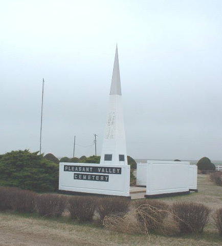
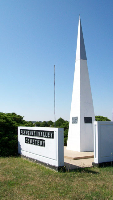
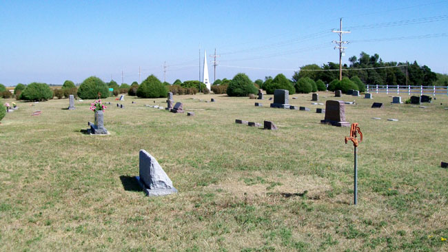
| Description | : | The Pleasant Valley Cemetery is located approximately seven miles south of Larned, Pawnee County, Kansas on K -19 Highway, on the northeast corner of Section 8, Township 23, Range 16 West from the principal Meridian, and consists of a tract of land measuring three and three Fourth's acres. This cemetery is in what is known as the Zook Community of Pawnee Co., Kansas. Pleasant Valley Cemetery is also know as Pratt Cemetery and Zook Cemetery. According to Pawnee County Cemetery clerk, Pleasant Valley is the correct name. |
frequently asked questions (FAQ):
-
Where is Pleasant Valley Cemetery?
Pleasant Valley Cemetery is located at Larned, Pawnee County ,Kansas ,USA.
-
Pleasant Valley Cemetery cemetery's updated grave count on graveviews.com?
243 memorials
-
Where are the coordinates of the Pleasant Valley Cemetery?
Latitude: 38.0718994
Longitude: -99.0955963
Nearby Cemetories:
1. Larned State Hospital Cemetery
Larned, Pawnee County, USA
Coordinate: 38.1722800, -99.1566200
2. Larned Cemetery
Larned, Pawnee County, USA
Coordinate: 38.1861000, -99.1333008
3. Belpre Cemetery
Belpre, Edwards County, USA
Coordinate: 37.9528950, -99.1017510
4. Garfield Cemetery
Garfield, Pawnee County, USA
Coordinate: 38.0738983, -99.2667007
5. Fertig Cemetery
Pawnee County, USA
Coordinate: 38.1458015, -98.9492035
6. Fort Larned Cemetery
Larned, Pawnee County, USA
Coordinate: 38.1839100, -99.2163200
7. Wayne Cemetery
Lewis, Edwards County, USA
Coordinate: 37.9550018, -99.2144012
8. Point View Cemetery
Pawnee County, USA
Coordinate: 38.1306000, -98.9131012
9. Farmington Cemetery
Macksville, Stafford County, USA
Coordinate: 37.9574510, -98.9608270
10. Township Cemetery
Macksville, Stafford County, USA
Coordinate: 37.9569016, -98.9582977
11. Fitch Family Cemetery
Nettleton, Edwards County, USA
Coordinate: 38.0007540, -99.3256550
12. Pawnee Rock State Historic Site
Pawnee Rock, Barton County, USA
Coordinate: 38.2721800, -98.9815300
13. Pawnee Rock Cemetery
Pawnee Rock, Barton County, USA
Coordinate: 38.2771988, -98.9858017
14. Ash Valley Cemetery
Pawnee County, USA
Coordinate: 38.2905998, -99.2174988
15. Devore Family Cemetery
St. John, Stafford County, USA
Coordinate: 38.0141200, -98.7947700
16. Pleasant Ridge Cemetery
Radium, Stafford County, USA
Coordinate: 38.2475014, -98.8758011
17. Peace Lutheran Cemetery
Kinsley, Edwards County, USA
Coordinate: 38.0285988, -99.4047012
18. Neelands Cemetery
St. John, Stafford County, USA
Coordinate: 37.9000015, -98.8660965
19. Bergthal Mennonite Cemetery
Pawnee Rock, Barton County, USA
Coordinate: 38.3053017, -98.9772034
20. Prattsburg Cemetery
Macksville, Stafford County, USA
Coordinate: 37.8283005, -99.0044022
21. Saint Francis Xavier Cemetery
Seward, Stafford County, USA
Coordinate: 38.2038994, -98.8193970
22. Fellsburg Cemetery
Edwards County, USA
Coordinate: 37.8069000, -99.1688995
23. Trotter Cemetery
Lewis, Edwards County, USA
Coordinate: 37.8394012, -99.2780991
24. Salem Cemetery
Edwards County, USA
Coordinate: 38.0331001, -99.4421997