| Memorials | : | 5 |
| Location | : | Moorefield, Independence County, USA |
| Coordinate | : | 35.7908740, -91.5662810 |
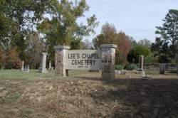
| Description | : | LEE'S CHAPEL CEMETERY (Moorefield) There are two Lee's Chapel Cemeteries in Independence County--one is on Sandtown Road--this one is located on Hwy 25. It is the cemetery connected with Lee's Chapel Methodist Church, which congregated close to this location from 1871 until 1921, when it moved to Moorefield. The cemetery is a half mile from the Hwy 233 junction (which connects Hwy 25 to Hwy 69) going toward Charlotte. |
frequently asked questions (FAQ):
-
Where is Lees Chapel Cemetery?
Lees Chapel Cemetery is located at Moorefield, Independence County ,Arkansas ,USA.
-
Lees Chapel Cemetery cemetery's updated grave count on graveviews.com?
5 memorials
-
Where are the coordinates of the Lees Chapel Cemetery?
Latitude: 35.7908740
Longitude: -91.5662810
Nearby Cemetories:
1. Rehobeth Cemetery
Moorefield, Independence County, USA
Coordinate: 35.7806560, -91.5717960
2. Independence County Poor Farm
Independence County, USA
Coordinate: 35.7801055, -91.5707189
3. Mack Family Cemetery
Batesville, Independence County, USA
Coordinate: 35.7977676, -91.5819473
4. Mount Zion Cemetery
Batesville, Independence County, USA
Coordinate: 35.8008003, -91.5986023
5. Stark Cemetery
Moorefield, Independence County, USA
Coordinate: 35.7827988, -91.5994034
6. Saint Mary's Parish Columbarium
Batesville, Independence County, USA
Coordinate: 35.7678940, -91.5961580
7. Sanders Cemetery
Moorefield, Independence County, USA
Coordinate: 35.7560997, -91.5402985
8. Roselawn Memorial Gardens
Batesville, Independence County, USA
Coordinate: 35.8074390, -91.6145550
9. Haddock Cemetery
Independence County, USA
Coordinate: 35.8074989, -91.5132980
10. Rutherford Family Cemetery
Batesville, Independence County, USA
Coordinate: 35.7361320, -91.5701870
11. Bethel Cemetery
Independence County, USA
Coordinate: 35.8339005, -91.5214005
12. Oaklawn Cemetery
Batesville, Independence County, USA
Coordinate: 35.7649994, -91.6350021
13. Thornsberry A Gray Cemetery
Batesville, Independence County, USA
Coordinate: 35.7639391, -91.6378059
14. Weavers Chapel Cemetery
Batesville, Independence County, USA
Coordinate: 35.8608017, -91.5710983
15. Saint Paul Episcopal Church Columbarium
Batesville, Independence County, USA
Coordinate: 35.7718750, -91.6503550
16. Pioneer Cemetery
Batesville, Independence County, USA
Coordinate: 35.7706680, -91.6514200
17. Cave Creek Cemetery
Pfeiffer, Independence County, USA
Coordinate: 35.8483000, -91.6233300
18. Johnson Cemetery
Independence County, USA
Coordinate: 35.7924995, -91.6583023
19. Belleview Cemetery
Independence County, USA
Coordinate: 35.8302994, -91.6483002
20. Chinn Cemetery
Independence County, USA
Coordinate: 35.8422012, -91.6386032
21. Allen Chapel Freewill Baptist Church Cemetery
Batesville, Independence County, USA
Coordinate: 35.7275330, -91.6281060
22. New Hope Cemetery
Bethesda, Independence County, USA
Coordinate: 35.7750664, -91.6707764
23. Greenfield Cemetery
Independence County, USA
Coordinate: 35.8269005, -91.6660995
24. Egner Cemetery
Salado, Independence County, USA
Coordinate: 35.7083015, -91.6108017


