
| Memorials | : | 13 |
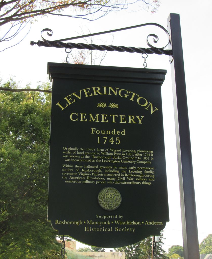
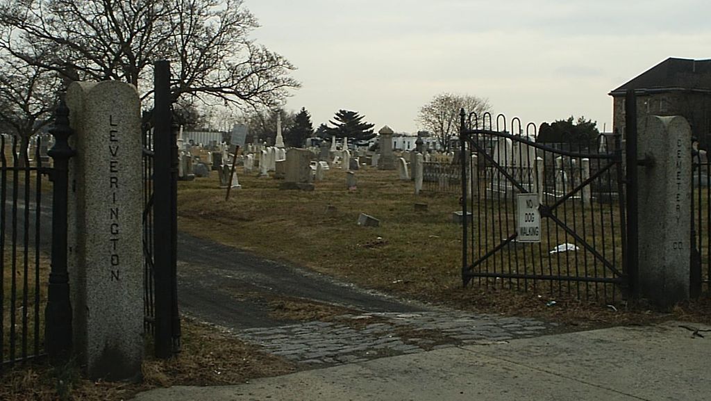
| Location | : | Roxborough, Philadelphia County, USA |
| Phone | : | 215-482-1489 |
| Coordinate | : | 40.0335999, -75.2118988 |
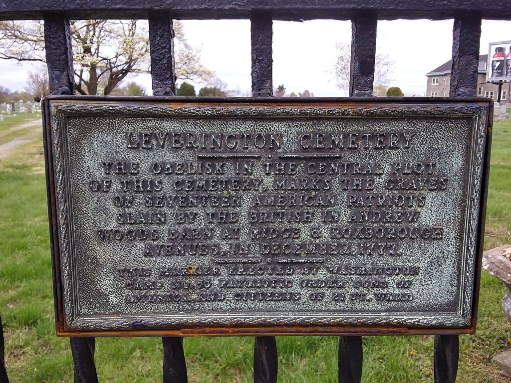
| Description | : | The adjoining Roxborough Baptist Church Yard is not separated from Leverington by any border or boundary; hence the two may be co-mingled in Leverington Cemetery. The Roxborough Baptist Church Cemetery was closed in the 1980s. Those burials are obviously near the church building which still remains. |
frequently asked questions (FAQ):
-
Where is Leverington Cemetery?
Leverington Cemetery is located at Ridge Avenue and Lyceum Avenue Roxborough, Philadelphia County ,Pennsylvania ,USA.
-
Leverington Cemetery cemetery's updated grave count on graveviews.com?
12 memorials
-
Where are the coordinates of the Leverington Cemetery?
Latitude: 40.0335999
Longitude: -75.2118988
Nearby Cemetories:
1. Bethany German Lutheran Cemetery
Manayunk, Philadelphia County, USA
Coordinate: 40.0301208, -75.2170715
2. Saint Timothys Episcopal Church Cemetery
Roxborough, Philadelphia County, USA
Coordinate: 40.0275230, -75.2107315
3. Fourth Reformed Churchyard (Defunct)
Philadelphia, Philadelphia County, USA
Coordinate: 40.0262720, -75.2213970
4. Saint John the Baptist Catholic Church Cemetery
Manayunk, Philadelphia County, USA
Coordinate: 40.0250282, -75.2195282
5. Saint Mary of the Assumption Cemetery
Roxborough, Philadelphia County, USA
Coordinate: 40.0382996, -75.2268982
6. Kelphius Memorial
Germantown, Philadelphia County, USA
Coordinate: 40.0237730, -75.2015340
7. Saint Davids Protestant Episcopal Churchyard
Manayunk, Philadelphia County, USA
Coordinate: 40.0288467, -75.2272415
8. Church of Saint Alban Memorial Garden
Roxborough, Philadelphia County, USA
Coordinate: 40.0423160, -75.2247540
9. First Presbyterian Church Grounds
Manayunk, Philadelphia County, USA
Coordinate: 40.0283430, -75.2280010
10. Westminster Cemetery
Bala Cynwyd, Montgomery County, USA
Coordinate: 40.0219002, -75.2285995
11. West Laurel Hill Cemetery
Bala Cynwyd, Montgomery County, USA
Coordinate: 40.0140170, -75.2277120
12. Upper Burial Grounds
Germantown, Philadelphia County, USA
Coordinate: 40.0440000, -75.1811000
13. Germantown Mennonite Cemetery
Germantown, Philadelphia County, USA
Coordinate: 40.0413971, -75.1789932
14. Germantown Church of the Brethren Cemetery
Germantown, Philadelphia County, USA
Coordinate: 40.0496101, -75.1840820
15. Saint Michaels Lutheran Churchyard
Germantown, Philadelphia County, USA
Coordinate: 40.0517044, -75.1850204
16. Haines Street Methodist Cemetery
Germantown, Philadelphia County, USA
Coordinate: 40.0393370, -75.1763230
17. Polite Temple Baptist Churchyard
Philadelphia County, USA
Coordinate: 40.0373198, -75.1745654
18. Saint Vincent de Paul Catholic Church Grounds
Germantown, Philadelphia County, USA
Coordinate: 40.0378854, -75.1743803
19. Merion Memorial Park
Bala Cynwyd, Montgomery County, USA
Coordinate: 40.0167694, -75.2428818
20. Germantown Potter's Field
Germantown, Philadelphia County, USA
Coordinate: 40.0263188, -75.1747099
21. Germantown Preparatory Meeting of Friends Cemetery
Germantown, Philadelphia County, USA
Coordinate: 40.0319672, -75.1722794
22. Market Square Presbyterian Church Cemetery
Germantown, Philadelphia County, USA
Coordinate: 40.0340700, -75.1722200
23. Saint Luke's Episcopal Churchyard
Germantown, Philadelphia County, USA
Coordinate: 40.0336533, -75.1709671
24. Church of Saint Martin-in-the-Fields Columbarium
Philadelphia, Philadelphia County, USA
Coordinate: 40.0653650, -75.2066780