
| Memorials | : | 2 |
| Location | : | Rutherford County, USA |
| Coordinate | : | 35.3229870, -81.9340790 |
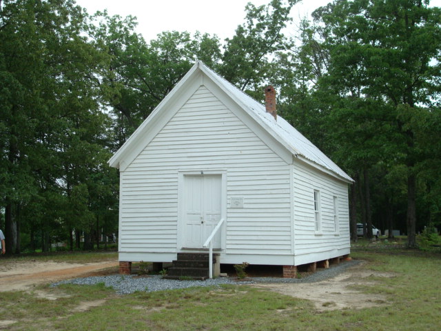
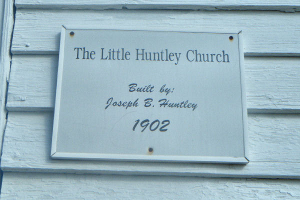
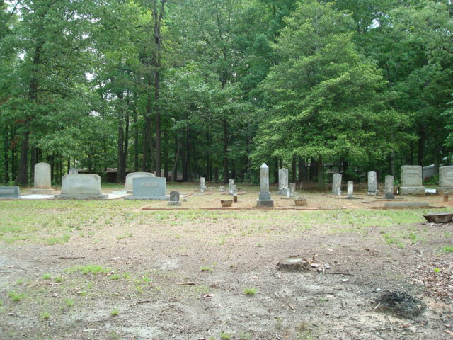
| Description | : | The church building was built in 1902 by Joseph B Huntley. The church members now meet once a year on the first Sunday in June. Located SE of the intersection of Dunkard Church Rd., SR2196, and 221, near the intersection of Poors Ford Road. The David Huntley Family Cemetery is located on Poors Ford RD. .2 mile East of the Poors Ford Rd./ 221 intersection. |
frequently asked questions (FAQ):
-
Where is Little Huntley Church Cemetery?
Little Huntley Church Cemetery is located at Rutherford County ,North Carolina ,USA.
-
Little Huntley Church Cemetery cemetery's updated grave count on graveviews.com?
2 memorials
-
Where are the coordinates of the Little Huntley Church Cemetery?
Latitude: 35.3229870
Longitude: -81.9340790
Nearby Cemetories:
1. David Huntley Family Cemetery
Rutherfordton, Rutherford County, USA
Coordinate: 35.3255330, -81.9347790
2. Restoration Church Cemetery
Forest City, Rutherford County, USA
Coordinate: 35.3328200, -81.9228500
3. Adaville Baptist Church Cemetery
Spindale, Rutherford County, USA
Coordinate: 35.3356680, -81.9201110
4. Sunset Memorial Park
Forest City, Rutherford County, USA
Coordinate: 35.3200800, -81.9088050
5. Mountain View Baptist Church Cemetery
Rutherfordton, Rutherford County, USA
Coordinate: 35.3323070, -81.9591380
6. Shiloh Baptist Cemetery
Shiloh, Rutherford County, USA
Coordinate: 35.2975160, -81.9424070
7. Spindale Cemetery
Spindale, Rutherford County, USA
Coordinate: 35.3507996, -81.9218979
8. Danieltown Baptist Church Cemetery
Danieltown, Rutherford County, USA
Coordinate: 35.2977100, -81.9127880
9. Spindale Fellowship Holiness Church Cemetery
Spindale, Rutherford County, USA
Coordinate: 35.3544971, -81.9410039
10. Word of Faith Fellowship Cemetery
Spindale, Rutherford County, USA
Coordinate: 35.2931390, -81.9189950
11. Leawood Drive Cemetery
Rutherfordton, Rutherford County, USA
Coordinate: 35.2928150, -81.9527720
12. Russell Tabernacle CME Church Memorial Garden
Spindale, Rutherford County, USA
Coordinate: 35.3587510, -81.9164120
13. Bethany Baptist Church Cemetery
Forest City, Rutherford County, USA
Coordinate: 35.3029200, -81.8933260
14. Tanners Grove United Methodist Cemetery
Rutherford County, USA
Coordinate: 35.2905410, -81.9049720
15. McDonald Family Cemetery
Forest City, Rutherford County, USA
Coordinate: 35.3075850, -81.8876240
16. Whiteside Cemetery
Spindale, Rutherford County, USA
Coordinate: 35.3605400, -81.9118200
17. Saint Paul AME Zion Cemetery
Forest City, Rutherford County, USA
Coordinate: 35.3407600, -81.8863900
18. Wells Springs UMC Cemetery
Forest City, Rutherford County, USA
Coordinate: 35.3485413, -81.8906326
19. West Point Baptist Church Cemetery
Rutherford County, USA
Coordinate: 35.3282480, -81.9893440
20. Oak Grove Missionary Baptist Church
Forest City, Rutherford County, USA
Coordinate: 35.3296300, -81.8782300
21. Grays Creek Baptist Church Cemetery
Shiloh, Rutherford County, USA
Coordinate: 35.2854652, -81.9674301
22. Sulphur Springs Holiness Cemetery
Danieltown, Rutherford County, USA
Coordinate: 35.2844250, -81.9004050
23. Union Cemetery
Rutherford County, USA
Coordinate: 35.3157997, -81.9922028
24. Pleasant Grove United Methodist Church Cemetery
Forest City, Rutherford County, USA
Coordinate: 35.3490000, -81.8845000