
| Memorials | : | 0 |
| Location | : | Warwick, Kent County, USA |
| Coordinate | : | 41.7118912, -71.4039078 |
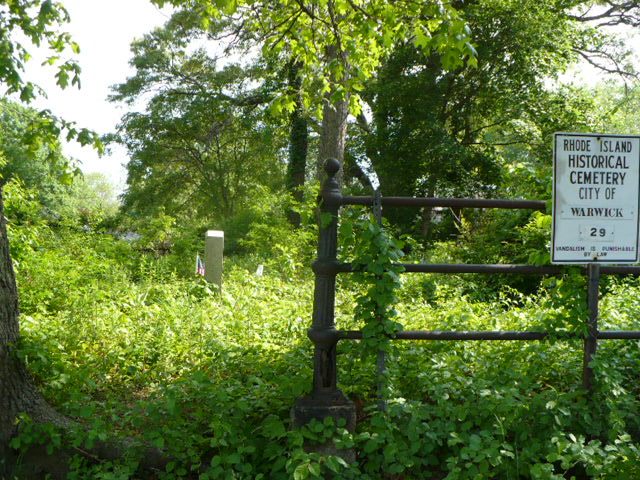
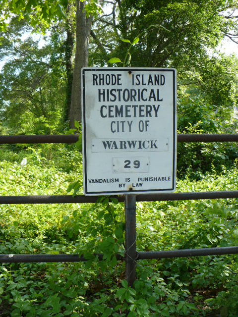
| Description | : | Large lot located on the southwest corner of Social Drive and Crane Street, just north of Sandy Lane and the Warwick Public Library. The sign for the lot is located around the right side of the lot at an opening caused by the growth of a large maple tree. The lot has a gate at the front and is surrounded by an iron fence. It has a few trees and still has a blanket of dead leaves and a foot of growth covering the ground. The sign reads that the cemetery is #29 when in... Read More |
frequently asked questions (FAQ):
-
Where is Lockwood-Phillips Lot?
Lockwood-Phillips Lot is located at Warwick, Kent County ,Rhode Island ,USA.
-
Lockwood-Phillips Lot cemetery's updated grave count on graveviews.com?
0 memorials
-
Where are the coordinates of the Lockwood-Phillips Lot?
Latitude: 41.7118912
Longitude: -71.4039078
Nearby Cemetories:
1. Benajah Lockwood Lot
Warwick, Kent County, USA
Coordinate: 41.7119293, -71.4059753
2. Hart Lot
Warwick, Kent County, USA
Coordinate: 41.7135710, -71.3998830
3. Joseph Horr Lot
Warwick, Kent County, USA
Coordinate: 41.7113890, -71.4108890
4. Amos Lockwood Lot
Warwick, Kent County, USA
Coordinate: 41.7141876, -71.3965073
5. Lincoln Family Lot
Warwick, Kent County, USA
Coordinate: 41.7090111, -71.4119034
6. Briggs-Stone Lot
Warwick, Kent County, USA
Coordinate: 41.7139244, -71.3949890
7. Briggs Lot
Warwick, Kent County, USA
Coordinate: 41.7131691, -71.3928986
8. Colonel John Low Lot
Warwick, Kent County, USA
Coordinate: 41.7017850, -71.3977870
9. Colonel John Waterman Lot
Warwick, Kent County, USA
Coordinate: 41.7218018, -71.3965912
10. Captain John Low Burial Ground (Defunct)
Warwick, Kent County, USA
Coordinate: 41.7014990, -71.3956940
11. Lippitt Burial Ground
Warwick, Kent County, USA
Coordinate: 41.7049090, -71.4174200
12. Christopher Spencer Lot
Warwick, Kent County, USA
Coordinate: 41.7032900, -71.3867400
13. Elder Charles Holden Lot
Warwick, Kent County, USA
Coordinate: 41.6975280, -71.3957220
14. Friends Burial Yard
Warwick, Kent County, USA
Coordinate: 41.7030030, -71.3866420
15. Abraham Lockwood Lot
Warwick, Kent County, USA
Coordinate: 41.7155280, -71.4244440
16. James Budlong Lot
Warwick, Kent County, USA
Coordinate: 41.7023610, -71.4216670
17. Greene Lot
Warwick, Kent County, USA
Coordinate: 41.7034683, -71.3837891
18. Greene Lot
Warwick, Kent County, USA
Coordinate: 41.6967270, -71.3912590
19. Captain Randall Holden Jr. Lot
Warwick, Kent County, USA
Coordinate: 41.6991500, -71.3858700
20. Carder Lot
Warwick, Kent County, USA
Coordinate: 41.6952240, -71.3916750
21. Christopher Greene Lot
Warwick, Kent County, USA
Coordinate: 41.7314606, -71.3957367
22. Austin-Card Lot
Warwick, Kent County, USA
Coordinate: 41.7330246, -71.4032974
23. Governor Samuel Gorton Lot
Warwick, Kent County, USA
Coordinate: 41.6998940, -71.3789673
24. Greene Lot
Warwick, Kent County, USA
Coordinate: 41.7283710, -71.3838880