
| Memorials | : | 0 |
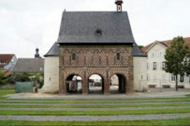
| Location | : | Lorsch, Kreis Bergstraße, Germany |
| Coordinate | : | 49.6538750, 8.5691850 |
| Description | : | Founded in 764, by Count Cancor and his widowed mother, Williswinda, and dedicated to Saints Peter and Paul, it is one of the most renowned monasteries of the Carolingian Empire. On 11 July 765, sacred relics arrived, and with great solemnity were deposited in the basilica of the monastery. In 772, the abbey and basilica were then renamed in honour of Saint Nazarius: the main church of Saints Peter, Paul, and Nazarius was consecrated by the Archbishop of Mainz in September 774, in the presence of Charlemagne. Many miracles were said to be wrought through the intercession of Saint Nazarius... Read More |
frequently asked questions (FAQ):
-
Where is Lorsch Abbey?
Lorsch Abbey is located at Lorsch, Kreis Bergstraße ,Hessen ,Germany.
-
Lorsch Abbey cemetery's updated grave count on graveviews.com?
0 memorials
-
Where are the coordinates of the Lorsch Abbey?
Latitude: 49.6538750
Longitude: 8.5691850
Nearby Cemetories:
1. Kloster Lorsch
Lorsch, Kreis Bergstraße, Germany
Coordinate: 49.6538890, 8.5688890
2. Friedhof-Mitte
Bensheim, Kreis Bergstraße, Germany
Coordinate: 49.6763922, 8.6246400
3. Friedhof Stadt Heppenheim
Heppenheim an der Bergstrasse, Kreis Bergstraße, Germany
Coordinate: 49.6366490, 8.6454490
4. Waldfriedhof Bensheim
Bensheim, Kreis Bergstraße, Germany
Coordinate: 49.6812540, 8.6393906
5. Friedhof Stadt Heppenheim
Heppenheim an der Bergstrasse, Kreis Bergstraße, Germany
Coordinate: 49.6333646, 8.6478892
6. Friedhof Huettenfeld Lampertheim
Kreis Bergstraße, Germany
Coordinate: 49.5987050, 8.5886480
7. Bergfriedhof Auerbach
Auerbach, Kreis Bergstraße, Germany
Coordinate: 49.7019862, 8.6265501
8. Friedhof Langwaden
Bensheim, Kreis Bergstraße, Germany
Coordinate: 49.7174623, 8.5524740
9. Friedhof Laudenbach
Laudenbach, Rhein-Neckar-Kreis, Germany
Coordinate: 49.6158300, 8.6524100
10. Waldfriedhof Lampertheim
Kreis Bergstraße, Germany
Coordinate: 49.5999520, 8.5061320
11. Lampertheim Waldfriedhof
Lampertheim, Kreis Bergstraße, Germany
Coordinate: 49.5989380, 8.5032680
12. Friedhof Zwingenberg
Zwingenberg, Kreis Bergstraße, Germany
Coordinate: 49.7268869, 8.6140628
13. Stadtfriedhof Lampertheim
Kreis Bergstraße, Germany
Coordinate: 49.5956460, 8.4768960
14. Friedhof Hähnlein
Alsbach-Hahnlein, Landkreis Darmstadt-Dieburg, Germany
Coordinate: 49.7379628, 8.5818973
15. Friedhof Bobstadt
Kreis Bergstraße, Germany
Coordinate: 49.6629290, 8.4369640
16. Friedhof Stadt Hemsbach
Hemsbach, Rhein-Neckar-Kreis, Germany
Coordinate: 49.5873949, 8.6548724
17. Jüdischer Friedhof Hemsbach
Hemsbach, Rhein-Neckar-Kreis, Germany
Coordinate: 49.5934100, 8.6718900
18. Friedhof Sulzbach
Weinheim, Rhein-Neckar-Kreis, Germany
Coordinate: 49.5819909, 8.6582973
19. Friedhof Hofheim Lampertheim
Kreis Bergstraße, Germany
Coordinate: 49.6606100, 8.4124160
20. Hauptfriedhof Weinheim
Weinheim, Rhein-Neckar-Kreis, Germany
Coordinate: 49.5692327, 8.6645942
21. Friedhof Rimbach
Rimbach, Kreis Bergstraße, Germany
Coordinate: 49.6561300, 8.7346300
22. Friedhof Knoden
Kreis Bergstraße, Germany
Coordinate: 49.6933041, 8.7234265
23. Friedhof Lorscher Strasse in Viernheim
Kreis Bergstraße, Germany
Coordinate: 49.5453290, 8.5779080
24. Friedhof Mannheim Gartenstadt
Mannheim, Stadtkreis Mannheim, Germany
Coordinate: 49.5362300, 8.4943500