
| Memorials | : | 9 |
| Location | : | Malmö, Malmö kommun, Sweden |
| Coordinate | : | 55.6023100, 13.0186500 |
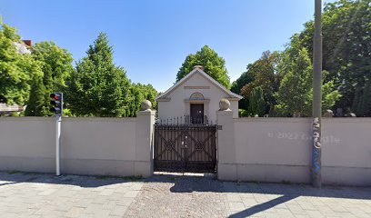
| Description | : | The cemetery is located at the junction between the Foreningsgaten and the Industrigaten, and forms part of the Pauli Norra Kyrkogard. The Jewish Cemetery is contained within the walled enclosure, the entrance to which is through the gate a few metres from the road junction. From the gate proceed to the memorial at the rear of the cemetery to those killed in the concentration camps. The Commonwealth graves are marked by private memorials. Malmo Jewish Cemetery contains the graves of two Commonwealth airmen of the Second World War. |
frequently asked questions (FAQ):
-
Where is Malmo Jewish Cemetery?
Malmo Jewish Cemetery is located at Malmö, Malmö kommun ,Skåne län ,Sweden.
-
Malmo Jewish Cemetery cemetery's updated grave count on graveviews.com?
9 memorials
-
Where are the coordinates of the Malmo Jewish Cemetery?
Latitude: 55.6023100
Longitude: 13.0186500
Nearby Cemetories:
1. Sankt Pauli Mellersta Kyrkogård
Malmö, Malmö kommun, Sweden
Coordinate: 55.5976730, 13.0202500
2. Östra Kyrkogården
Malmö, Malmö kommun, Sweden
Coordinate: 55.5936110, 13.0452780
3. Hyllie kyrkogård
Malmö kommun, Sweden
Coordinate: 55.5663535, 12.9632980
4. Limhamns Kyrkogård
Malmö, Malmö kommun, Sweden
Coordinate: 55.5726990, 12.9453440
5. Arrie Kyrkogård
Vellinge, Vellinge kommun, Sweden
Coordinate: 55.5153062, 13.0848378
6. Hököpinge Gamla Kyrkogård
Vellinge, Vellinge kommun, Sweden
Coordinate: 55.5025990, 13.0297430
7. Gessie Gamla Kyrkogård
Vellinge, Vellinge kommun, Sweden
Coordinate: 55.5018556, 12.9968000
8. Hököpinge Nya Kyrkogård
Vellinge, Vellinge kommun, Sweden
Coordinate: 55.5013195, 13.0323886
9. Gessie Nya Kyrkogård
Gessie, Vellinge kommun, Sweden
Coordinate: 55.5017280, 12.9882270
10. Bara Kyrkogård
Svedala kommun, Sweden
Coordinate: 55.5909233, 13.2014502
11. Bara Ödekyrkogård
Svedala kommun, Sweden
Coordinate: 55.5909945, 13.2017832
12. Uppåkra Kyrkogård
Lilla Uppakra, Staffanstorps kommun, Sweden
Coordinate: 55.6610140, 13.1855162
13. Sankt Lars
Lund, Lunds kommun, Sweden
Coordinate: 55.6817900, 13.1676700
14. Södra Åkarp Kyrkogård
Sodra Akarp, Vellinge kommun, Sweden
Coordinate: 55.4840714, 13.0510117
15. Eskilstorps Kyrkogård
Vellinge, Vellinge kommun, Sweden
Coordinate: 55.4804669, 13.0234034
16. Västra Ingelstads Kyrkogård
Vellinge, Vellinge kommun, Sweden
Coordinate: 55.4902806, 13.1160125
17. Västra Ingelstad Nya Kyrkogård
Vellinge, Vellinge kommun, Sweden
Coordinate: 55.4903817, 13.1168721
18. Västra Ingelstad Gamla Kyrkogård
Vastra Ingelstad, Vellinge kommun, Sweden
Coordinate: 55.4903430, 13.1168530
19. Vellinge Nya Kyrkogård
Vellinge, Vellinge kommun, Sweden
Coordinate: 55.4655504, 13.0196800
20. Mellan-Grevie Kyrkogård
Mellan-Grevie, Vellinge kommun, Sweden
Coordinate: 55.4700912, 13.0970274
21. Lunds Östra kyrkogård
Lund, Lunds kommun, Sweden
Coordinate: 55.6990000, 13.2016000
22. Stora Råby kyrkogård
Lunds kommun, Sweden
Coordinate: 55.6859377, 13.2250434
23. Östra Grevie Kyrkogård
Ostra Grevie, Vellinge kommun, Sweden
Coordinate: 55.4690915, 13.1349324
24. Lund Northern Cemetery
Lund, Lunds kommun, Sweden
Coordinate: 55.7145400, 13.1926900