
| Memorials | : | 1 |
| Location | : | Ripon, Harrogate Borough, England |
| Coordinate | : | 54.1016080, -1.5510380 |
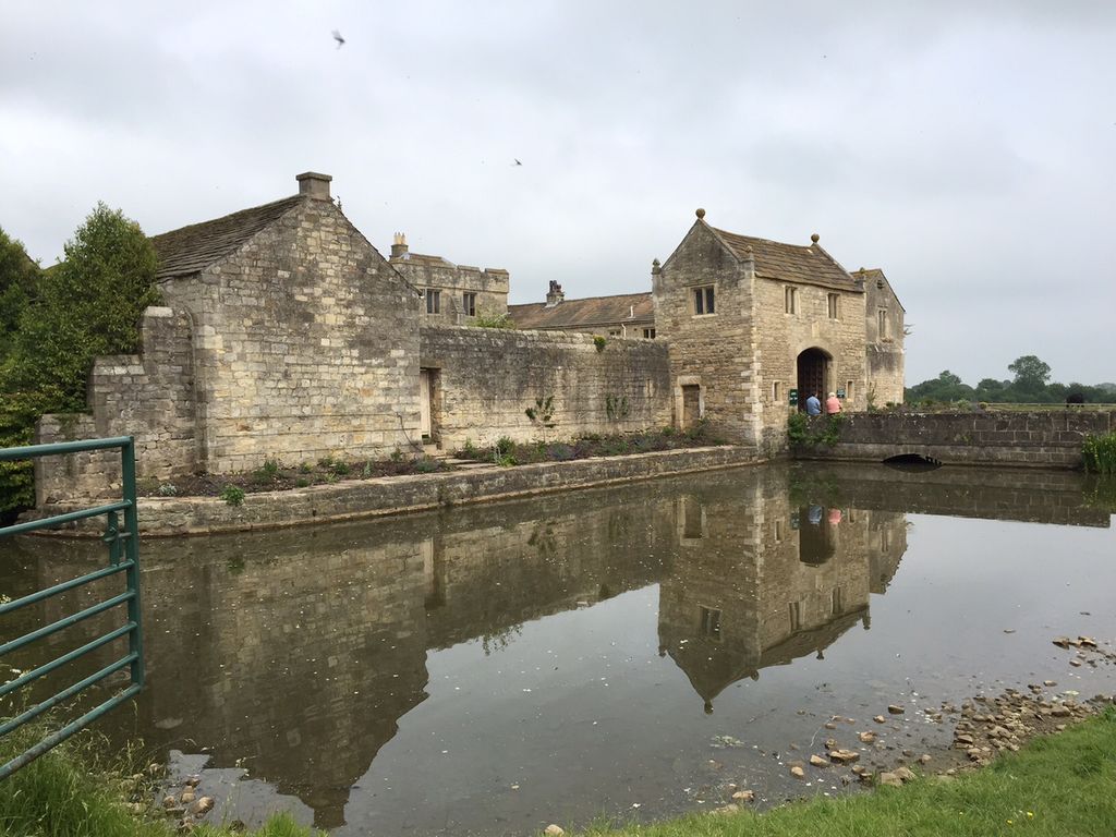
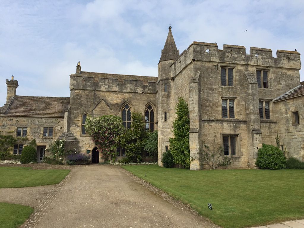
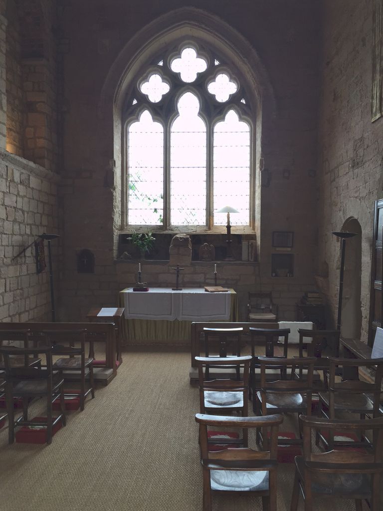
| Description | : | Markenfield Hall is an early 14th-century moated country house three miles (5 km) south of Ripon, North Yorkshire, England in the civil parish of Markingfield Hall. It is one of the finest surviving English country houses from that time. The house is an L-shaped castellated block, with a great hall that stands upon an undercroft and was originally reached by an exterior stone staircase. It is lit by two double-light windows with quatrefoil transom under their arched heads. Markenfield was mentioned in the Domesday Book in 1086, when there were two households. In 1150 the estate belonged to the Le Bret family who... Read More |
frequently asked questions (FAQ):
-
Where is Markenfield Hall?
Markenfield Hall is located at Ripon, Harrogate Borough ,North Yorkshire , HG4 3ADEngland.
-
Markenfield Hall cemetery's updated grave count on graveviews.com?
1 memorials
-
Where are the coordinates of the Markenfield Hall?
Latitude: 54.1016080
Longitude: -1.5510380
Nearby Cemetories:
1. Fountains Abbey
Fountains Abbey, Harrogate Borough, England
Coordinate: 54.1097220, -1.5813890
2. St. Michael the Archangel Churchyard
Markington, Harrogate Borough, England
Coordinate: 54.0807600, -1.5636610
3. St. Mary's Churchyard
Studley Royal, Harrogate Borough, England
Coordinate: 54.1187000, -1.5801000
4. St. Lawrence the Martyr Churchyard
Aldfield, Harrogate Borough, England
Coordinate: 54.1203920, -1.5947810
5. St. John the Baptist Churchyard
Bishop Monkton, Harrogate Borough, England
Coordinate: 54.0885430, -1.4988680
6. Ripon Cathedral
Ripon, Harrogate Borough, England
Coordinate: 54.1349487, -1.5255010
7. Holy Trinity Churchyard
Ripon, Harrogate Borough, England
Coordinate: 54.1378700, -1.5283900
8. St Wilfrid Churchyard
South Stainley, Harrogate Borough, England
Coordinate: 54.0636650, -1.5327810
9. Temple Gardens
Ripon, Harrogate Borough, England
Coordinate: 54.1386070, -1.5229240
10. St Michael and All Angels Churchyard
Sawley, Harrogate Borough, England
Coordinate: 54.1048910, -1.6202810
11. Ripon Cemetery
Ripon, Harrogate Borough, England
Coordinate: 54.1418130, -1.5357040
12. St Leonard Churchyard
Burton Leonard, Harrogate Borough, England
Coordinate: 54.0697660, -1.5005160
13. Lark Hill Cemetery
Ripon, Harrogate Borough, England
Coordinate: 54.1454600, -1.5422800
14. St John the Evangelist Church of England
Bishop Thornton, Harrogate Borough, England
Coordinate: 54.0672100, -1.5991650
15. St Joseph Roman Catholic Churchyard
Bishop Thornton, Harrogate Borough, England
Coordinate: 54.0655250, -1.6023280
16. St. Cuthbert and St. Oswald Churchyard
Winksley, Harrogate Borough, England
Coordinate: 54.1366080, -1.6150270
17. St John the Evangelist Churchyard
Sharow, Harrogate Borough, England
Coordinate: 54.1436170, -1.5000420
18. Christ the Consoler Churchyard
Skelton, Harrogate Borough, England
Coordinate: 54.1059760, -1.4508880
19. St Paul and St Margaret Churchyard
Nidd, Harrogate Borough, England
Coordinate: 54.0423920, -1.5417480
20. St Michael and All Angels Churchyard
Copgrove, Harrogate Borough, England
Coordinate: 54.0638930, -1.4721140
21. St Helen Churchyard
Skelton, Harrogate Borough, England
Coordinate: 54.1095070, -1.4489870
22. All Saints Churchyard
Ripley, Harrogate Borough, England
Coordinate: 54.0397200, -1.5687800
23. St John the Baptist Churchyard
Brearton, Harrogate Borough, England
Coordinate: 54.0442190, -1.5074460
24. St Andrew Churchyard
Burnt Yates, Harrogate Borough, England
Coordinate: 54.0457630, -1.6174990