
| Memorials | : | 0 |
| Location | : | Drummond, Chippewa County, USA |
| Coordinate | : | 46.0212200, -83.6860400 |
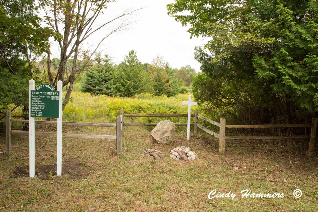
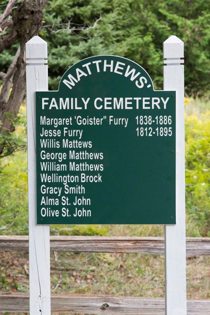
| Description | : | The cemetery is located S20 T42N R6E along the boundary of the Rock Golf Course that fills section 20 Drummond Township A transcription below lists all burials recorded for this tiny private Cemetery. The Matthews Family Cemetery was once located on the Matthews Homestead. There are no surviving markers or headstones except for one large boulder. A fence was erected when the local golf course was constructed, after living family members asked for help. Jesse Furry is my ancestor. The existance and location of the cemetery was confirmed by Jill Brumwell author of several books about Drummond Island.... Read More |
frequently asked questions (FAQ):
-
Where is Matthews Family Cemetery?
Matthews Family Cemetery is located at Drummond, Chippewa County ,Michigan ,USA.
-
Matthews Family Cemetery cemetery's updated grave count on graveviews.com?
0 memorials
-
Where are the coordinates of the Matthews Family Cemetery?
Latitude: 46.0212200
Longitude: -83.6860400
Nearby Cemetories:
1. Saint Florence Catholic Cemetery
Drummond, Chippewa County, USA
Coordinate: 46.0094150, -83.7380720
2. Drummond Cemetery
Drummond, Chippewa County, USA
Coordinate: 46.0071983, -83.7378006
3. Seaman Family Cemetery
Drummond, Chippewa County, USA
Coordinate: 46.0197790, -83.7458180
4. Finnish Cemetery
Drummond, Chippewa County, USA
Coordinate: 45.9721985, -83.6536026
5. Fort Drummond Burial Ground
Drummond, Chippewa County, USA
Coordinate: 45.9767820, -83.8688140
6. Riverside Cemetery
De Tour Village, Chippewa County, USA
Coordinate: 45.9833200, -83.9018800
7. Bob Hill Cemetery
De Tour Village, Chippewa County, USA
Coordinate: 45.9805984, -83.9103012
8. Sacred Heart Cemetery
De Tour Village, Chippewa County, USA
Coordinate: 46.0008011, -83.9413986
9. Maple Grove Cemetery
De Tour Village, Chippewa County, USA
Coordinate: 45.9864006, -83.9627991
10. Tenby Bay Cemetery
Jocelyn, Algoma District, Canada
Coordinate: 46.1267000, -83.9246090
11. Cockburn Island Cemetery
Cockburn Island, Manitoulin District, Canada
Coordinate: 45.9513880, -83.3282430
12. Mountain Maple Grove Cemetery
Jocelyn, Algoma District, Canada
Coordinate: 46.1906800, -83.9749640
13. Saint Boniface Catholic Cemetery
Hilton Beach, Algoma District, Canada
Coordinate: 46.2518340, -83.8799940
14. Lytle Cemetery
Goetzville, Chippewa County, USA
Coordinate: 46.0285988, -84.0761032
15. Saint John's Anglican Cemetery
Hilton Beach, Algoma District, Canada
Coordinate: 46.2537500, -83.8982600
16. Grace United Cemetery
Hilton Beach, Algoma District, Canada
Coordinate: 46.2524630, -83.9040880
17. Saint Stanislaus Catholic Cemetery
Goetzville, Chippewa County, USA
Coordinate: 46.0583420, -84.0967407
18. Forest Lawn Cemetery
Thessalon, Algoma District, Canada
Coordinate: 46.2966640, -83.5545540
19. Holy Trinity Anglican Cemetery
Jocelyn, Algoma District, Canada
Coordinate: 46.1893570, -84.0271500
20. Little Rapids Cemetery
Little Rapids, Algoma District, Canada
Coordinate: 46.2971500, -83.5546100
21. Trunk Road Cemetery
Bruce Mines, Algoma District, Canada
Coordinate: 46.3079480, -83.7614200
22. North Raber Cemetery
Raber, Chippewa County, USA
Coordinate: 46.1227989, -84.0927963
23. Cloudslee Cemetery
Cloudslee, Algoma District, Canada
Coordinate: 46.3229580, -83.7078990
24. Pine Grove Cemetery
Thessalon, Algoma District, Canada
Coordinate: 46.3111420, -83.5409620