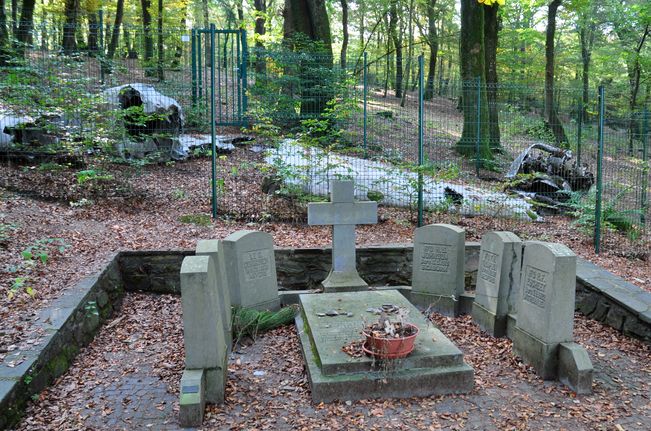
| Memorials | : | 0 |
| Location | : | Canton de Clervaux, Luxembourg |
| Coordinate | : | 50.0925000, 6.0208333 |
| Description | : | Maulusmuhle is in the north of Luxembourg near the village of Asselborn. From Maulusmuhle village follow the signs to the Monument Britannique. The monument is located in the hills and can, with care, be reached by car. GPS Co-ordinates: Longitude 06°01'15", Latitude 50°05'33" Historical Information: The burials at Maulusmuhle were left where an aircraft of 161 Squadron R.A.F. was shot down on 21 March 1945, when returning from a special mission in Germany. Three airmen are buried in the graves, together with three Belgian casualties, which are marked by locally made rather than Commission headstones. The remains of the aircraft,... Read More |
frequently asked questions (FAQ):
-
Where is Maulusmuhle Isolated Graves?
Maulusmuhle Isolated Graves is located at Canton de Clervaux ,Diekirch ,Luxembourg.
-
Maulusmuhle Isolated Graves cemetery's updated grave count on graveviews.com?
0 memorials
-
Where are the coordinates of the Maulusmuhle Isolated Graves?
Latitude: 50.0925000
Longitude: 6.0208333
Nearby Cemetories:
1. Heinerscheid Churchyard
Hupperdange, Canton de Clervaux, Luxembourg
Coordinate: 50.0942900, 6.0593500
2. Abbaye Saint Maurice
Clervaux, Canton de Clervaux, Luxembourg
Coordinate: 50.0549400, 6.0305100
3. Bas Bellain Churchyard
Basbellain, Canton de Clervaux, Luxembourg
Coordinate: 50.1451600, 5.9823300
4. Kriegsgräberstätte Daleiden
Daleiden, Landkreis Bitburg-Prüm, Germany
Coordinate: 50.0681520, 6.1870060
5. Bovigny Churchyard
Gouvy, Arrondissement de Bastogne, Belgium
Coordinate: 50.2249300, 5.9178300
6. St. Peter Friedhof
Scheitenkorb, Landkreis Bitburg-Prüm, Germany
Coordinate: 50.0069152, 6.2099562
7. Friedhof Merscheid les Putscheid
Hoscheid, Canton de Clervaux, Luxembourg
Coordinate: 49.9543997, 6.1077700
8. Sankt Jacobus Friedhof
Rodershausen, Landkreis Bitburg-Prüm, Germany
Coordinate: 49.9907782, 6.1947130
9. Houffalize Communal Cemetery
Houffalize, Arrondissement de Bastogne, Belgium
Coordinate: 50.1376100, 5.7884100
10. Commanster
Gouvy, Arrondissement de Bastogne, Belgium
Coordinate: 50.2485003, 6.0046066
11. Église Sainte-Catherine
Houffalize, Arrondissement de Bastogne, Belgium
Coordinate: 50.1333330, 5.7833330
12. Dahl Cemetery
Dahl, Canton de Wiltz, Luxembourg
Coordinate: 49.9353190, 5.9726590
13. Friedhof St. Bernhard
Berscheid, Landkreis Bitburg-Prüm, Germany
Coordinate: 49.9821441, 6.2318521
14. Bourscheid
Bourscheid, Canton de Diekirch, Luxembourg
Coordinate: 49.9101140, 6.0651400
15. Recogne German Military Cemetery
Bastogne, Arrondissement de Bastogne, Belgium
Coordinate: 50.0493900, 5.7407200
16. Waldfriedhof
Neuerburg, Landkreis Bitburg-Prüm, Germany
Coordinate: 50.0073078, 6.2817789
17. Salmchateau Cemetery
Vielsalm, Arrondissement de Bastogne, Belgium
Coordinate: 50.2662300, 5.9085100
18. Ehrenfriedhof
Neuerburg, Landkreis Bitburg-Prüm, Germany
Coordinate: 50.0134734, 6.2918681
19. Brandenbourg Catholic Church Cemetery
Brandenbourg, Canton de Vianden, Luxembourg
Coordinate: 49.9116813, 6.1363176
20. Friedhof Neuerburg
Neuerburg, Landkreis Bitburg-Prüm, Germany
Coordinate: 50.0050472, 6.3002857
21. Vielsalm Communal Cemetery
Vielsalm, Arrondissement de Bastogne, Belgium
Coordinate: 50.2835900, 5.9199300
22. Bastogne Communal Cemetery
Bastogne, Arrondissement de Bastogne, Belgium
Coordinate: 50.0088300, 5.7172700
23. Friedhof Bettel
Bettel, Canton de Vianden, Luxembourg
Coordinate: 49.9192925, 6.2235181
24. Friedhof Niedergeckler
Niedergeckler, Landkreis Bitburg-Prüm, Germany
Coordinate: 49.9702241, 6.3057402

