
| Memorials | : | 1 |
| Location | : | Westmeath, Renfrew County, Canada |
| Coordinate | : | 45.7178231, -77.0010204 |
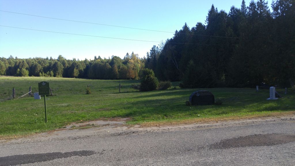
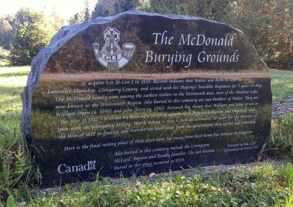
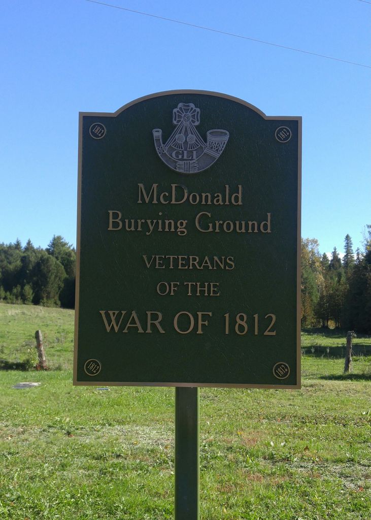
| Description | : | From Highway 17 take Sutherland Rd and cemetery is on the left about 0.8 km from Highway 17. Established between 1835 and 1869, the first burial occurred in 1869 and the last one in 1924. This small family cemetery, became abandoned and through the years, trees, shrubs, poison ivy took over to the point that no headstones were seen. ... Read More |
frequently asked questions (FAQ):
-
Where is McDonald Burying Ground?
McDonald Burying Ground is located at Sutherland Rd Westmeath, Renfrew County ,Ontario ,Canada.
-
McDonald Burying Ground cemetery's updated grave count on graveviews.com?
1 memorials
-
Where are the coordinates of the McDonald Burying Ground?
Latitude: 45.7178231
Longitude: -77.0010204
Nearby Cemetories:
1. Stafford United Church Cemetery
Cobden, Renfrew County, Canada
Coordinate: 45.7120380, -77.0029160
2. Saint Patricks Anglican Cemetery
Cobden, Renfrew County, Canada
Coordinate: 45.7103750, -77.0024870
3. Grace United Church Cemetery
Perretton, Renfrew County, Canada
Coordinate: 45.7556200, -76.9519100
4. Saint Stephen Anglican Cemetery
Micksburg, Renfrew County, Canada
Coordinate: 45.6759620, -77.0546720
5. Micksburg Presbyterian Cemetery
Micksburg, Renfrew County, Canada
Coordinate: 45.6705200, -77.0462600
6. Greenwood United Church Cemetery
Greenwood, Renfrew County, Canada
Coordinate: 45.7751000, -77.0136800
7. Micksburg United Cemetery
Micksburg, Renfrew County, Canada
Coordinate: 45.6615600, -77.0353000
8. Rankin Methodist Cemetery
Rankin, Renfrew County, Canada
Coordinate: 45.6909530, -77.1042160
9. Locksley United Cemetery
Locksley, Renfrew County, Canada
Coordinate: 45.7196000, -77.1286000
10. Grace Evangelical Cemetery
Rankin, Renfrew County, Canada
Coordinate: 45.6704010, -77.1212270
11. St. Augustine Anglican Cemetery
Beachburg, Renfrew County, Canada
Coordinate: 45.7306000, -76.8597300
12. St. Augustines Anglican
Westmeath, Renfrew County, Canada
Coordinate: 45.7306000, -76.8597000
13. Saint Pius V Cemetery
Osceola, Renfrew County, Canada
Coordinate: 45.6257000, -76.9445000
14. Beachburg Union Cemetery
Beachburg, Renfrew County, Canada
Coordinate: 45.7300987, -76.8577194
15. Grace Lutheran Cemetery-Locksley
Pembroke, Renfrew County, Canada
Coordinate: 45.7464660, -77.1411040
16. Pioneer Cemetery
Osceola, Renfrew County, Canada
Coordinate: 45.6231291, -76.9430902
17. Beachburg Mennonite Cemetery
Beachburg, Renfrew County, Canada
Coordinate: 45.6751052, -76.8551953
18. Beachburg Mennonite Cemetery
Cobden, Renfrew County, Canada
Coordinate: 45.6728430, -76.8527980
19. Pembroke Pentecostal Cemetery
Pembroke, Renfrew County, Canada
Coordinate: 45.8181360, -77.0767450
20. Westmeath Union Cemetery
Westmeath, Renfrew County, Canada
Coordinate: 45.8145470, -76.8879170
21. Grey Sisters RC Collumbkille
Pembroke, Renfrew County, Canada
Coordinate: 45.8272000, -77.0982700
22. St. Columbkille Cathedral
Pembroke, Renfrew County, Canada
Coordinate: 45.8239020, -77.1159950
23. St. Joseph's Roman Catholic Cemetery
Saint-Joseph, Outaouais Region, Canada
Coordinate: 45.8525000, -76.9905841
24. Holy Trinity Anglican Cemetery
Pembroke, Renfrew County, Canada
Coordinate: 45.8200684, -77.1275406