
| Memorials | : | 0 |
| Location | : | Sierra County, USA |
| Coordinate | : | 39.6545730, -120.9034680 |
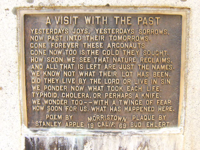
| Description | : | Morristown is the site of what was a California gold-rush era mining town. The cemetery is very small and in a very remote part of Sierra County within the Tahoe National Forest. There are only 5 stone markers with names, but numerous other places where obvious depressions in the earth and arranged stones indicate there are more people buried whose markers have long since deteriorated with time. |
frequently asked questions (FAQ):
-
Where is Morristown Cemetery?
Morristown Cemetery is located at Sierra County ,California ,USA.
-
Morristown Cemetery cemetery's updated grave count on graveviews.com?
0 memorials
-
Where are the coordinates of the Morristown Cemetery?
Latitude: 39.6545730
Longitude: -120.9034680

Nearby Cemetories:
1. L H Merritt Gravesite
Queen City, Sierra County, USA
Coordinate: 39.6624900, -120.9194500
2. Port Wine Cemetery
Sierra County, USA
Coordinate: 39.6610300, -120.9525400
3. Eureka Cemetery
Sierra County, USA
Coordinate: 39.6119003, -120.8889008
4. Saint Louis Cemetery
Sierra County, USA
Coordinate: 39.6967010, -120.9302979
5. Secret Diggings Graves
La Porte, Plumas County, USA
Coordinate: 39.6688280, -120.9812530
6. Howland Flat Cemetery
Howland Flat, Sierra County, USA
Coordinate: 39.7152500, -120.8821900
7. Pine Grove Cemetery
Sierra County, USA
Coordinate: 39.7174988, -120.8983002
8. La Porte Cemetery
La Porte, Plumas County, USA
Coordinate: 39.6804300, -120.9835350
9. Bald Mountain Cemetery
Downieville, Sierra County, USA
Coordinate: 39.5752800, -120.8969400
10. Gibsonville Cemetery
Gibsonville, Sierra County, USA
Coordinate: 39.7448700, -120.9097100
11. Scales Cemetery
Scales, Sierra County, USA
Coordinate: 39.5978500, -120.9969400
12. Whiskey Diggings Cemetery
Sierra County, USA
Coordinate: 39.7504200, -120.8868700
13. Downieville Cemetery
Downieville, Sierra County, USA
Coordinate: 39.5676700, -120.8252390
14. Goodyears Bar Cemetery
Goodyears Bar, Sierra County, USA
Coordinate: 39.5403470, -120.8836760
15. Brandy City Cemetery
Sierra County, USA
Coordinate: 39.5379300, -121.0242700
16. Forest Old Pioneer Cemetery
Forest, Sierra County, USA
Coordinate: 39.4939410, -120.8515940
17. Forest City Cemetery
Forest, Sierra County, USA
Coordinate: 39.4883100, -120.8553100
18. Strawberry Valley Cemetery
Strawberry Valley, Yuba County, USA
Coordinate: 39.5614014, -121.1138992
19. Andrew J Brineger Gravesite
Quincy, Plumas County, USA
Coordinate: 39.8380230, -120.8486450
20. Alleghany Cemetery
Alleghany, Sierra County, USA
Coordinate: 39.4696900, -120.8429100
21. Johnsville Cemetery
Johnsville, Plumas County, USA
Coordinate: 39.7627983, -120.6913986
22. Sleighville House Cemetery
Alleghany, Sierra County, USA
Coordinate: 39.4711100, -121.0091700
23. Sierra City Cemetery
Sierra City, Sierra County, USA
Coordinate: 39.5663900, -120.6408300
24. Youngs Hill Cemetery
Camptonville, Yuba County, USA
Coordinate: 39.4765200, -121.0776600