
| Memorials | : | 0 |
| Location | : | Forest, Sierra County, USA |
| Coordinate | : | 39.4939410, -120.8515940 |
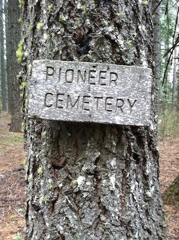
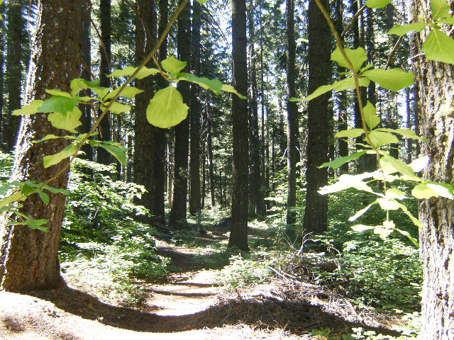
| Description | : | The old Pioneer Cemetery for the town of Forest, CA is on federally owned land within the Tahoe National Forest. It is just outside of town in a protected area adjacent to recent logging activity. It is difficult to locate, and difficult to explain how to find it. I'd advise having a local resident give directions and/or guide you to it's location. From what I've been told by a local whom I work with, there are many more graves in this cemetery than there are markers for. But as is common with most rural old pioneer cemeteries, many of the... Read More |
frequently asked questions (FAQ):
-
Where is Forest Old Pioneer Cemetery?
Forest Old Pioneer Cemetery is located at Forest, Sierra County ,California ,USA.
-
Forest Old Pioneer Cemetery cemetery's updated grave count on graveviews.com?
0 memorials
-
Where are the coordinates of the Forest Old Pioneer Cemetery?
Latitude: 39.4939410
Longitude: -120.8515940
Nearby Cemetories:
1. Forest City Cemetery
Forest, Sierra County, USA
Coordinate: 39.4883100, -120.8553100
2. Alleghany Cemetery
Alleghany, Sierra County, USA
Coordinate: 39.4696900, -120.8429100
3. Goodyears Bar Cemetery
Goodyears Bar, Sierra County, USA
Coordinate: 39.5403470, -120.8836760
4. Moores Flat Cemetery
Moores Flat, Nevada County, USA
Coordinate: 39.4275170, -120.8556670
5. Downieville Cemetery
Downieville, Sierra County, USA
Coordinate: 39.5676700, -120.8252390
6. Bald Mountain Cemetery
Downieville, Sierra County, USA
Coordinate: 39.5752800, -120.8969400
7. Graniteville Cemetery
Graniteville, Nevada County, USA
Coordinate: 39.4395860, -120.7462590
8. Eureka Cemetery
Sierra County, USA
Coordinate: 39.6119003, -120.8889008
9. Sleighville House Cemetery
Alleghany, Sierra County, USA
Coordinate: 39.4711100, -121.0091700
10. Pike City Cemetery
Pike, Sierra County, USA
Coordinate: 39.4358400, -121.0002400
11. North Bloomfield Cemetery
North Bloomfield, Nevada County, USA
Coordinate: 39.3678150, -120.9038890
12. Relief Hill Cemetery
North Bloomfield, Nevada County, USA
Coordinate: 39.3552140, -120.8610870
13. Brandy City Cemetery
Sierra County, USA
Coordinate: 39.5379300, -121.0242700
14. Washington Cemetery
Washington, Nevada County, USA
Coordinate: 39.3573220, -120.8010220
15. Scales Cemetery
Scales, Sierra County, USA
Coordinate: 39.5978500, -120.9969400
16. Camptonville Cemetery
Camptonville, Yuba County, USA
Coordinate: 39.4508018, -121.0472031
17. Morristown Cemetery
Sierra County, USA
Coordinate: 39.6545730, -120.9034680
18. Youngs Hill Cemetery
Camptonville, Yuba County, USA
Coordinate: 39.4765200, -121.0776600
19. L H Merritt Gravesite
Queen City, Sierra County, USA
Coordinate: 39.6624900, -120.9194500
20. Sierra City Cemetery
Sierra City, Sierra County, USA
Coordinate: 39.5663900, -120.6408300
21. Omega Cemetery
Omega, Nevada County, USA
Coordinate: 39.3310100, -120.7498500
22. Port Wine Cemetery
Sierra County, USA
Coordinate: 39.6610300, -120.9525400
23. Fall Creek Cemetery
Camp Spaulding, Nevada County, USA
Coordinate: 39.3806200, -120.6619410
24. Crystal Hermitage Moksha Mandir
Nevada City, Nevada County, USA
Coordinate: 39.3850646, -121.0488795