
| Memorials | : | 0 |
| Location | : | Taylor, Marion County, USA |
| Coordinate | : | 39.9165910, -91.5353310 |
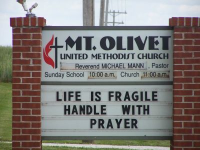
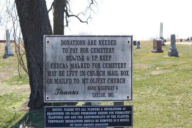
| Description | : | This cemetery is often confused with Mount Olivet Cemetery in Hannibal Missouri, also in Marion County. Death certificates and other documents indicating this cemetery will usually say "Taylor" or "Marion County", while those for the larger Mount Olivet Cemetery will almost always indicate "Hannibal". Few if any residents from Hannibal have been interred in the much smaller Mount Olivet Cemetery (United Methodist Church). Driving directions: From US 61 near Taylor Missouri, take Mo Hwy 6 west for 1/2 mile. Mount Olivet Cemetery (United Methodist Church) is on the left side (south) across the highway from the church. The Cemetery is located... Read More |
frequently asked questions (FAQ):
-
Where is Mount Olivet Cemetery?
Mount Olivet Cemetery is located at Taylor, Marion County ,Missouri ,USA.
-
Mount Olivet Cemetery cemetery's updated grave count on graveviews.com?
0 memorials
-
Where are the coordinates of the Mount Olivet Cemetery?
Latitude: 39.9165910
Longitude: -91.5353310
Nearby Cemetories:
1. Apostolic Cemetery
Taylor, Marion County, USA
Coordinate: 39.9446100, -91.5295400
2. Cave Cemetery
Hester, Marion County, USA
Coordinate: 39.9220700, -91.5803400
3. Sudduth Cemetery
Marion County, USA
Coordinate: 39.9211000, -91.5918400
4. Bethel Baptist Church Cemetery
Palmyra, Marion County, USA
Coordinate: 39.8672090, -91.5696500
5. Maywood Cemetery
Maywood, Lewis County, USA
Coordinate: 39.9597015, -91.5883026
6. Tate Cemetery
Marion County, USA
Coordinate: 39.9001250, -91.6168886
7. Sunrise Cemetery
Marion County, USA
Coordinate: 39.9207993, -91.6232986
8. Kempf Family Cemetery
Marion County, USA
Coordinate: 39.8474006, -91.5273934
9. Hebron Cemetery
Marion County, USA
Coordinate: 39.9399986, -91.6219025
10. Hester Cemetery
Hester, Marion County, USA
Coordinate: 39.9108778, -91.6268255
11. Liberty Cemetery
La Grange, Lewis County, USA
Coordinate: 39.9975000, -91.5683330
12. McPike Cemetery
Marion County, USA
Coordinate: 39.8833008, -91.6380997
13. Carson Cemetery
Marion County, USA
Coordinate: 39.8526200, -91.6157700
14. Hitch-Smoot Family Cemetery
Marion County, USA
Coordinate: 39.8574613, -91.6264251
15. McPike Family Cemetery
Palmyra, Marion County, USA
Coordinate: 39.8291020, -91.5862060
16. Woodland Cemetery
Quincy, Adams County, USA
Coordinate: 39.9188995, -91.4085999
17. Pleasant Grove Cemetery
Marion County, USA
Coordinate: 39.8368988, -91.6113968
18. Banks Cemetery
Marion County, USA
Coordinate: 39.8800011, -91.6552963
19. Massie Cemetery
Palmyra, Marion County, USA
Coordinate: 39.8176000, -91.5167600
20. Jefferson Square Cemetery
Quincy, Adams County, USA
Coordinate: 39.9351340, -91.4070400
21. Humphrey Cemetery
Emerson, Marion County, USA
Coordinate: 39.9466610, -91.6613820
22. Saint Joseph Cemetery
Palmyra, Marion County, USA
Coordinate: 39.8113600, -91.5228100
23. Dover Cemetery
La Grange, Lewis County, USA
Coordinate: 40.0109700, -91.5979100
24. Cobb Cemetery
Marion County, USA
Coordinate: 39.8161011, -91.4888992