
| Memorials | : | 2 |
| Location | : | Naper, Boyd County, USA |
| Coordinate | : | 42.9701200, -99.0183400 |
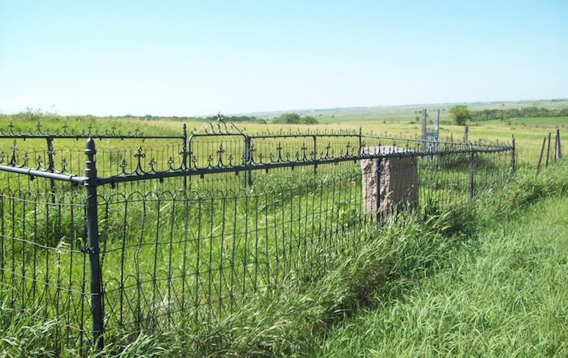
| Description | : | Highway 12 west towards Naper from Butte, turn north (right) onto Road 474 go 2.2 miles. Cemetery on west (left) side of the road. Consists of some grave markers inside of iron fence, with additional markers outside. Cemetery was at one time referred to as the Free Methodist Cemetery and was associated with a church at the same location. Currently the local residents and one government document refer to this cemetery as "The Cemetery." |
frequently asked questions (FAQ):
-
Where is Mount Zion Cemetery?
Mount Zion Cemetery is located at Naper, Boyd County ,Nebraska ,USA.
-
Mount Zion Cemetery cemetery's updated grave count on graveviews.com?
2 memorials
-
Where are the coordinates of the Mount Zion Cemetery?
Latitude: 42.9701200
Longitude: -99.0183400


Nearby Cemetories:
1. Knoll Crest Cemetery
Naper, Boyd County, USA
Coordinate: 42.9589005, -99.0875015
2. Sacred Heart Cemetery
Naper, Boyd County, USA
Coordinate: 42.9586400, -99.0905900
3. Pleasant Valley Cemetery
Bonesteel, Gregory County, USA
Coordinate: 43.0327988, -98.9796982
4. Lutheran Cemetery
Naper, Boyd County, USA
Coordinate: 42.9585980, -99.1268810
5. German Cemetery
Naper, Boyd County, USA
Coordinate: 42.9696999, -99.1350021
6. Southside Cemetery
Holt County, USA
Coordinate: 42.8842139, -98.9931842
7. Saint Francis Xavier Cemetery
Saint Charles, Gregory County, USA
Coordinate: 43.0094337, -99.1375152
8. Baptist Cemetery
Naper, Boyd County, USA
Coordinate: 42.9730988, -99.1564026
9. Adams Cemetery
Holt County, USA
Coordinate: 42.8706000, -98.9694500
10. Trinity Lutheran Cemetery
Fairfax, Gregory County, USA
Coordinate: 43.0102997, -98.8842010
11. Highland Cemetery
Fairfax, Gregory County, USA
Coordinate: 43.0236015, -98.8930969
12. Milks Camp Episcopal Cemetery
Saint Charles, Gregory County, USA
Coordinate: 43.0378199, -99.1552354
13. Ponca Creek UCC Cemetery
Gregory County, USA
Coordinate: 43.0451800, -99.1491700
14. Saint Marys Cemetery
Bonesteel, Gregory County, USA
Coordinate: 43.0816994, -98.9413986
15. Saints Peter and Paul Cemetery
Butte, Boyd County, USA
Coordinate: 42.9221992, -98.8593979
16. Butte Cemetery
Butte, Boyd County, USA
Coordinate: 42.9235992, -98.8585968
17. Rosebud Cemetery
Bonesteel, Gregory County, USA
Coordinate: 43.0835991, -98.9405975
18. Saint Anthonys Cemetery
Fairfax, Gregory County, USA
Coordinate: 43.0532990, -98.8835983
19. Anoka Lutheran Cemetery
Anoka, Boyd County, USA
Coordinate: 42.9522018, -98.8349991
20. Immanuel Lutheran Cemetery
Butte, Boyd County, USA
Coordinate: 42.9006004, -98.8497009
21. Oak Dale Cemetery
Naper, Boyd County, USA
Coordinate: 42.8847008, -99.1939011
22. Old Settlers Cemetery
Anoka, Boyd County, USA
Coordinate: 42.9730988, -98.8005981
23. Bethlehem Cemetery
Gregory County, USA
Coordinate: 43.0102997, -98.8041992
24. West Hill Cemetery
Fairfax, Gregory County, USA
Coordinate: 43.0132440, -98.7839660