
| Memorials | : | 9 |
| Location | : | Henry County, USA |
| Coordinate | : | 36.3710830, -88.0424900 |
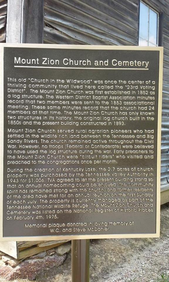
| Description | : | From the intersection of TN-69 A & Atchison Ln., in Springville, travel 4.2 mi., entering Big Sandy in Benton Co.; turning north (left) onto Main St., going 100 yards; turning east (slightly right) onto Front St., going 0.1 mi.; turning north (left) onto 2nd St, for 0.1 mi.; turning east (right) onto Lick Creek Rd., going 0.3 mi.; turning (left) to continue on Lick Creek Rd. for 10.1 mi., re-entering Henry Co.; turning northwest (left) at a fork, going 1.2 mi., turning west (left) into the parking area of the old 'abandoned' Mt Zion Church & the cemetery further... Read More |
frequently asked questions (FAQ):
-
Where is Mount Zion Cemetery?
Mount Zion Cemetery is located at Bennetts Creek Road Henry County ,Tennessee , 38221USA.
-
Mount Zion Cemetery cemetery's updated grave count on graveviews.com?
9 memorials
-
Where are the coordinates of the Mount Zion Cemetery?
Latitude: 36.3710830
Longitude: -88.0424900


Nearby Cemetories:
1. Fairview Cemetery
Henry County, USA
Coordinate: 36.3841920, -88.0505820
2. Baker Cheatham Cemetery
Henry County, USA
Coordinate: 36.3889800, -88.0434870
3. Culpepper Cemetery
Henry County, USA
Coordinate: 36.3717003, -88.0714035
4. Evans Cemetery
Lick Creek, Benton County, USA
Coordinate: 36.3545670, -88.0823190
5. Liberty Cemetery
Lick Creek, Benton County, USA
Coordinate: 36.3436012, -88.0727997
6. Oak Hill Church Cemetery
Benton County, USA
Coordinate: 36.3325890, -88.0643370
7. Ralls Cemetery
Lick Creek, Benton County, USA
Coordinate: 36.3398060, -88.0004690
8. Dortch Cemetery
Big Sandy, Benton County, USA
Coordinate: 36.3303010, -88.0764280
9. Stockdale Cemetery
Big Sandy, Benton County, USA
Coordinate: 36.3243550, -88.0177690
10. Leegan Cemetery
Benton County, USA
Coordinate: 36.3292590, -88.0784920
11. Bomar Hill Cemetery
Stewart County, USA
Coordinate: 36.3633003, -87.9785995
12. Lick Creek Church Cemetery
Big Sandy, Benton County, USA
Coordinate: 36.3214910, -88.0213010
13. Brannon Cemetery
Henry County, USA
Coordinate: 36.3986015, -88.0994034
14. Daniel Cemetery
Benton County, USA
Coordinate: 36.3235970, -88.0031586
15. Bond-Limekiln Cemetery
Henry County, USA
Coordinate: 36.3367004, -88.0991974
16. Herndon Cemetery
Big Sandy, Benton County, USA
Coordinate: 36.3234460, -88.0032510
17. Medlock Cemetery
Big Sandy, Benton County, USA
Coordinate: 36.3210000, -88.0799320
18. Precinct Cemetery
Big Sandy, Benton County, USA
Coordinate: 36.3009500, -88.0284500
19. Walker Cemetery #2
Springville, Henry County, USA
Coordinate: 36.3643510, -88.1313370
20. Chick Cemetery
Henry County, USA
Coordinate: 36.3586006, -88.1324997
21. Hopkins Cemetery
Oak Grove, Henry County, USA
Coordinate: 36.3759680, -88.1336650
22. Gray Cemetery
Stewart County, USA
Coordinate: 36.4488983, -88.0457993
23. Grafried Cemetery
Houston County, USA
Coordinate: 36.3311005, -87.9591980
24. John Bush Cemetery
McKinnon, Houston County, USA
Coordinate: 36.3415600, -87.9513400