
| Memorials | : | 0 |
| Location | : | Neshoba County, USA |
| Coordinate | : | 32.5929070, -89.1716050 |
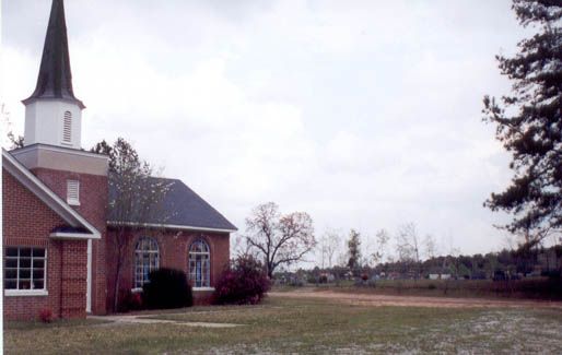
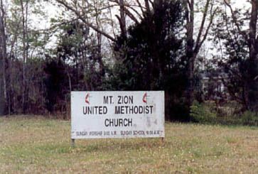
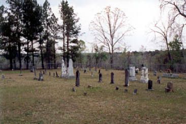
| Description | : | This is the "White" Mount Zion United Methodist Church Cemetery in Neshoba County, MS. Directions: From the Hwy 15 & Hwy 492 intersection in Union, MS.: Proceed west on Hwy 492 for 2.4 miles. Turn right at the old two story abandoned store on the right side of Hwy 492 onto Ideal Store Road for 4.7 miles. The church will be on the right. It sits very far back from the road. There will be a sign near the road and the driveway leads up to the church. The cemetery sits off to the right as you... Read More |
frequently asked questions (FAQ):
-
Where is Mount Zion United Methodist Church Cemetery?
Mount Zion United Methodist Church Cemetery is located at 13001 County Road 210 Neshoba County ,Mississippi ,USA.
-
Mount Zion United Methodist Church Cemetery cemetery's updated grave count on graveviews.com?
0 memorials
-
Where are the coordinates of the Mount Zion United Methodist Church Cemetery?
Latitude: 32.5929070
Longitude: -89.1716050
Nearby Cemetories:
1. New Ireland Baptist Church Cemetery
New Ireland, Newton County, USA
Coordinate: 32.5635490, -89.1785278
2. Union Pentecostal Church Cemetery
Union, Neshoba County, USA
Coordinate: 32.6017302, -89.1330688
3. Abney Cemetery
Union, Newton County, USA
Coordinate: 32.5611000, -89.1889038
4. Neshoba Cemetery
Neshoba County, USA
Coordinate: 32.6236000, -89.1391983
5. Union Church of God
Neshoba, Neshoba County, USA
Coordinate: 32.5950470, -89.1227390
6. Springhill M.B. Church Cemetery
Union, Newton County, USA
Coordinate: 32.5566800, -89.1464110
7. Greater Rose Hill M.B. Church Cemetery
Union, Newton County, USA
Coordinate: 32.5683316, -89.1265826
8. Beech Springs Memorial Cemetery
Neshoba County, USA
Coordinate: 32.6027985, -89.2307968
9. Beech Springs Cemetery
Neshoba County, USA
Coordinate: 32.6031570, -89.2317300
10. Victory Fellowship Church
Neshoba, Neshoba County, USA
Coordinate: 32.6395770, -89.1393970
11. Memorial Park
Union, Newton County, USA
Coordinate: 32.5679512, -89.1113968
12. Evans Tabernacle Church of God Cemetery
Newton County, USA
Coordinate: 32.5464325, -89.2201385
13. Pinckney Baptist Church Cemetery
Union, Newton County, USA
Coordinate: 32.5317612, -89.1583862
14. Hudson Chapel Church of God Cemetery
Union, Newton County, USA
Coordinate: 32.5343310, -89.2098860
15. Griffins Rest Cemetery
Philadelphia, Neshoba County, USA
Coordinate: 32.6596370, -89.1420470
16. Linwood Cemetery
Philadelphia, Neshoba County, USA
Coordinate: 32.6626500, -89.1506700
17. Pine Grove Church Of God Cemetery
Dixon, Neshoba County, USA
Coordinate: 32.6530609, -89.2202835
18. Erin Cumberland Presbyterian Church Cemetery
Union, Newton County, USA
Coordinate: 32.5200615, -89.2011490
19. Golden Grove Cemetery
Neshoba, Neshoba County, USA
Coordinate: 32.6307983, -89.0905991
20. Dixon Cemetery
Dixon, Neshoba County, USA
Coordinate: 32.6610985, -89.2205963
21. Mount Enon MB Church Cemetery
Philadelphia, Neshoba County, USA
Coordinate: 32.6692970, -89.2024590
22. County Line Cemetery
Neshoba County, USA
Coordinate: 32.5835991, -89.0742035
23. Oak Ridge Cemetery
Neshoba County, USA
Coordinate: 32.6798470, -89.1727480
24. Rock Branch Baptist Church Cemetery
Union, Newton County, USA
Coordinate: 32.5445404, -89.0846786