
| Memorials | : | 49 |
| Location | : | Bostic, Rutherford County, USA |
| Coordinate | : | 35.4227630, -81.8080460 |
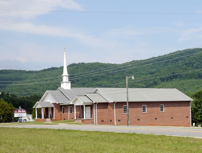
| Description | : | Located about 8 miles north of Forest City. This is not the Mountain View Baptist Church Cemetery located in Rutherfordton. |
frequently asked questions (FAQ):
-
Where is Mountain View Baptist Church Cemetery?
Mountain View Baptist Church Cemetery is located at 3590 Bostic Sunshine Hwy Bostic, Rutherford County ,North Carolina , 28018USA.
-
Mountain View Baptist Church Cemetery cemetery's updated grave count on graveviews.com?
49 memorials
-
Where are the coordinates of the Mountain View Baptist Church Cemetery?
Latitude: 35.4227630
Longitude: -81.8080460
Nearby Cemetories:
1. Hollifield Family Cemetery
Bostic, Rutherford County, USA
Coordinate: 35.4203956, -81.8117291
2. Sunshine United Methodist Church Cemetery
Bostic, Rutherford County, USA
Coordinate: 35.4286930, -81.8132680
3. Salem United Methodist Church Cemetery
Washburn, Rutherford County, USA
Coordinate: 35.4000015, -81.7985992
4. Cansler Cemetery
Sunshine, Rutherford County, USA
Coordinate: 35.4082600, -81.8350400
5. Cedar Grove United Methodist Church Cemetery
Rutherford County, USA
Coordinate: 35.4506110, -81.8097540
6. Mount Lebanon Cemetery
Rutherford County, USA
Coordinate: 35.4319000, -81.8414001
7. Cherry Mountain Freewill Baptist Cemetery
Washburn, Rutherford County, USA
Coordinate: 35.3929060, -81.7902790
8. Mount Harmony Baptist Church Cemetery
Bostic, Rutherford County, USA
Coordinate: 35.4588380, -81.7996940
9. Wilson Baptist Cemetery
Forest City, Rutherford County, USA
Coordinate: 35.4257164, -81.8531723
10. Ross Hill Baptist Church Cemetery
Bostic, Rutherford County, USA
Coordinate: 35.4575280, -81.7922220
11. Sweezy-Murray Family Cemetery
Rutherford County, USA
Coordinate: 35.4432090, -81.7671363
12. Duggar Freeman Cemetery
Rutherford County, USA
Coordinate: 35.4247780, -81.8585810
13. Robertson Creek Freewill Baptist Cemetery
Bostic, Rutherford County, USA
Coordinate: 35.3937840, -81.8465540
14. New Vernon Baptist Cemetery
Bostic, Rutherford County, USA
Coordinate: 35.3958320, -81.8497430
15. Green-Davis-Melton Cemetery
Rutherford County, USA
Coordinate: 35.3782930, -81.7928500
16. Walls Baptist Church Cemetery
Bostic, Rutherford County, USA
Coordinate: 35.3843141, -81.7757392
17. Wells Family Cemetery
Bostic, Rutherford County, USA
Coordinate: 35.3832400, -81.7757300
18. Sandy Level Baptist Cemetery
Bostic, Rutherford County, USA
Coordinate: 35.4591400, -81.8520440
19. Cooper Springs Congregational Holiness Church Ceme
Rutherford County, USA
Coordinate: 35.4755700, -81.7844540
20. Corinth Baptist Church Cemetery
Ellenboro, Rutherford County, USA
Coordinate: 35.3563900, -81.7971670
21. Brittain Cemetery
Rutherfordton, Rutherford County, USA
Coordinate: 35.4530983, -81.8861008
22. Mount Olivet Baptist Cemetery
Ellenboro, Rutherford County, USA
Coordinate: 35.4038530, -81.7240990
23. Smith Grove Baptist Cemetery
Forest City, Rutherford County, USA
Coordinate: 35.3740660, -81.8730180
24. White Oak Springs Baptist Cemetery
Ellenboro, Rutherford County, USA
Coordinate: 35.4086113, -81.7208328