
| Memorials | : | 0 |
| Location | : | Wedding, Mitte, Germany |
| Coordinate | : | 52.5452260, 13.3402350 |
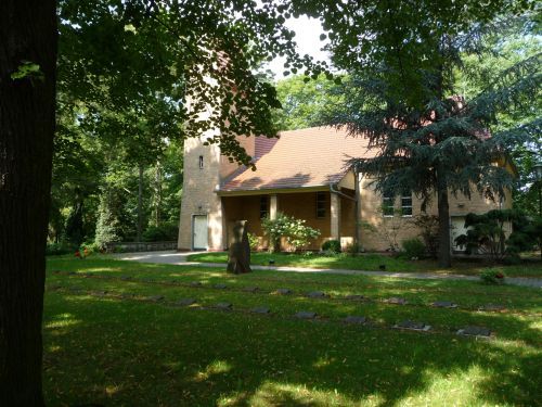
| Description | : | The three cemeteries along this block of the Seestrasse are Sankt Paul-Friedhof Nazareth-Kirchhof I Sankt Johannis-Friedhof II These three Lutheran Congregations share one chapel. The cemeteries were consecrated between 1866 and 1880, they are now collectively referred to as "Friedhof Seestrasse". Address: Seestrasse 125 13353 Berlin Tel.: 001 49 30 - 452 60 83 This first cemetery of the Lutheran Nazareth Congregation was established in 1870. It has the size of about 26,124 square meters or about 6.5 acres. This location is mainly used for regular (coffin) burials. There is another cemetery about 1 mile north on the same street, which is called Urnenfriedhof Seestrasse... Read More |
frequently asked questions (FAQ):
-
Where is Nazareth-Kirchhof I?
Nazareth-Kirchhof I is located at Seestrasse 125 Wedding, Mitte ,Berlin , 13353Germany.
-
Nazareth-Kirchhof I cemetery's updated grave count on graveviews.com?
0 memorials
-
Where are the coordinates of the Nazareth-Kirchhof I?
Latitude: 52.5452260
Longitude: 13.3402350
Nearby Cemetories:
1. St. Paul-Friedhof
Wedding, Mitte, Germany
Coordinate: 52.5452260, 13.3402350
2. Sankt Johannis-Friedhof II
Wedding, Mitte, Germany
Coordinate: 52.5436720, 13.3364380
3. Robert Koch Institut
Moabit, Mitte, Germany
Coordinate: 52.5391670, 13.3472220
4. Evangelischer Sankt Johannis und Heiland-Friedhof
Wedding, Mitte, Germany
Coordinate: 52.5449450, 13.3249980
5. St. Philippus-Apostel-Friedhof
Wedding, Mitte, Germany
Coordinate: 52.5522850, 13.3522510
6. Urnenfriedhof Seestrasse
Wedding, Mitte, Germany
Coordinate: 52.5527940, 13.3551260
7. Friedhof Turiner Strasse
Wedding, Mitte, Germany
Coordinate: 52.5490870, 13.3589780
8. Domfriedhof II
Wedding, Mitte, Germany
Coordinate: 52.5580700, 13.3399020
9. Urnenfriedhof Gerichtstrasse
Wedding, Mitte, Germany
Coordinate: 52.5461780, 13.3640310
10. Dorotheenstädtischer Friedhof III
Reinickendorf, Reinickendorf, Germany
Coordinate: 52.5628700, 13.3322535
11. Golgatha-Gnaden- und Johannes-Evangelist-Friedhof
Reinickendorf, Reinickendorf, Germany
Coordinate: 52.5625210, 13.3504060
12. Friedhof der Dankesgemeinde
Reinickendorf, Reinickendorf, Germany
Coordinate: 52.5652237, 13.3336687
13. Sankt Johannis-Friedhof I
Moabit, Mitte, Germany
Coordinate: 52.5253600, 13.3498050
14. Friedhof Wilnsnacker Straße
Mitte, Germany
Coordinate: 52.5250190, 13.3506060
15. Nazareth Kirchhof II
Reinickendorf, Reinickendorf, Germany
Coordinate: 52.5662155, 13.3354387
16. Beamtenfriedhof Berlin-Moabit
Moabit, Mitte, Germany
Coordinate: 52.5281527, 13.3653357
17. Invalidenfriedhof
Berlin-Mitte, Mitte, Germany
Coordinate: 52.5319440, 13.3711110
18. Domfriedhof I
Berlin-Mitte, Mitte, Germany
Coordinate: 52.5380200, 13.3772390
19. Dorotheenstädtischer Friedhof II
Mitte, Germany
Coordinate: 52.5401230, 13.3782990
20. Französischer Friedhof II
Berlin-Mitte, Mitte, Germany
Coordinate: 52.5382700, 13.3777100
21. St. Hedwig-Friedhof III
Reinickendorf, Reinickendorf, Germany
Coordinate: 52.5686302, 13.3318720
22. Alter Domfriedhof St. Hedwig
Berlin-Mitte, Mitte, Germany
Coordinate: 52.5384500, 13.3782700
23. Sankt Sebastian-Friedhof
Reinickendorf, Reinickendorf, Germany
Coordinate: 52.5704346, 13.3364258
24. Friedhof Reinickendorf II
Reinickendorf, Reinickendorf, Germany
Coordinate: 52.5716553, 13.3404284