
| Memorials | : | 0 |
| Location | : | Noble Lake, Jefferson County, USA |
| Coordinate | : | 34.1696660, -91.8479940 |
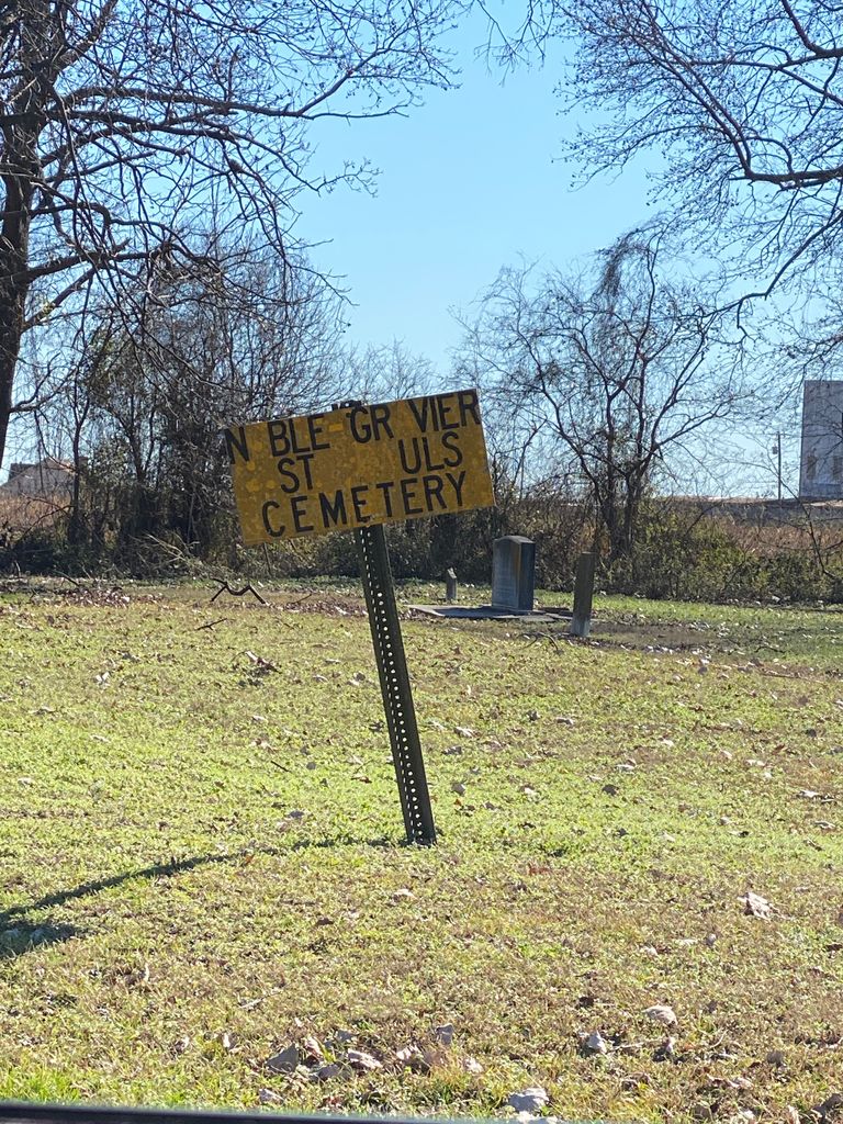
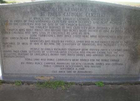
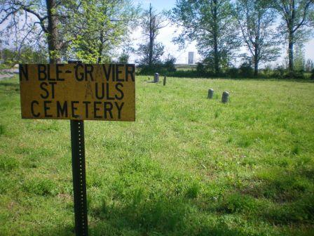
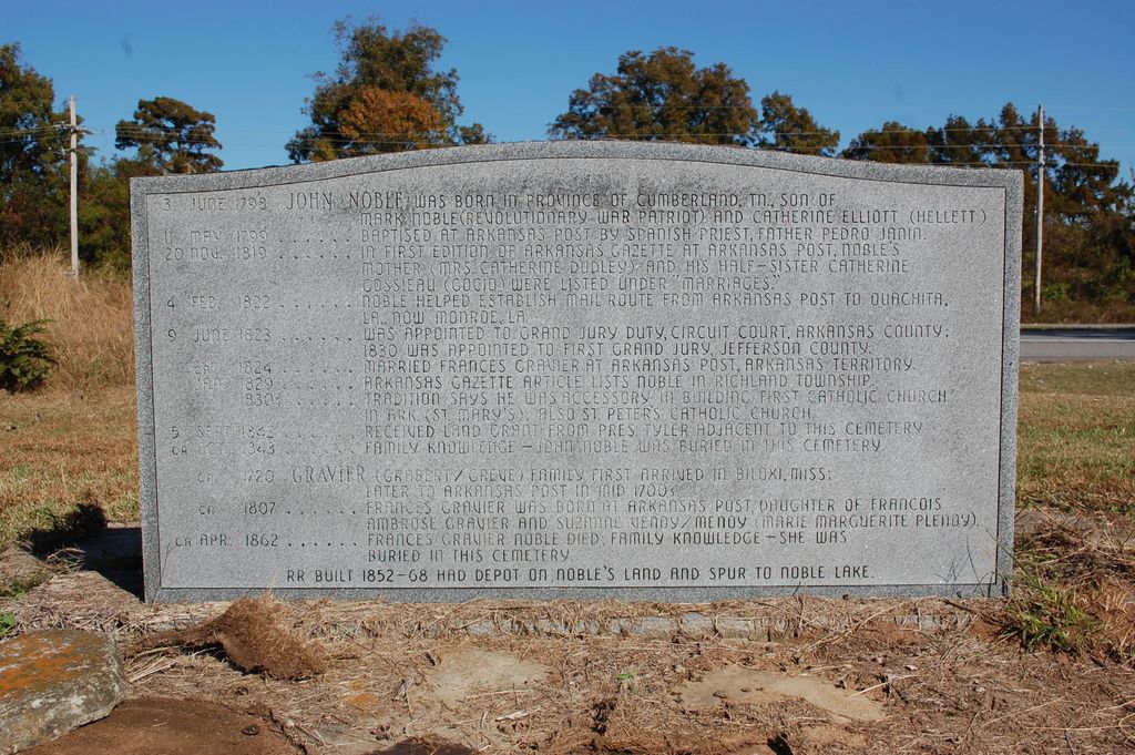
| Description | : | St. Paul's, one of the Earliest Catholic Churches in Jefferson County, once stood in front of this unmarked cemetery which occupies 6/10 acre. Highway 65 now runs between the cemetery and the site of the church building. The earliest burials in this cemetery were probably 1830 - 1840. The church was built about 1851 before two acres were deeded in 1852 by Emma Kelly (Emily Callius), and was still in existence as late as 1878. Some tombstones that once stood here have disappeared and some graves were likely never marked. The Territory of Arkansas achieved statehood in 1836. People of... Read More |
frequently asked questions (FAQ):
-
Where is Noble-Gravier Family Cemetery?
Noble-Gravier Family Cemetery is located at Noble Lake, Jefferson County ,Arkansas ,USA.
-
Noble-Gravier Family Cemetery cemetery's updated grave count on graveviews.com?
0 memorials
-
Where are the coordinates of the Noble-Gravier Family Cemetery?
Latitude: 34.1696660
Longitude: -91.8479940

Nearby Cemetories:
1. Pilgrim Rest Cemetery
Jefferson County, USA
Coordinate: 34.1653300, -91.8521400
2. Cottondale Cemetery
Jefferson County, USA
Coordinate: 34.1878014, -91.8597031
3. Hunters Cemetery
Jefferson County, USA
Coordinate: 34.1506004, -91.8324966
4. Patterson Cemetery
Jefferson County, USA
Coordinate: 34.1800003, -91.8775024
5. Mulberry Grove Cemetery
Jefferson County, USA
Coordinate: 34.1977997, -91.8364029
6. Saint Ruth Cemetery
Jefferson County, USA
Coordinate: 34.2092018, -91.8447037
7. Cherry Hill Cemetery
Jefferson County, USA
Coordinate: 34.1577988, -91.7975006
8. Atkins Cemetery
Jefferson County, USA
Coordinate: 34.2078018, -91.8792038
9. Smith Cemetery
Jefferson County, USA
Coordinate: 34.1397018, -91.8927994
10. Blackman Cemetery
Jefferson County, USA
Coordinate: 34.1528015, -91.7869034
11. Belmont Cemetery
Moscow, Jefferson County, USA
Coordinate: 34.1237760, -91.8137470
12. Stewart Chapel Cemetery
Jefferson County, USA
Coordinate: 34.1795120, -91.9126810
13. Macedonia Cemetery
Richland Township, Jefferson County, USA
Coordinate: 34.1273300, -91.8061100
14. Belmont Missionary Baptist Church Cemetery
Moscow, Jefferson County, USA
Coordinate: 34.1228583, -91.8122529
15. Shell Chapel Cumberland Presbyterian Church Cemete
Hooker, Jefferson County, USA
Coordinate: 34.1220620, -91.8838500
16. Madding
Madding, Jefferson County, USA
Coordinate: 34.2255105, -91.8374802
17. Jefferson Cemetery
Jefferson County, USA
Coordinate: 34.1161003, -91.8750000
18. Mount Lebanon Cemetery
Jefferson County, USA
Coordinate: 34.1164530, -91.8763760
19. Saint James Cemetery
New Gascony, Jefferson County, USA
Coordinate: 34.2010994, -91.7830963
20. Derrisseaux Cemetery
Hooker, Jefferson County, USA
Coordinate: 34.1013520, -91.8878860
21. Saint Peters Cemetery
New Gascony, Jefferson County, USA
Coordinate: 34.2210999, -91.7782974
22. Fairfield Cemetery
Jefferson County, USA
Coordinate: 34.2322006, -91.9094009
23. New Hope Cemetery
Tamo, Jefferson County, USA
Coordinate: 34.1444016, -91.7542038
24. Bethany Chapel
Pine Bluff, Jefferson County, USA
Coordinate: 34.1815700, -91.9465360