
| Memorials | : | 67 |
| Location | : | Holbrook, Furnas County, USA |
| Coordinate | : | 40.3380910, -100.0425560 |
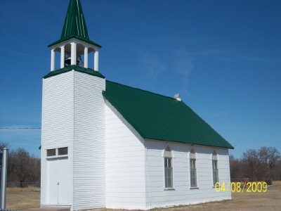
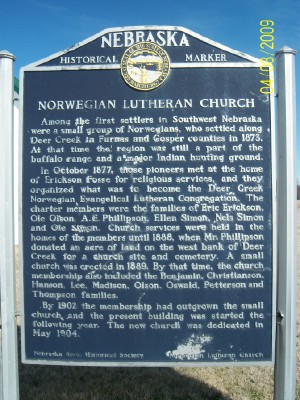
| Description | : | Among the first settlers in Southwest Nebraska were a small group of Norwegians, who settled along Deer Creek in Furnas & Gosper counties in 1873. At that time the region was still a part of the buffalo range and a major Indian hunting ground. In October 1877, those pioneers met at the home of Erickson Fosse for religious services, and they organized what was to become the Deer Creek Norwegian Evangelical Lutheran Congregation. The charter members were the families of Eric Erickson, Ole Olson, A.E. Phillipson, Ellen Simon, Nels Simon and Ole Simon. Church services were held in the homes... Read More |
frequently asked questions (FAQ):
-
Where is Norwegian Lutheran Cemetery?
Norwegian Lutheran Cemetery is located at Holbrook, Furnas County ,Nebraska ,USA.
-
Norwegian Lutheran Cemetery cemetery's updated grave count on graveviews.com?
67 memorials
-
Where are the coordinates of the Norwegian Lutheran Cemetery?
Latitude: 40.3380910
Longitude: -100.0425560
Nearby Cemetories:
1. Miller Cemetery
Elwood, Gosper County, USA
Coordinate: 40.3514980, -100.0374350
2. Holbrook Cemetery
Holbrook, Furnas County, USA
Coordinate: 40.3138000, -100.0045000
3. Saint Matthew Lutheran Cemetery
Elwood, Gosper County, USA
Coordinate: 40.3519000, -99.9630000
4. East Muddy Cemetery
Gosper County, USA
Coordinate: 40.4166985, -99.9614029
5. Arapahoe Cemetery
Arapahoe, Furnas County, USA
Coordinate: 40.3239600, -99.8985500
6. Saint John's Catholic Cemetery
Cambridge, Furnas County, USA
Coordinate: 40.2850000, -100.1817000
7. Fairview Cemetery
Cambridge, Furnas County, USA
Coordinate: 40.2849998, -100.1817017
8. Garfield Cemetery
Furnas County, USA
Coordinate: 40.2491989, -99.8992004
9. Pleasantview Cemetery
Arapahoe, Furnas County, USA
Coordinate: 40.2043991, -99.9669037
10. Stowe Cemetery
Stockville, Frontier County, USA
Coordinate: 40.4900017, -100.0753021
11. Pleasant Grove Cemetery
Gosper County, USA
Coordinate: 40.4664001, -99.9250031
12. Immanuel Lutheran Cemetery
Elwood, Gosper County, USA
Coordinate: 40.4206500, -99.8672000
13. Hammond Cemetery
Frontier County, USA
Coordinate: 40.4002953, -100.2353134
14. Denny Cemetery
Frontier County, USA
Coordinate: 40.4393997, -100.2082977
15. Salem West Cemetery
Frontier County, USA
Coordinate: 40.4968987, -99.9886017
16. Salem East Cemetery
Gosper County, USA
Coordinate: 40.4972000, -99.9803009
17. McGuire Cemetery
Gosper County, USA
Coordinate: 40.4380989, -99.8664017
18. Homerville Cemetery
Gosper County, USA
Coordinate: 40.4668999, -99.8593979
19. Edison Cemetery
Edison, Furnas County, USA
Coordinate: 40.2919006, -99.7902985
20. Stump Cemetery
Furnas County, USA
Coordinate: 40.3478012, -99.7621994
21. Prairie Land Cemetery
Frontier County, USA
Coordinate: 40.4077988, -100.3181000
22. Gammill Cemetery
Frontier County, USA
Coordinate: 40.4580840, -100.2882640
23. Hendley Cemetery
Hendley, Furnas County, USA
Coordinate: 40.1186000, -99.9939000
24. Pleasant Hill Cemetery
Frontier County, USA
Coordinate: 40.5111008, -100.2281036