
| Memorials | : | 1 |
| Location | : | Jefferson County, USA |
| Coordinate | : | 38.0932999, -90.4591980 |
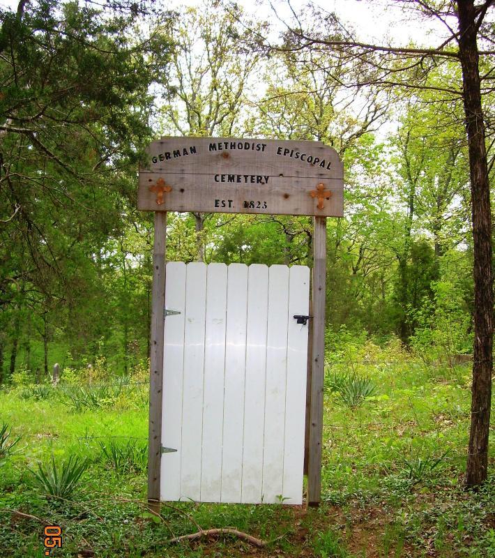
| Description | : | This cemetery was established in 1823 and at the time there was a church there. Years later a railroad was built through where the church and cemetery were, so the church was moved and the cemetery abandoned. The railroad is no longer active through that area and the cemetery is on privately owned property and is not accessible to the public or visible by any road. It is deep in the woods. The new church & cemetery are now called Flucom Dutch Methodist which is located off of Flucom Rd in Jefferson County, MO. |
frequently asked questions (FAQ):
-
Where is Old German Cemetery?
Old German Cemetery is located at Jefferson County ,Missouri ,USA.
-
Old German Cemetery cemetery's updated grave count on graveviews.com?
1 memorials
-
Where are the coordinates of the Old German Cemetery?
Latitude: 38.0932999
Longitude: -90.4591980
Nearby Cemetories:
1. Flucom Dutch Methodist Cemetery
Jefferson County, USA
Coordinate: 38.1041600, -90.4489800
2. Hope United Church of Christ Ebenezer Cemetery
De Soto, Jefferson County, USA
Coordinate: 38.1072006, -90.4831009
3. Acquilla Cole Cemetery
Jefferson County, USA
Coordinate: 38.0778008, -90.4357986
4. Charter Baptist Church Cemetery
Festus, Jefferson County, USA
Coordinate: 38.0814600, -90.4219300
5. Mount Olive Cemetery
De Soto, Jefferson County, USA
Coordinate: 38.0802800, -90.5069900
6. Peter P. McClain Cemetery
Plattin, Jefferson County, USA
Coordinate: 38.0604400, -90.4263100
7. Peter B. Frazier Cemetery
De Soto, Jefferson County, USA
Coordinate: 38.0522220, -90.4719440
8. McMullen Cemetery
Jefferson County, USA
Coordinate: 38.1206017, -90.4171982
9. Benjamin Bradfield Byrd Cemetery
Jefferson County, USA
Coordinate: 38.0950012, -90.4005966
10. McNulty Gravesite
Jefferson County, USA
Coordinate: 38.1391300, -90.4729700
11. James McCormack Cemetery
Plattin, Jefferson County, USA
Coordinate: 38.1264557, -90.4073943
12. McCormack Cemetery
Jefferson County, USA
Coordinate: 38.1264000, -90.4072037
13. Avoca Cemetery
De Soto, Jefferson County, USA
Coordinate: 38.0545807, -90.5121536
14. Sunnyside Cemetery
Festus, Jefferson County, USA
Coordinate: 38.1533012, -90.4653015
15. Lester Cemetery
St. Francois County, USA
Coordinate: 38.0306015, -90.4477997
16. Edwards Cemetery
De Soto, Jefferson County, USA
Coordinate: 38.1095374, -90.5452866
17. McClain Cemetery
Jefferson County, USA
Coordinate: 38.1264000, -90.3796997
18. Dripping Springs Cemetery
Jefferson County, USA
Coordinate: 38.1034600, -90.5483200
19. Rouggly Cemetery
St. Francois County, USA
Coordinate: 38.0097008, -90.4546967
20. Woodlawn Memorial Park
De Soto, Jefferson County, USA
Coordinate: 38.1264000, -90.5655975
21. City Cemetery
De Soto, Jefferson County, USA
Coordinate: 38.1405260, -90.5642440
22. Telegraph School House Cemetery
Festus, Jefferson County, USA
Coordinate: 38.1687700, -90.3836700
23. Sennert Cemetery
Danby, Jefferson County, USA
Coordinate: 38.1072220, -90.3375000
24. Cook Family Graveyard
Jefferson County, USA
Coordinate: 38.1577988, -90.3613968