
| Memorials | : | 0 |
| Location | : | Jefferson County, USA |
| Coordinate | : | 38.1391300, -90.4729700 |
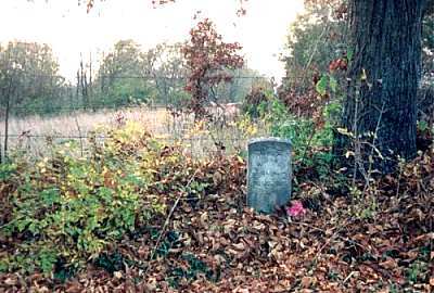
| Description | : | Located in Jefferson County on Chilton Hills road, is the plot of a few graves by an old tree. It is unknown how many are here. I was told when I was younger, that a woman is buried here with her child. She died giving birth to this child. The stone used to mark her spot has been removed. There is another stone, propped up in front of the tree & is a marker for someone. |
frequently asked questions (FAQ):
-
Where is McNulty Gravesite?
McNulty Gravesite is located at Jefferson County ,Missouri ,USA.
-
McNulty Gravesite cemetery's updated grave count on graveviews.com?
0 memorials
-
Where are the coordinates of the McNulty Gravesite?
Latitude: 38.1391300
Longitude: -90.4729700
Nearby Cemetories:
1. Sunnyside Cemetery
Festus, Jefferson County, USA
Coordinate: 38.1533012, -90.4653015
2. Hope United Church of Christ Ebenezer Cemetery
De Soto, Jefferson County, USA
Coordinate: 38.1072006, -90.4831009
3. Flucom Dutch Methodist Cemetery
Jefferson County, USA
Coordinate: 38.1041600, -90.4489800
4. Old German Cemetery
Jefferson County, USA
Coordinate: 38.0932999, -90.4591980
5. McMullen Cemetery
Jefferson County, USA
Coordinate: 38.1206017, -90.4171982
6. James McCormack Cemetery
Plattin, Jefferson County, USA
Coordinate: 38.1264557, -90.4073943
7. McCormack Cemetery
Jefferson County, USA
Coordinate: 38.1264000, -90.4072037
8. Null Cemetery
Hematite, Jefferson County, USA
Coordinate: 38.1947212, -90.4852753
9. Hematite Christian Church Cemetery
Hematite, Jefferson County, USA
Coordinate: 38.1995500, -90.4799300
10. Edwards Cemetery
De Soto, Jefferson County, USA
Coordinate: 38.1095374, -90.5452866
11. Mount Olive Cemetery
De Soto, Jefferson County, USA
Coordinate: 38.0802800, -90.5069900
12. Ogle Cemetery
Hematite, Jefferson County, USA
Coordinate: 38.2011111, -90.5036111
13. Acquilla Cole Cemetery
Jefferson County, USA
Coordinate: 38.0778008, -90.4357986
14. Dripping Springs Cemetery
Jefferson County, USA
Coordinate: 38.1034600, -90.5483200
15. Charter Baptist Church Cemetery
Festus, Jefferson County, USA
Coordinate: 38.0814600, -90.4219300
16. City Cemetery
De Soto, Jefferson County, USA
Coordinate: 38.1405260, -90.5642440
17. Benjamin Bradfield Byrd Cemetery
Jefferson County, USA
Coordinate: 38.0950012, -90.4005966
18. Peaceful Ridge Cemetery
De Soto, Jefferson County, USA
Coordinate: 38.1699300, -90.5565500
19. Woodlawn Memorial Park
De Soto, Jefferson County, USA
Coordinate: 38.1264000, -90.5655975
20. McClain Cemetery
Jefferson County, USA
Coordinate: 38.1264000, -90.3796997
21. Telegraph School House Cemetery
Festus, Jefferson County, USA
Coordinate: 38.1687700, -90.3836700
22. Madison Cemetery
Festus, Jefferson County, USA
Coordinate: 38.1836014, -90.3930969
23. Calvary Cemetery
De Soto, Jefferson County, USA
Coordinate: 38.1413994, -90.5718994
24. Mount Zion Cemetery
Festus, Jefferson County, USA
Coordinate: 38.2014008, -90.4077988