| Memorials | : | 0 |
| Location | : | Wenden, La Paz County, USA |
| Coordinate | : | 34.3013060, -113.4981890 |
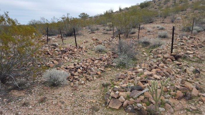
| Description | : | This cemetery is now located in LaPaz Co., in the section formally in Yuma Co. Remote & difficult to locate. It is east of Alamo Lake, north of Wenden, 30 miles from Wayside, Arizona. On the south side of the Santa Maria River where it joins the Big Sandy River. This cemetery is most likely a gold mining camp cemetery. There are 18 graves here, all adult males with one child's, with only one marked for Ernesto Campas. It was located by the Arizona Pioneer & Cemeterys Project, by Bill Bain, Neal DuShane, Ralph... Read More |
frequently asked questions (FAQ):
-
Where is Olea Ranch Cemetery?
Olea Ranch Cemetery is located at Wenden, La Paz County ,Arizona ,USA.
-
Olea Ranch Cemetery cemetery's updated grave count on graveviews.com?
0 memorials
-
Where are the coordinates of the Olea Ranch Cemetery?
Latitude: 34.3013060
Longitude: -113.4981890
Nearby Cemetories:
1. Alamo Crossing East Cemetery
Swansea, La Paz County, USA
Coordinate: 34.3001600, -113.4993700
2. Palmenta Ranch Cemetery
Wenden, La Paz County, USA
Coordinate: 34.2973120, -113.4224420
3. Alamo Crossing West Cemetery
Swansea, La Paz County, USA
Coordinate: 34.2559400, -113.5673500
4. Signal Area Cemetery
Mohave County, USA
Coordinate: 34.4636800, -113.6253700
5. Lopez Ranch Cemetery
Yucca, Mohave County, USA
Coordinate: 34.2357560, -113.7815170
6. Santa Maria Cemetery
Bagdad, Yavapai County, USA
Coordinate: 34.3708600, -113.1798600
7. Swansea North Cemetery
Swansea, La Paz County, USA
Coordinate: 34.1734200, -113.8435600
8. Swansea South Cemetery
Swansea, La Paz County, USA
Coordinate: 34.1695720, -113.8473390
9. Noli Cemetery
Wikieup, Mohave County, USA
Coordinate: 34.6734040, -113.5735350
10. Sandy Cemetery
Mohave County, USA
Coordinate: 34.6860008, -113.5810013
11. Cullings Well Cemetery
Salome, La Paz County, USA
Coordinate: 33.9095150, -113.3992410
12. Masten Family Cemetery
Wikieup, Mohave County, USA
Coordinate: 34.7050018, -113.6090012
13. Wenden Cemetery
Wenden, La Paz County, USA
Coordinate: 33.8187500, -113.5334440
14. Eagle Eye Cemetery
Aguila, Maricopa County, USA
Coordinate: 33.8958817, -113.1778641
15. Camp Date Creek Pioneer Military Cemetery
Prescott, Yavapai County, USA
Coordinate: 34.2668600, -112.9081100
16. Cedar Cemetery
Mohave County, USA
Coordinate: 34.7664337, -113.7757874
17. Dick Wick Hall Gravesite
Salome, La Paz County, USA
Coordinate: 33.7828000, -113.6181000
18. Congress Cemetery
Congress, Yavapai County, USA
Coordinate: 34.1897011, -112.8542023
19. Thompson Valley Cemetery
Yava, Yavapai County, USA
Coordinate: 34.4709350, -112.8712280
20. Old Congress Cemetery
Congress, Yavapai County, USA
Coordinate: 34.1938600, -112.8502700
21. Bouse Cemetery
Bouse, La Paz County, USA
Coordinate: 33.9416000, -114.0021000
22. Harrisburg Cemetery
La Paz County, USA
Coordinate: 33.7346992, -113.5447006
23. John F Pritt Gravesite
Earp, San Bernardino County, USA
Coordinate: 34.2576600, -114.2259500
24. Wickenburg Massacre Site
Wickenburg, Maricopa County, USA
Coordinate: 33.9893000, -112.8536300

