| Memorials | : | 1 |
| Location | : | Whittier, Los Angeles County, USA |
| Coordinate | : | 33.9452300, -118.0511700 |
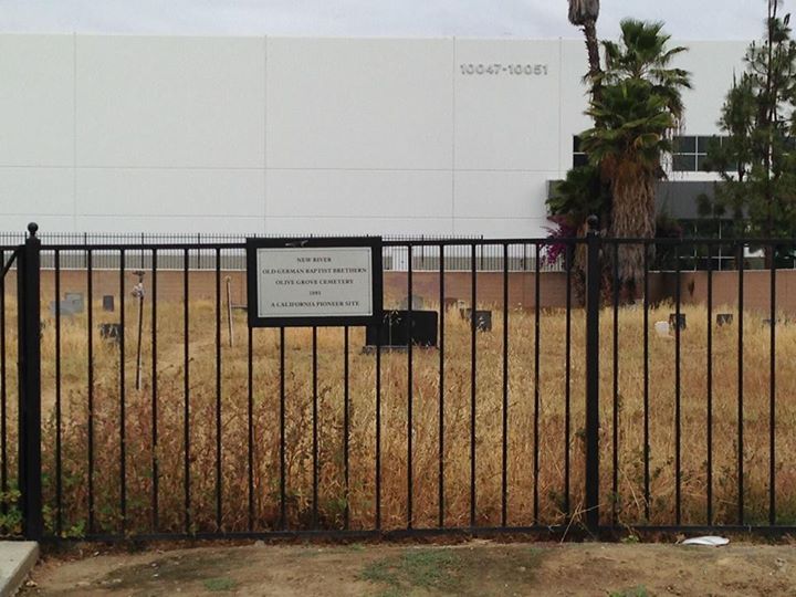
| Description | : | Founded in 1896 by a colony of German Baptists known as “Dunkers” (due to their method of baptism). In 1972, the Dunkers moved to Modesto. At one point the Bible Missionary Church owned and maintained the cemetery, but as of 2005, the church had been torn down and ownership of the cemetery is unclear. As of October 2009, the California Cemetery & Funeral Bureau has no record of a Certificate of Authority (Cemetery) on their database. |
frequently asked questions (FAQ):
-
Where is Olive Grove Cemetery?
Olive Grove Cemetery is located at 10135 S Painter Ave. Whittier, Los Angeles County ,California , 90605USA.
-
Olive Grove Cemetery cemetery's updated grave count on graveviews.com?
1 memorials
-
Where are the coordinates of the Olive Grove Cemetery?
Latitude: 33.9452300
Longitude: -118.0511700
Nearby Cemetories:
1. Cinco Camp Burial Grounds
Cantil, Kern County, USA
Coordinate: 33.9277710, -118.0649960
2. Norwalk State Hospital Cemetery
Norwalk, Los Angeles County, USA
Coordinate: 33.9277710, -118.0649960
3. Little Lake Cemetery
Santa Fe Springs, Los Angeles County, USA
Coordinate: 33.9317900, -118.0779100
4. Paradise Memorial Park
Santa Fe Springs, Los Angeles County, USA
Coordinate: 33.9354540, -118.0869900
5. Broadway Cemetery
Whittier, Los Angeles County, USA
Coordinate: 33.9868088, -118.0460434
6. Mount Olive Cemetery
Whittier, Los Angeles County, USA
Coordinate: 33.9869003, -118.0453033
7. Olive Lawn Memorial Park
La Mirada, Los Angeles County, USA
Coordinate: 33.9038700, -118.0114400
8. Young Israel Cemetery
Norwalk, Los Angeles County, USA
Coordinate: 33.9071000, -118.1081300
9. Saint Marks Episcopal Church Columbarium
Downey, Los Angeles County, USA
Coordinate: 33.9491800, -118.1271200
10. Rose Hills Memorial Park
Whittier, Los Angeles County, USA
Coordinate: 34.0139900, -118.0253400
11. Mount Olive Memorial Park
Los Angeles, Los Angeles County, USA
Coordinate: 33.9795280, -118.1349300
12. Russian Molokan Cemetery
Commerce, Los Angeles County, USA
Coordinate: 33.9798600, -118.1356400
13. Park Lawn Memorial Park
Commerce, Los Angeles County, USA
Coordinate: 33.9734200, -118.1427500
14. Downey District Cemetery
Downey, Los Angeles County, USA
Coordinate: 33.9102783, -118.1399994
15. Artesia Cemetery
Cerritos, Los Angeles County, USA
Coordinate: 33.8717003, -118.0958023
16. Mount Carmel Cemetery
Commerce, Los Angeles County, USA
Coordinate: 33.9736300, -118.1443500
17. Los Angeles County Farm Cemetery
Downey, Los Angeles County, USA
Coordinate: 33.9235609, -118.1694582
18. El Campo Santo Cemetery
Industry, Los Angeles County, USA
Coordinate: 34.0182300, -117.9630500
19. Saint Josephs Episcopal Church Columbarium
Buena Park, Orange County, USA
Coordinate: 33.8415590, -118.0280360
20. Resurrection Cemetery
Montebello, Los Angeles County, USA
Coordinate: 34.0429993, -118.1007004
21. Forest Lawn Memorial Park
Cypress, Orange County, USA
Coordinate: 33.8339005, -118.0560989
22. First Presbyterian Church Memorial Gardens
Fullerton, Orange County, USA
Coordinate: 33.8788600, -117.9417400
23. Loma Vista Memorial Park
Fullerton, Orange County, USA
Coordinate: 33.9016991, -117.9167023
24. Long Beach Police Academy K-9 Cemetery
Long Beach, Los Angeles County, USA
Coordinate: 33.8274000, -118.0895300


