| Memorials | : | 0 |
| Location | : | Olivia, Calhoun County, USA |
| Coordinate | : | 28.6482270, -96.4509940 |
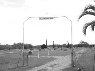
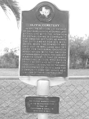
| Description | : | Olivia, Texas, is just a short drive south of the intersection of Texas State Highway 35 and Texas State Highway 172, fourteen miles east of Port Lavaca. Olivia sits on the southwestern tip of a peninsula bound by Keller Bay to its west, Carancahua Bay to its east, and Matagorda Bay to its south. It's a rural setting of pastures, farmhouses, bay houses, and fishing piers. The community of Olivia was established in 1892 as a Swedish Lutheran colony led by Carl J.E. Haterious of Illinois; he bought 13,565 acres from J.D. Mitchell and named the settlement for his wife... Read More |
frequently asked questions (FAQ):
-
Where is Olivia Cemetery?
Olivia Cemetery is located at Olivia, Calhoun County ,Texas ,USA.
-
Olivia Cemetery cemetery's updated grave count on graveviews.com?
0 memorials
-
Where are the coordinates of the Olivia Cemetery?
Latitude: 28.6482270
Longitude: -96.4509940
Nearby Cemetories:
1. Old Town Cemetery
Indianola, Calhoun County, USA
Coordinate: 28.5443940, -96.5226170
2. Zimmermann Cemetery
Indianola, Calhoun County, USA
Coordinate: 28.5440550, -96.5443430
3. Indianola Cemetery
Indianola, Calhoun County, USA
Coordinate: 28.5191994, -96.5092010
4. Ranger Cemetery
Port Lavaca, Calhoun County, USA
Coordinate: 28.6220610, -96.6250670
5. Port Lavaca Cemetery
Port Lavaca, Calhoun County, USA
Coordinate: 28.6087080, -96.6253780
6. Little Mary's Grave
Calhoun County, USA
Coordinate: 28.5748005, -96.6464767
7. Six Mile Cemetery
Port Lavaca, Calhoun County, USA
Coordinate: 28.6776650, -96.6861350
8. Port O'Connor Cemetery
Port O'Connor, Calhoun County, USA
Coordinate: 28.4344260, -96.4450480
9. Hatch Cemetery
Port Lavaca, Calhoun County, USA
Coordinate: 28.5885544, -96.7007141
10. Clark Cemetery
Calhoun County, USA
Coordinate: 28.6028004, -96.7071991
11. Moses Johnson Cemetery
Port Lavaca, Calhoun County, USA
Coordinate: 28.6192226, -96.7251358
12. Greenlawn Gardens
Port Lavaca, Calhoun County, USA
Coordinate: 28.6041060, -96.7288690
13. Fort Esperanza Burying Ground
Matagorda Island, Calhoun County, USA
Coordinate: 28.3927000, -96.4120600
14. Long Mott Cemetery
Long Mott, Calhoun County, USA
Coordinate: 28.5024600, -96.7447230
15. Matagorda Lighthouse Cemetery
Matagorda Island, Calhoun County, USA
Coordinate: 28.3451805, -96.4167023
16. Seadrift Cemetery
Seadrift, Calhoun County, USA
Coordinate: 28.4249992, -96.6892014
17. Stiernberg Cemetery
Seadrift, Calhoun County, USA
Coordinate: 28.4008007, -96.6872025
18. Jordan
Long Mott, Calhoun County, USA
Coordinate: 28.4451850, -96.7541890
19. Sonneman Cemetery
Long Mott, Calhoun County, USA
Coordinate: 28.4556180, -96.7777280
20. Free System Cemetery
Brazoria County, USA
Coordinate: 29.0319004, -95.8731003
21. Cologne Cemetery
Cologne, Goliad County, USA
Coordinate: 28.7125530, -97.1843310
22. Lott Cemetery
Goliad County, USA
Coordinate: 28.6067009, -97.2125015
23. Noble Cemetery
Goliad County, USA
Coordinate: 28.7000008, -97.2127991
24. Berger Cemetery
Goliad County, USA
Coordinate: 28.8185997, -97.2042007


