
| Memorials | : | 0 |
| Location | : | Manutuke, Gisborne District, New Zealand |
| Coordinate | : | -38.6779310, 177.9084450 |
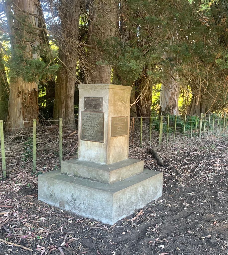
| Description | : | This is a small family burial ground sited near trees and the Te Arai river on Opou Station, a private farm near Manutuke, 13 kms south west of Gisborne. The Read Bloomfield family monument has the following inscriptions: - Captain GEORGE EDWARD READ, died 23 February 1878; THOMAS EDWARD READ BLOOMFIELD, nephew of Captain Read, died 12 October 1890 aged 31 years, and his sons; THOMAS EDWARD READ BLOOMFIELD, died 7 May 1910 aged 24 years, GEORGE LUCAS READ BLOOMFIELD, died 27 October 1889 aged 6 months. JOHN EDWARDS, died 29 October 1880, and his Wife, a Sister of Captain... Read More |
frequently asked questions (FAQ):
-
Where is Opou Station Cemetery?
Opou Station Cemetery is located at 95 Whakato Road Manutuke, Gisborne District ,Gisborne ,New Zealand.
-
Opou Station Cemetery cemetery's updated grave count on graveviews.com?
0 memorials
-
Where are the coordinates of the Opou Station Cemetery?
Latitude: -38.6779310
Longitude: 177.9084450
Nearby Cemetories:
1. Opou Tuarakena Cemetery
Manutuke, Gisborne District, New Zealand
Coordinate: -38.6744759, 177.9095277
2. Manutuke Churchyard Urupā
Manutuke, Gisborne District, New Zealand
Coordinate: -38.6815360, 177.9080180
3. Manutuke Whakato Urupā
Manutuke, Gisborne District, New Zealand
Coordinate: -38.6843390, 177.9073690
4. Patutahi Cemetery
Gisborne, Gisborne District, New Zealand
Coordinate: -38.6199300, 177.8955600
5. Makaraka Cemetery
Gisborne, Gisborne District, New Zealand
Coordinate: -38.6482600, 177.9803200
6. Taruheru Cemetery
Gisborne, Gisborne District, New Zealand
Coordinate: -38.6428900, 177.9802300
7. Waerenga a hika Urupā
Gisborne, Gisborne District, New Zealand
Coordinate: -38.5954100, 177.9263500
8. Paramanihi Waihirere Cemetery
Gisborne, Gisborne District, New Zealand
Coordinate: -38.5791250, 177.9488450
9. Ormond Cemetery
Ormond, Gisborne District, New Zealand
Coordinate: -38.5526480, 177.9279330
10. Wainui
Gisborne District, New Zealand
Coordinate: -38.6950000, 178.0707400
11. Pouawa Urupā
Whangara, Gisborne District, New Zealand
Coordinate: -38.6085500, 178.1825900
12. Whangara Urupā
Whangara, Gisborne District, New Zealand
Coordinate: -38.5716800, 178.2310400
13. Tapuae o te Rangi Urupā
Whatatutu, Gisborne District, New Zealand
Coordinate: -38.3791200, 177.8134180
14. Nuhaka North Cemetery
Morere, Wairoa District, New Zealand
Coordinate: -38.9797100, 177.7944300
15. Rakauroa Cemetery
Matawai, Gisborne District, New Zealand
Coordinate: -38.4358900, 177.5711400
16. Arataiha Urupā
Nuhaka, Wairoa District, New Zealand
Coordinate: -39.0201020, 177.7361770
17. Opoutama Cemetery
Mahia, Wairoa District, New Zealand
Coordinate: -39.0550780, 177.8405420
18. Manawarakau Urupā
Nuhaka, Wairoa District, New Zealand
Coordinate: -39.0371870, 177.7262650
19. Nuhaka Public Cemetery
Nuhaka, Wairoa District, New Zealand
Coordinate: -39.0396540, 177.7267440
20. Whaanga Family Cemetery
Nuhaka, Wairoa District, New Zealand
Coordinate: -39.0402910, 177.7253800
21. Kaiuku Marae Urupā
Mahia, Wairoa District, New Zealand
Coordinate: -39.0823112, 177.9086516
22. Kaitamure Urupā
Nuhaka, Wairoa District, New Zealand
Coordinate: -39.0465570, 177.6809660
23. Kaiuku Marae Urupā
Mahia, Wairoa District, New Zealand
Coordinate: -39.0956100, 177.9460200
24. Kohimarama Urupā
Tolaga Bay, Gisborne District, New Zealand
Coordinate: -38.3791770, 178.3007610