| Memorials | : | 0 |
| Location | : | Pannonhalma, Pannonhalmi járás, Hungary |
| Coordinate | : | 47.5527780, 17.7611110 |
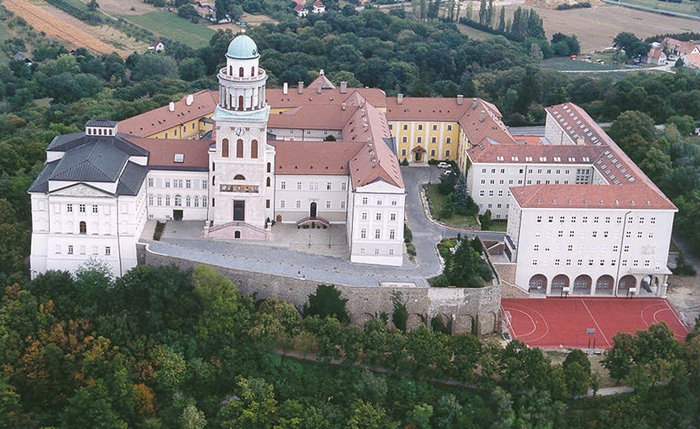
| Description | : | AKA: Pannonhalmi Főapátság The Benedictine Pannonhalma Archabbey is the most notable landmark in Pannonhalma and one of the oldest historical monuments in Hungary. It was founded as the first Hungarian Benedictine monastery in 996 by Prince Géza. The monastery was built in honour of Saint Martin of Tours. Géza's son, King Stephen I donated estates and privilege to the monastery. The basilica was built in the 13th century. The abbey has a large library (more than 300,000 volumes). The monastery became an archabbey in 1541 and as a result of Ottoman incursions into Europe in the 16th and 17th centuries, it... Read More |
frequently asked questions (FAQ):
-
Where is Pannonhalma Archabbey?
Pannonhalma Archabbey is located at Pannonhalma, Pannonhalmi járás ,Gyor-Moson-Sopron ,Hungary.
-
Pannonhalma Archabbey cemetery's updated grave count on graveviews.com?
0 memorials
-
Where are the coordinates of the Pannonhalma Archabbey?
Latitude: 47.5527780
Longitude: 17.7611110
Nearby Cemetories:
1. Nyúl Temető Cemetery
Nyúl, Győri járás, Hungary
Coordinate: 47.5966841, 17.6866333
2. Nádorvárosi köztemető
Győr, Győri járás, Hungary
Coordinate: 47.6618460, 17.6432200
3. Cathedral of the Assumption of the Blessed Virgin
Győr, Győri járás, Hungary
Coordinate: 47.6889760, 17.6313925
4. Jewish Cemetery of Gyor
Győr, Győri járás, Hungary
Coordinate: 47.6896744, 17.6126499
5. Bakonyszentkirályi temető
Bakonyszentkirály, Zirci járás, Hungary
Coordinate: 47.3729858, 17.8797970
6. Bakonyszentkirály, Jeste hegyi temető
Bakonyszentkirály, Zirci járás, Hungary
Coordinate: 47.3621746, 17.8811728
7. Cseszneki temető
Csesznek, Zirci járás, Hungary
Coordinate: 47.3497943, 17.8869095
8. Malomsok
Malomsok, Pápai járás, Hungary
Coordinate: 47.4691820, 17.4311830
9. Kónyi temetö
Kóny, Csornai járás, Hungary
Coordinate: 47.6288457, 17.3610604
10. Nagyesztergári temető
Nagyesztergár, Zirci járás, Hungary
Coordinate: 47.2845445, 17.9002411
11. Csetény cemetery (temetö)
Csetény, Zirci járás, Hungary
Coordinate: 47.3209920, 18.0046660
12. Rábapordányi temető
Rábapordány, Csornai járás, Hungary
Coordinate: 47.5598478, 17.3336062
13. Ciszterci Apátság Zirci
Zirc, Zirci járás, Hungary
Coordinate: 47.2636930, 17.8736820
14. Bakonybéli temető
Bakonybél, Zirci járás, Hungary
Coordinate: 47.2542113, 17.7277002
15. Alsóvárosi temető , Pápa
Pápa, Pápai járás, Hungary
Coordinate: 47.3201530, 17.4745390
16. Barbacsi temető
Barbacs, Csornai járás, Hungary
Coordinate: 47.6469804, 17.2934784
17. Jewish cemetery, Mór.
Mór, Móri járás, Hungary
Coordinate: 47.3700290, 18.1954950
18. Tési temető
Tés, Várpalotai járás, Hungary
Coordinate: 47.2564797, 18.0249342
19. Őrangyal temető új temető Csorna
Csorna, Csornai járás, Hungary
Coordinate: 47.6223905, 17.2527875
20. Csorna Jewish Cemetery
Csorna, Csornai járás, Hungary
Coordinate: 47.6072310, 17.2438900
21. Szent Antal Church
Csorna, Csornai járás, Hungary
Coordinate: 47.6107979, 17.2431793
22. Szent Kereszt templom
Ganna, Pápai járás, Hungary
Coordinate: 47.2327400, 17.5304500
23. Jewish Cemetery
Tata, Tatai járás, Hungary
Coordinate: 47.6387840, 18.3183660
24. Cemetery in Magyarpolány
Magyarpolány, Ajkai járás, Hungary
Coordinate: 47.1732035, 17.5488605

