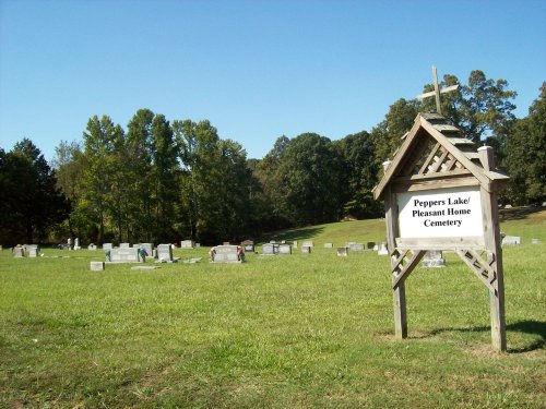
| Memorials | : | 1 |
| Location | : | Peppers Lake, Prairie County, USA |
| Coordinate | : | 34.7386093, -91.4155579 |
| Description | : | SE of Devalls Bluff, on 302, between Alexander Rd and Beeler Rd. This cemetery is also known as the Pleasant Home Cemetery. Prairie County, Section 35, Township 1 North, Range 4 West. Peppers Lake Church of Christ is adjacent to the cemetery. |
frequently asked questions (FAQ):
-
Where is Peppers Lake Cemetery?
Peppers Lake Cemetery is located at Hwy 302 Peppers Lake, Prairie County ,Arkansas ,USA.
-
Peppers Lake Cemetery cemetery's updated grave count on graveviews.com?
1 memorials
-
Where are the coordinates of the Peppers Lake Cemetery?
Latitude: 34.7386093
Longitude: -91.4155579
Nearby Cemetories:
1. Pleasant Home Cemetery
Prairie County, USA
Coordinate: 34.7386017, -91.4163971
2. Oakland Cemetery
De Valls Bluff, Prairie County, USA
Coordinate: 34.7855139, -91.4683028
3. Harris Cemetery
Biscoe, Prairie County, USA
Coordinate: 34.8119011, -91.4169006
4. Biscoe Cemetery
Biscoe, Prairie County, USA
Coordinate: 34.8119011, -91.4191971
5. Harrison Cemetery
Biscoe, Prairie County, USA
Coordinate: 34.8120320, -91.4171690
6. Roe Cemetery
Roe, Monroe County, USA
Coordinate: 34.6354000, -91.3829500
7. Shady Grove Cemetery North
Clarendon, Monroe County, USA
Coordinate: 34.7152300, -91.2875900
8. Shady Grove Cemetery
Clarendon, Monroe County, USA
Coordinate: 34.7135900, -91.2873100
9. Webb's Cemetery
Roe, Monroe County, USA
Coordinate: 34.6319900, -91.4423600
10. Bateman Cemetery
Clarendon, Monroe County, USA
Coordinate: 34.7022018, -91.2817001
11. Saint Paul Upper Hill Cemetery
Prairie County, USA
Coordinate: 34.6219300, -91.3840690
12. Saint Paul Cemetery
Roe, Monroe County, USA
Coordinate: 34.6218987, -91.3839035
13. Czech National Cemetery
Prairie County, USA
Coordinate: 34.7444000, -91.5610962
14. Old Bethel Cemetery
Prairie County, USA
Coordinate: 34.8072014, -91.5400009
15. Roc Roe Cemetery
Monroe County, USA
Coordinate: 34.6232986, -91.3480988
16. Choctaw Cemetery
Monroe County, USA
Coordinate: 34.8025017, -91.2703018
17. Hazen Cemetery
Hazen, Prairie County, USA
Coordinate: 34.7966995, -91.5663986
18. Mount Zion Cemetery
Clarendon, Monroe County, USA
Coordinate: 34.6933899, -91.2543716
19. Prairie Chapel Cemetery
Hazen, Prairie County, USA
Coordinate: 34.7966995, -91.5772018
20. New Hope Cemetery
Monroe County, USA
Coordinate: 34.7616090, -91.2356670
21. Philadelphia Cemetery
Monroe County, USA
Coordinate: 34.8236008, -91.2538986
22. Slovak Catholic Cemetery
Slovak, Prairie County, USA
Coordinate: 34.6449167, -91.5775694
23. Green Grove Cemetery
Prairie County, USA
Coordinate: 34.8518982, -91.5653000
24. Zion Lutheran Cemetery
Ulm, Prairie County, USA
Coordinate: 34.5769005, -91.4756012

