| Memorials | : | 14 |
| Location | : | Perlee, Jefferson County, USA |
| Coordinate | : | 41.0805750, -91.8993380 |
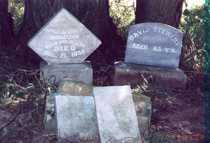
| Description | : | This cemetery has actually been plowed over and these stones from the cemetery have been moved to a small grove of thorny locust trees to the right of a gravel road in a field south of a residence at 1539 Olive. Thanks to Richard Thompson and Verda Baird who gave me permission to use these photos. |
frequently asked questions (FAQ):
-
Where is Perlee Cemetery?
Perlee Cemetery is located at Perlee, Jefferson County ,Iowa ,USA.
-
Perlee Cemetery cemetery's updated grave count on graveviews.com?
7 memorials
-
Where are the coordinates of the Perlee Cemetery?
Latitude: 41.0805750
Longitude: -91.8993380
Nearby Cemetories:
1. Wheeler Cemetery
Jefferson County, USA
Coordinate: 41.0797000, -91.9185500
2. Westenhaver Family Cemetery
Perlee, Jefferson County, USA
Coordinate: 41.0968240, -91.8829110
3. Antioch Cemetery
Fairfield, Jefferson County, USA
Coordinate: 41.1002998, -91.9147034
4. Upper Richwoods Cemetery
Salina, Jefferson County, USA
Coordinate: 41.0602989, -91.8807983
5. Moyer Cemetery
Fairfield, Jefferson County, USA
Coordinate: 41.1046982, -91.9330978
6. Switzer Cemetery
Fairfield, Jefferson County, USA
Coordinate: 41.0368996, -91.9096985
7. Walnut Creek Friends Cemetery
Pleasant Plain, Jefferson County, USA
Coordinate: 41.1237500, -91.8747500
8. Chillcott Family Cemetery
Jefferson County, USA
Coordinate: 41.0558000, -91.8286300
9. Salina Cemetery
Salina, Jefferson County, USA
Coordinate: 41.0419006, -91.8330994
10. McDowell Cemetery
Fairfield, Jefferson County, USA
Coordinate: 41.1380997, -91.9460983
11. Saint Josephs Cemetery
Pleasant Plain, Jefferson County, USA
Coordinate: 41.1357994, -91.8463974
12. Lower Richwoods Cemetery
Salina, Jefferson County, USA
Coordinate: 41.0882000, -91.8085000
13. Polishville Cemetery
East Pleasant Plain, Jefferson County, USA
Coordinate: 41.1116982, -91.8131027
14. Friends Cemetery
Pleasant Plain, Jefferson County, USA
Coordinate: 41.1478004, -91.8636017
15. Howard Grove Cemetery
Jefferson County, USA
Coordinate: 41.1488991, -91.9419022
16. Evergreen Cemetery
Fairfield, Jefferson County, USA
Coordinate: 41.0138600, -91.9562100
17. Old Fairfield Cemetery
Fairfield, Jefferson County, USA
Coordinate: 41.0148000, -91.9598000
18. Bethesda Cemetery
Fairfield, Jefferson County, USA
Coordinate: 41.0019000, -91.8796000
19. Peterson Cemetery
Lockridge, Jefferson County, USA
Coordinate: 41.0393982, -91.8075027
20. Memorial Lawn Cemetery
Fairfield, Jefferson County, USA
Coordinate: 41.0068000, -91.9805000
21. Saints Peter and Paul Catholic Cemetery
Jefferson County, USA
Coordinate: 41.1088982, -91.7731018
22. New Sweden Baptist Cemetery
Jefferson County, USA
Coordinate: 41.0242004, -91.7857971
23. Bradshaw Cemetery
Jefferson County, USA
Coordinate: 40.9766998, -91.9032974
24. Hope Lutheran Cemetery
Germanville, Jefferson County, USA
Coordinate: 41.0943985, -91.7593994

