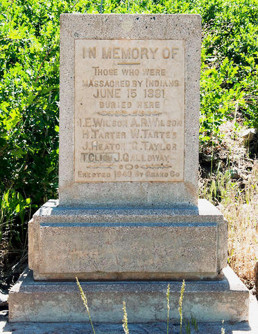
| Memorials | : | 0 |
| Location | : | Castle Valley, Grand County, USA |
| Coordinate | : | 38.5662920, -109.3048520 |
| Description | : | From the Grand Junction Sentinel, written by Kathy Jordan: Pinhook battleground is the southeastern Utah site of the largest and most tragic Indian-white confrontation ever in terms of numbers killed. The Pinhook Battle took place on June 15, 1881, just three months before the town of Grand Junction incorporated. The Meeker Massacre had been fought two years before. In 1940 Jordan Bean, the only remaining survivor of the Pinhook Battle, recounted the event in a letter to the Moab Times-Independent. Trouble between the cattlemen and Indians began at Burnt Cabin Springs, some 35 miles west of Dolores, about two weeks before the battle on... Read More |
frequently asked questions (FAQ):
-
Where is Pinhook Battle Site Cemetery?
Pinhook Battle Site Cemetery is located at Castle Valley, Grand County ,Utah ,USA.
-
Pinhook Battle Site Cemetery cemetery's updated grave count on graveviews.com?
0 memorials
-
Where are the coordinates of the Pinhook Battle Site Cemetery?
Latitude: 38.5662920
Longitude: -109.3048520
Nearby Cemetories:
1. Doles Family Cemetery
Grand County, USA
Coordinate: 38.6004800, -109.3099300
2. Castleton Cemetery
Grand County, USA
Coordinate: 38.6071000, -109.3203000
3. Miners Basin Cemetery
Moab, Grand County, USA
Coordinate: 38.5400800, -109.2554700
4. Castle Valley Cemetery
Castle Valley, Grand County, USA
Coordinate: 38.6346000, -109.4041000
5. Sunset Memorial Gardens
Moab, Grand County, USA
Coordinate: 38.5332985, -109.4997025
6. Red Cliffs Cemetery
Moab, Grand County, USA
Coordinate: 38.6791500, -109.4473500
7. Grand Valley Cemetery
Moab, Grand County, USA
Coordinate: 38.5653000, -109.5322037
8. Peterson Family Cemetery
Moab, Grand County, USA
Coordinate: 38.5648000, -109.5332700
9. Hole 'n the Rock Cemetery
Monticello, San Juan County, USA
Coordinate: 38.3891930, -109.4547690
10. Eva Turner Gravesite
Grand County, USA
Coordinate: 38.8090500, -109.2908300
11. La Sal Cemetery
La Sal, San Juan County, USA
Coordinate: 38.3092000, -109.2610000
12. Paradox Cemetery
Paradox, Montrose County, USA
Coordinate: 38.3608017, -108.9458008
13. Rockland Ranch Cemetery
La Sal Junction, San Juan County, USA
Coordinate: 38.2278500, -109.4598350
14. Home of Truth Cemetery
Dry Valley, San Juan County, USA
Coordinate: 38.0598500, -109.4044900
15. Thompson Springs Cemetery
Grand County, USA
Coordinate: 38.9706001, -109.7221985
16. Price Burial Site
Westwater, Grand County, USA
Coordinate: 39.0805950, -109.1112940
17. Sego Cemetery
Sego, Grand County, USA
Coordinate: 39.0235000, -109.7108000
18. Poverty Flat Cemetery
Egnar, San Miguel County, USA
Coordinate: 38.0430400, -108.9150400
19. Glade Park Cemetery
Mesa County, USA
Coordinate: 39.0074997, -108.7382965
20. Nucla Cemetery
Nucla, Montrose County, USA
Coordinate: 38.2792015, -108.5635986
21. Little Park Cemetery
Grand Junction, Mesa County, USA
Coordinate: 38.9863500, -108.6604500
22. Burns Cemetery
Egnar, San Miguel County, USA
Coordinate: 37.9098740, -109.0136871
23. Monticello City Cemetery
Monticello, San Juan County, USA
Coordinate: 37.8683014, -109.3300018
24. Hardman Family Cemetery
San Miguel County, USA
Coordinate: 37.9944200, -108.7210200

