
| Memorials | : | 0 |
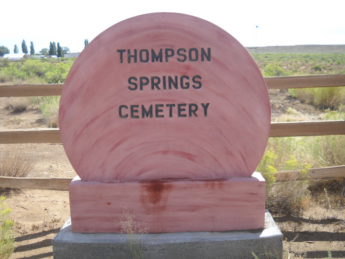
| Location | : | Grand County, USA |
| Coordinate | : | 38.9706001, -109.7221985 |
frequently asked questions (FAQ):
-
Where is Thompson Springs Cemetery?
Thompson Springs Cemetery is located at Grand County ,Utah ,USA.
-
Thompson Springs Cemetery cemetery's updated grave count on graveviews.com?
0 memorials
-
Where are the coordinates of the Thompson Springs Cemetery?
Latitude: 38.9706001
Longitude: -109.7221985

Nearby Cemetories:
1. Sego Cemetery
Sego, Grand County, USA
Coordinate: 39.0235000, -109.7108000
2. Elgin Cemetery
Grand County, USA
Coordinate: 39.0157400, -110.1348300
3. Green River Cemetery
Green River, Emery County, USA
Coordinate: 38.9973100, -110.1702000
4. Red Cliffs Cemetery
Moab, Grand County, USA
Coordinate: 38.6791500, -109.4473500
5. Eva Turner Gravesite
Grand County, USA
Coordinate: 38.8090500, -109.2908300
6. Castle Valley Cemetery
Castle Valley, Grand County, USA
Coordinate: 38.6346000, -109.4041000
7. Grand Valley Cemetery
Moab, Grand County, USA
Coordinate: 38.5653000, -109.5322037
8. Peterson Family Cemetery
Moab, Grand County, USA
Coordinate: 38.5648000, -109.5332700
9. Sunset Memorial Gardens
Moab, Grand County, USA
Coordinate: 38.5332985, -109.4997025
10. Castleton Cemetery
Grand County, USA
Coordinate: 38.6071000, -109.3203000
11. Price Burial Site
Westwater, Grand County, USA
Coordinate: 39.0805950, -109.1112940
12. Doles Family Cemetery
Grand County, USA
Coordinate: 38.6004800, -109.3099300
13. Pinhook Battle Site Cemetery
Castle Valley, Grand County, USA
Coordinate: 38.5662920, -109.3048520
14. Miners Basin Cemetery
Moab, Grand County, USA
Coordinate: 38.5400800, -109.2554700
15. Woodside Cemetery
Woodside, Emery County, USA
Coordinate: 39.2689018, -110.3563995
16. Hole 'n the Rock Cemetery
Monticello, San Juan County, USA
Coordinate: 38.3891930, -109.4547690
17. Tavaputs Ranch Cemetery
Carbon County, USA
Coordinate: 39.5083500, -110.1804900
18. La Sal Cemetery
La Sal, San Juan County, USA
Coordinate: 38.3092000, -109.2610000
19. Glade Park Cemetery
Mesa County, USA
Coordinate: 39.0074997, -108.7382965
20. Rockland Ranch Cemetery
La Sal Junction, San Juan County, USA
Coordinate: 38.2278500, -109.4598350
21. Sunnyside Power Plant Cemetery
Sunnyside, Carbon County, USA
Coordinate: 39.5461081, -110.3894893
22. Valley View Cemetery
Sunnyside, Carbon County, USA
Coordinate: 39.5494003, -110.4011002
23. East Carbon Cemetery
East Carbon City, Carbon County, USA
Coordinate: 39.5487602, -110.4036827
24. Elmwood Cemetery
Fruita, Mesa County, USA
Coordinate: 39.1739006, -108.7339020