
| Memorials | : | 21 |
| Location | : | Maken, Harrison County, USA |
| Coordinate | : | 39.2870580, -80.4877280 |
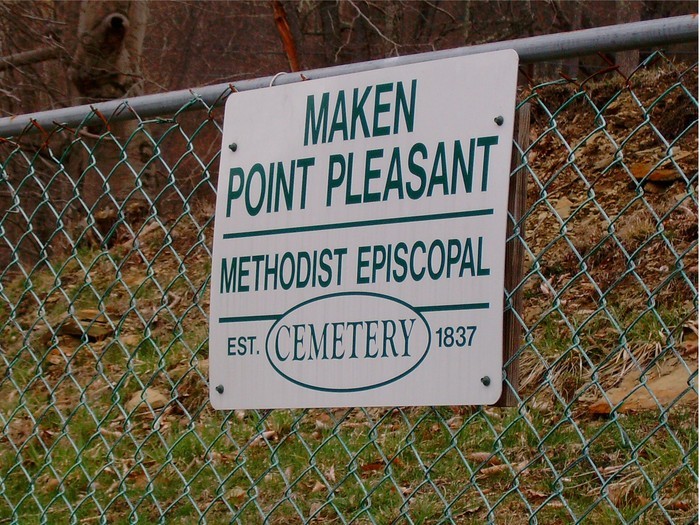
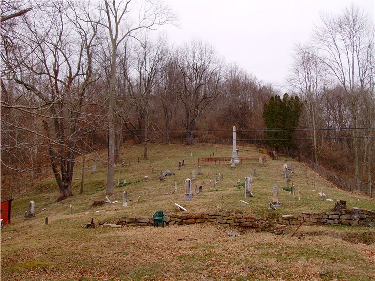
| Description | : | ~ A (restored) cemetery where early Virginia pioneers and war veterans are peacefully, and since 2004, respectively at rest! ~ History: Maken/Point Pleasant Methodist Episcopal church and cemetery were reportedly created in 1837 as second church in Tenmile district, a branch of the old Wilsonburg circuit, reportedly first built by Manley Morris of hewn logs, named Mount Morris Methodist Episcopal church and cemetery. This occurred following construction of Northwestern Pike (later, 3146 mile, U S Highway #50) to Parkersburg, opening Harrison county for development. Church location was on its northerly side, just east of what became Lynchburg, with railroad... Read More |
frequently asked questions (FAQ):
-
Where is Point Pleasant Cemetery?
Point Pleasant Cemetery is located at Maken, Harrison County ,West Virginia ,USA.
-
Point Pleasant Cemetery cemetery's updated grave count on graveviews.com?
12 memorials
-
Where are the coordinates of the Point Pleasant Cemetery?
Latitude: 39.2870580
Longitude: -80.4877280
Nearby Cemetories:
1. Enon Church Cemetery
Bristol, Harrison County, USA
Coordinate: 39.2935982, -80.5057983
2. Shahan Cemetery
Flinderation, Harrison County, USA
Coordinate: 39.3069000, -80.4942017
3. Coplin Church Cemetery
Salem, Harrison County, USA
Coordinate: 39.2636420, -80.4861850
4. Marshville Cemetery
Marshville, Harrison County, USA
Coordinate: 39.3232994, -80.4664001
5. Pleasant Grove Methodist Cemetery
Bristol, Harrison County, USA
Coordinate: 39.3005981, -80.5382996
6. Reynolds Cemetery
Reynoldsville, Harrison County, USA
Coordinate: 39.2844009, -80.4274979
7. Plant Cemetery
Katy Lick, Harrison County, USA
Coordinate: 39.3139000, -80.4349976
8. Seventh-Day Baptist Church Cemetery
Salem, Harrison County, USA
Coordinate: 39.2828510, -80.5550730
9. Odd Fellows Cemetery
Salem, Harrison County, USA
Coordinate: 39.2887000, -80.5560000
10. Jarvisville Baptist Church Cemetery
Jarvisville, Harrison County, USA
Coordinate: 39.2342090, -80.4902440
11. Borring Cemetery
Clarksburg, Harrison County, USA
Coordinate: 39.2649994, -80.4182968
12. Hurst Family Cemetery
Katy Lick, Harrison County, USA
Coordinate: 39.3177778, -80.4216667
13. Grass Run Cemetery
Harrison County, USA
Coordinate: 39.3464012, -80.5156021
14. Knight of Pythias Cemetery
Salem, Harrison County, USA
Coordinate: 39.2966995, -80.5686035
15. Whiteman Family
Olive, Harrison County, USA
Coordinate: 39.3490000, -80.4660000
16. Olive Branch Cemetery
Olive, Harrison County, USA
Coordinate: 39.3490000, -80.4640000
17. Sardis Cemetery
Sardis, Harrison County, USA
Coordinate: 39.3356018, -80.4182968
18. Knight Family Cemetery
Clarksburg, Harrison County, USA
Coordinate: 39.3439861, -80.4249762
19. Ash Cemetery
Harrison County, USA
Coordinate: 39.3238983, -80.4030991
20. Mount Olive Cemetery
Doddridge County, USA
Coordinate: 39.2467003, -80.5721970
21. Day Cemetery
Harrison County, USA
Coordinate: 39.2172012, -80.5325012
22. Coburn's Creek Cemetery
Harrison County, USA
Coordinate: 39.2402000, -80.4002304
23. Cascara Cemetery
Doddridge County, USA
Coordinate: 39.3344002, -80.5753021
24. Greenbrier Seventh Day Baptist Cemetery
Doddridge County, USA
Coordinate: 39.2472000, -80.5830994