
| Memorials | : | 9 |
| Location | : | Famoso, Kern County, USA |
| Coordinate | : | 35.6313580, -119.2064460 |
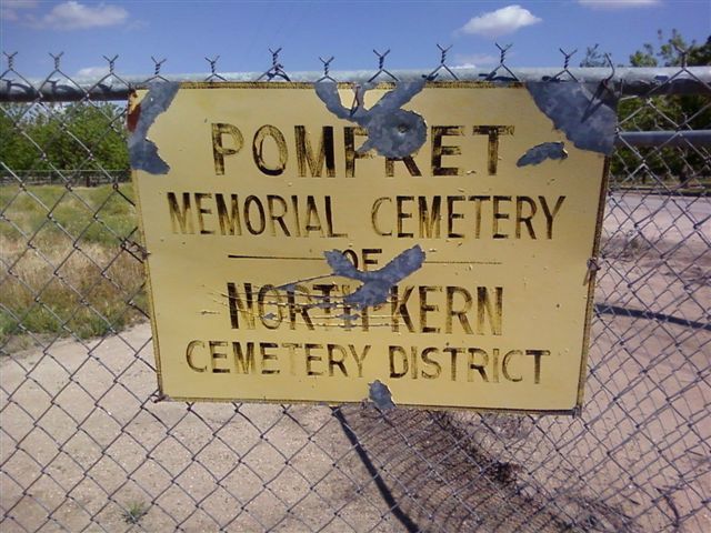
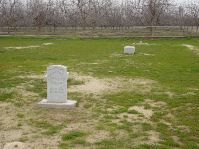
| Description | : | Located between the Famosa-Poso Road and the Southern Pacific right-of-way. Per great-granddaughter N Hayden: Michael Pomfret, set aside acreage on their homestead in Famoso (formerly Poso Station), CA as a family cemetery. Michael was the first to be buried there in 1888 followed by two of his daughters in 1893 and 1894. All the markers are missing now. from member # 46982422 Pomfret Memorial Cemetery as originally known as the Famoso Cemetery. It is an early pioneer cemetery serving Famosa, McFarland and the farming area around it. it is in the North Kern County Cemetery District, located at Philips Road and... Read More |
frequently asked questions (FAQ):
-
Where is Pomfret Memorial Cemetery?
Pomfret Memorial Cemetery is located at Famoso, Kern County ,California ,USA.
-
Pomfret Memorial Cemetery cemetery's updated grave count on graveviews.com?
9 memorials
-
Where are the coordinates of the Pomfret Memorial Cemetery?
Latitude: 35.6313580
Longitude: -119.2064460

Nearby Cemetories:
1. North Kern Cemetery
Delano, Kern County, USA
Coordinate: 35.7630560, -119.2580560
2. Wasco Memorial Park
Wasco, Kern County, USA
Coordinate: 35.6034740, -119.3845260
3. Shafter Memorial Park
Shafter, Kern County, USA
Coordinate: 35.4728012, -119.2341995
4. Engle Family Cemetery
Bakersfield, Kern County, USA
Coordinate: 35.6392060, -118.9231180
5. Allensworth Historical Cemetery
Tulare County, USA
Coordinate: 35.8438873, -119.3947220
6. Greenlawn Cemetery and Mortuary
Bakersfield, Kern County, USA
Coordinate: 35.4067001, -118.9856033
7. Kuntz Ranch Cemetery
Bakersfield, Kern County, USA
Coordinate: 35.4373560, -118.9390180
8. Saint Pauls Episcopal Church Columbarium
Bakersfield, Kern County, USA
Coordinate: 35.3746120, -119.0277940
9. Blue Mountain Cemetery
Woody, Kern County, USA
Coordinate: 35.7065500, -118.8322400
10. Weringer Cemetery
Woody, Kern County, USA
Coordinate: 35.7062100, -118.8320800
11. Chinese Cemetery
Bakersfield, Kern County, USA
Coordinate: 35.3510550, -119.0273380
12. Long Tom Mine Cemetery
Woody, Kern County, USA
Coordinate: 35.5495600, -118.8308700
13. Home of Peace Jewish Cemetery
Bakersfield, Kern County, USA
Coordinate: 35.3631500, -118.9987400
14. Union Cemetery
Bakersfield, Kern County, USA
Coordinate: 35.3646500, -118.9948700
15. Tailholt Boot Hill Cemetery
White River, Tulare County, USA
Coordinate: 35.8111110, -118.8452780
16. White River Cemetery
White River, Tulare County, USA
Coordinate: 35.8104350, -118.8412160
17. Hillcrest Memorial Park
Bakersfield, Kern County, USA
Coordinate: 35.3814316, -118.9012527
18. Greenlawn Southwest Mortuary and Cemetery
Bakersfield, Kern County, USA
Coordinate: 35.2948990, -119.0330810
19. Zion Lutheran Church Cemetery
Terra Bella, Tulare County, USA
Coordinate: 35.9775391, -118.9989014
20. Oak Grove Cemetery
Glennville, Kern County, USA
Coordinate: 35.7414017, -118.7157974
21. Galley Mountain Cemetery
Tulare County, USA
Coordinate: 35.8894005, -118.8069000
22. Tipton-Pixley Cemetery
Tipton, Tulare County, USA
Coordinate: 36.0505981, -119.3392029
23. Saint Annes Cemetery
Porterville, Tulare County, USA
Coordinate: 36.0401030, -119.0294190
24. Vandalia Cemetery
Porterville, Tulare County, USA
Coordinate: 36.0368900, -119.0049400