
| Memorials | : | 2 |
| Location | : | Gibbs, Adair County, USA |
| Coordinate | : | 40.1098000, -92.4496000 |
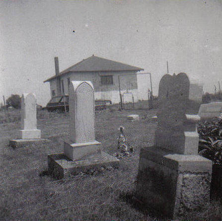
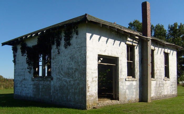
| Description | : | PRAIRIE BIRD CEMETERY The Prairie Bird Cemetery began in 1878 when Rev. Andrew Jackson Garlock and his wife, Jane, gave about one acre of land on which to build a church and have a cemetery. It was deeded for this purpose in 1881. This cemetery and church was originally named Pleasant View, but in the minds of the Prairie Bird community, it assumes that name. Andrew J. Garlock's father, Henry, along with is his wife, Esther and ten children, came to Kirksville, Missouri on Nov. 15, 1855 by covered wagon from Preston County, Virginia (now West Virginia). In 1856... Read More |
frequently asked questions (FAQ):
-
Where is Prairie Bird Cemetery?
Prairie Bird Cemetery is located at Gibbs, Adair County ,Missouri ,USA.
-
Prairie Bird Cemetery cemetery's updated grave count on graveviews.com?
2 memorials
-
Where are the coordinates of the Prairie Bird Cemetery?
Latitude: 40.1098000
Longitude: -92.4496000
Nearby Cemetories:
1. Gibbs Union Cemetery
Gibbs, Adair County, USA
Coordinate: 40.1030998, -92.4310989
2. Gibbs South Methodist Cemetery
Adair County, USA
Coordinate: 40.0995300, -92.4209100
3. Greenwood Farm Cemetery
Brashear, Adair County, USA
Coordinate: 40.1431500, -92.4210900
4. Wilsontown Cemetery
Wilson, Adair County, USA
Coordinate: 40.0661100, -92.3852400
5. Brashear Cemetery
Brashear, Adair County, USA
Coordinate: 40.1439018, -92.3739014
6. Bullion Cemetery
Kirksville, Adair County, USA
Coordinate: 40.1733900, -92.4878500
7. Cater Cemetery
Adair County, USA
Coordinate: 40.1467018, -92.5318985
8. Pitt Family Burying Ground
Salt River Township, Adair County, USA
Coordinate: 40.1827120, -92.4297730
9. La Plata Cemetery East Addition
La Plata, Macon County, USA
Coordinate: 40.0355600, -92.4880900
10. Stukey Cemetery
Millard, Adair County, USA
Coordinate: 40.1025009, -92.5567017
11. Rueben Long Family Cemetery
Salt River Township, Adair County, USA
Coordinate: 40.1857440, -92.4032830
12. Fairview School Cemetery
Knox County, USA
Coordinate: 40.1172500, -92.3361700
13. Paultown Cemetery
Brashear, Adair County, USA
Coordinate: 40.1608009, -92.3557968
14. Dent Family Cemetery
La Plata, Macon County, USA
Coordinate: 40.0287700, -92.5064100
15. Sabbath Home Church Cemetery
Brashear, Adair County, USA
Coordinate: 40.1998500, -92.4168600
16. Shaver Cemetery
Millard, Adair County, USA
Coordinate: 40.0780983, -92.5650024
17. La Plata Cemetery
La Plata, Macon County, USA
Coordinate: 40.0222630, -92.4971680
18. Mount Tabor Primitive Baptist Church Cemetery
Knox County, USA
Coordinate: 40.0837300, -92.3261500
19. Lansberry Cemetery
Knox County, USA
Coordinate: 40.0814018, -92.3261032
20. Bragg Cemetery
Adair County, USA
Coordinate: 40.0419006, -92.5483017
21. Park View Pet Memorial Gardens
Kirksville, Adair County, USA
Coordinate: 40.1649200, -92.5621600
22. Park View Memorial Gardens
Kirksville, Adair County, USA
Coordinate: 40.1669006, -92.5610962
23. Wright Cemetery
La Plata, Macon County, USA
Coordinate: 40.0141870, -92.5081840
24. Maple Hills Cemetery
Kirksville, Adair County, USA
Coordinate: 40.1669006, -92.5691986